MyTopo
Wyoming Antelope GMU 94 Map
Couldn't load pickup availability
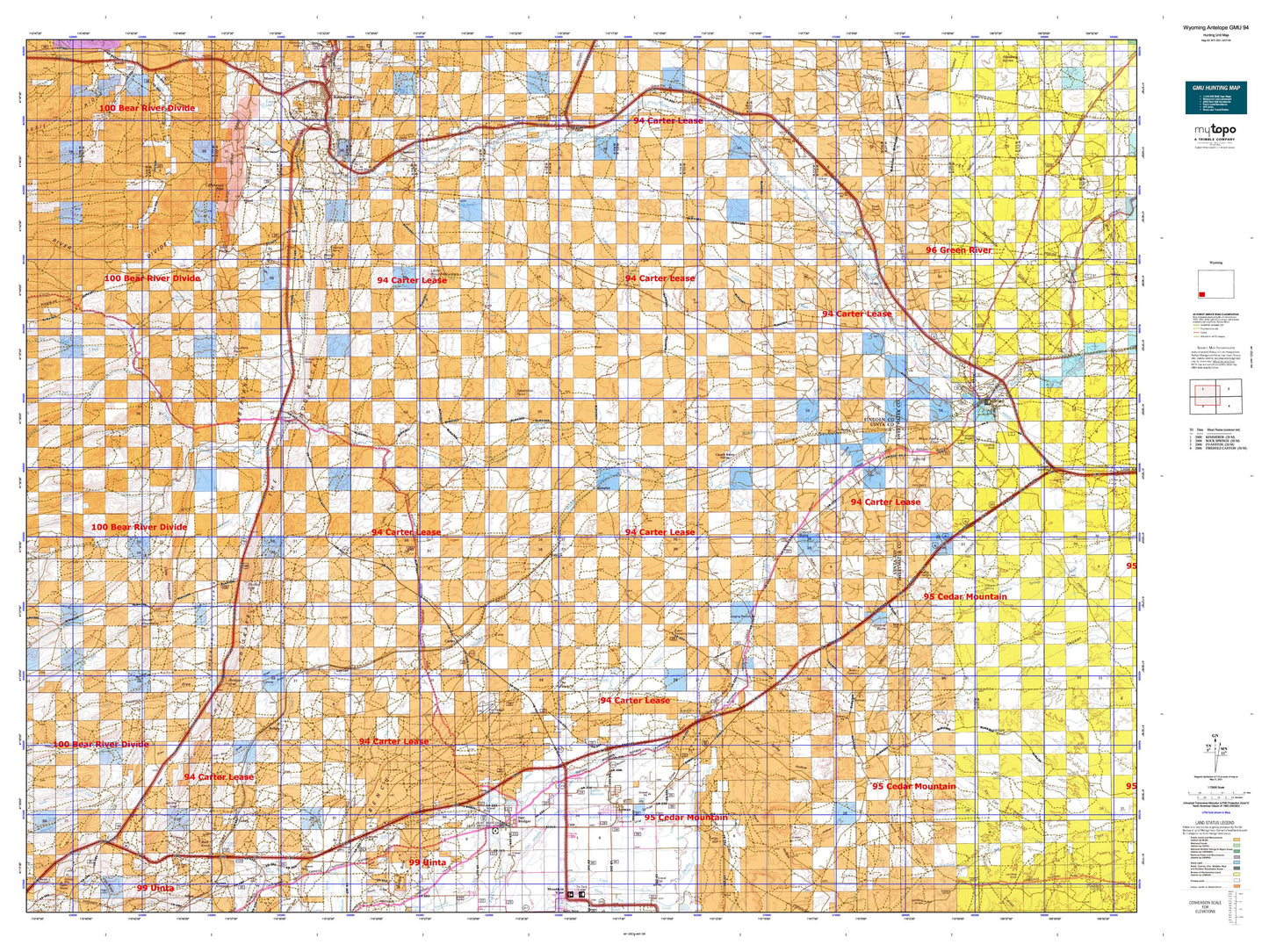
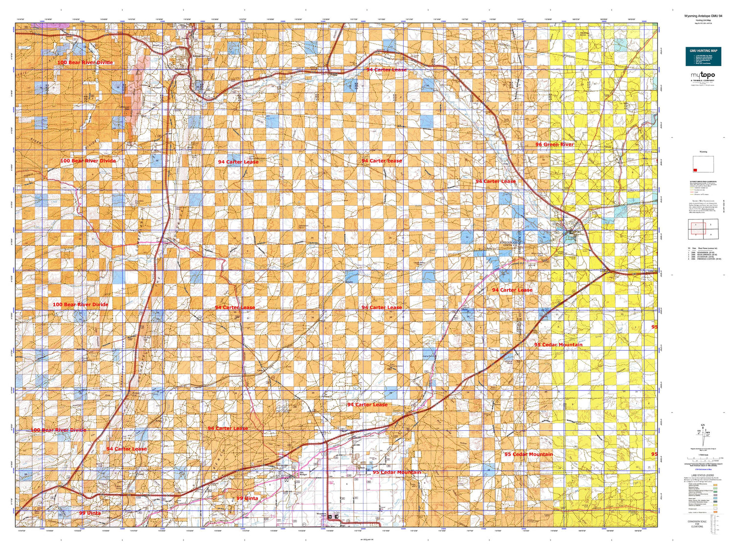
Hunting unit map of Wyoming Game Management Unit ANT-94 with topographic lines and unit boundaries. This topo map features UTM / MGRS and Latitude/Longitude grids, plus public land ownership. It comes folded on waterproof paper. Be fully prepared for your hunt with a MyTopo GMU map!.
This map contains the following named places: 82933,82934,82937,83116,83124,Adaville Mine,Aimo Dam,Aimo Reservoir,Albert Creek,Alkali Creek,Antelope,Antelope Knoll,Austin Canal,Austin Reservoir,Austin Wash,Bald Knoll,Bell Creek,Bertagonilli Mine,Biazon Mine,Bigelow Bench Reservoir,Blacks Fork Canal,Blazon Gap,Blazon Junction,Blazon Mine,Blumel Draw,Bridger,Bridger Butte,Bridger Gap,Bridger Valley Division,Brilliant Number Eight Mine,Broadbent Number 2 Dam,Broadbent Number 2 Reservoir,Bruff Draw,Butcher Knife Draw,Byrne Creek,Byrnes Draw,C H Smith Dam,C H Smith Reservoir,Carter,Carter Cedars,Carter Cemetery,Carter Census Designated Place,Carter Creek,Caterpillar Draw,Cavanaugh Peak,Center Ditch,Chicken Creek,Chrisman Bench,Chrisman Ditch Number 1,Church Butte,Church Butte Camp,Church Buttes Dam,Church Buttes Reservoir,Church Buttes Siding,City of Kemmerer,Clear Creek,Coal Mine Draw,Company Ranch,Conroy Mine,Cottonwood Creek,Cottonwood Hollow,Cow Hollow Creek,Craven Creek,Crockers Point,Cumberland Cemetery,Cumberland Flats,Cumberland Gap,Cumberland Gap Mine,Cumberland Number One Mine,Cumberland Number Three Mine,Cumberland Number Twenty-five Mine,Davis Mine,Davis Number 2 Dam,Davis Number 2 Reservoir,Desertion Point,Diamond Alkali Company Number One Mine,Diamondville,Diamondville Number 1 Mine,Dry Muddy Creek,Eakin Pumping Station,Elkhurst,Elkol,Elkol Strip Mine,Emigrant Trail,Erickson Dam and Reservoir,Erickson Reservoir,Fabian and Tyler Ditch,Fabian Ditch,Felter Creek,Fitzpatrick Mine,Fmc Dam,Fmc Reservoir,Fort Bridger,Fort Bridger Airport,Fort Bridger Canal,Fort Bridger Cemetery,Fort Bridger Census Designated Place,Glencoe Junction,Glencoe Mine,Granger,Granger Stage Station Historical Marker,Grassy Hollow,Groshon Creek,Guild Hollow,Hampton,Hams Fork,Hank Hollow,Haystack Draw,Hayward Place,Heard Hollow Creek,Hill Creek,Hinshaw Creek,Isaac Kampman Mine,Jackknife Draw,Jakes Mine,Junction Mine,Kemmerer Mine,Kendall Mine,Kidman Well Canal,Lazeart Mine,Leavitt Creek,Lee Mine,Lincoln Star Mine,Little Blacks Fork,Little Byrne Creek,Little Dee Creek,Little Hogsback,Little Muddy Creek,Little Round Mountain,Lost Draw,Lyman,Lyman City Cemetery,Lyman Draw,Meadow Draw,Millersville,Molinar Dam,Molinar Reservoir,Moore and Bagley Ditch,Moss Agate Cut,Moss Agate Knoll,Moxa,Moxa Ditch,Mud Spring Hollow,Muddy Creek,Mussleman Creek,Naughton Ash Pond Number 2,Naughton Ash Pond Number 2 Dam,North Fork Little Muddy Creek,North Fork Sheep Creek,Nutria,Nutria Ditch,Oakley Census Designated Place,Oakley Draw,Oakley Mine,Oasis Ditch,Old Dutch John Ranch,Old Mexican Ditch,Opal,Oyster Ridge Mine,Pacific Coal Company Mine,Painter Number 1 Dam,Painter Number 1 Reservoir,Paterson Lake Dam,Philbrick and Johnson Ditch,Pine Hollow Creek,Pine Ridge,Porter Hollow,Powers Stock Dam,Powers Stock Reservoir,Quarry Creek,Radiant Mine,Richardson Draw,Richardson Mine,Richey Dam,Richey Reservoir,Roberson Creek,Roberson Ditch,Rock Creek,Rock Hollow,Rocky Crossing,Round Mountain,Ryckman Creek,Scullys Gap,Sheep Creek,Sheep Draw,Shurtleff Creek,Skull Point,Skull Point Reservoir,Smiths Fork,Soda Hollow,South Creek,South Lincoln Cemetery,South Side Ditch,Spring Creek,Spring Gap,Storm Shelter Cabin Number 2,Sudden Number One Mine,Taylor Draw,Telephone Draw,Texasgulf-Trona Mine,The Hogsback,The Nipple,The Pinnacle,Thistle Hollow,Thornburgh Gravesite,Threemile Creek,Toms Draw,Town of Diamondville,Town of Granger,Town of Lyman,Town of Opal,Triangulation Point Draw,Turtle Hill,Twin Buttes Canal,Uinta County,Urie,Urie Census Designated Place,Urie Ditch,Urie Draw,Verne,Wall Reservoir,Wall Reservoir Dam,Warfield Creek,Wasmer Draw,Water Tank Number 8,Waterfall,Wells Flat,Whitney Creek,Wildcat Butte,Winslow Hallock and Capen Ditch,Wright Ditch,Yellow Point Fork Sevenmile Gulch,Ziegler Ditch,Zieglers Wash,Ziller Ranch