MyTopo
Wyoming Elk GMU 100 East Map
Couldn't load pickup availability
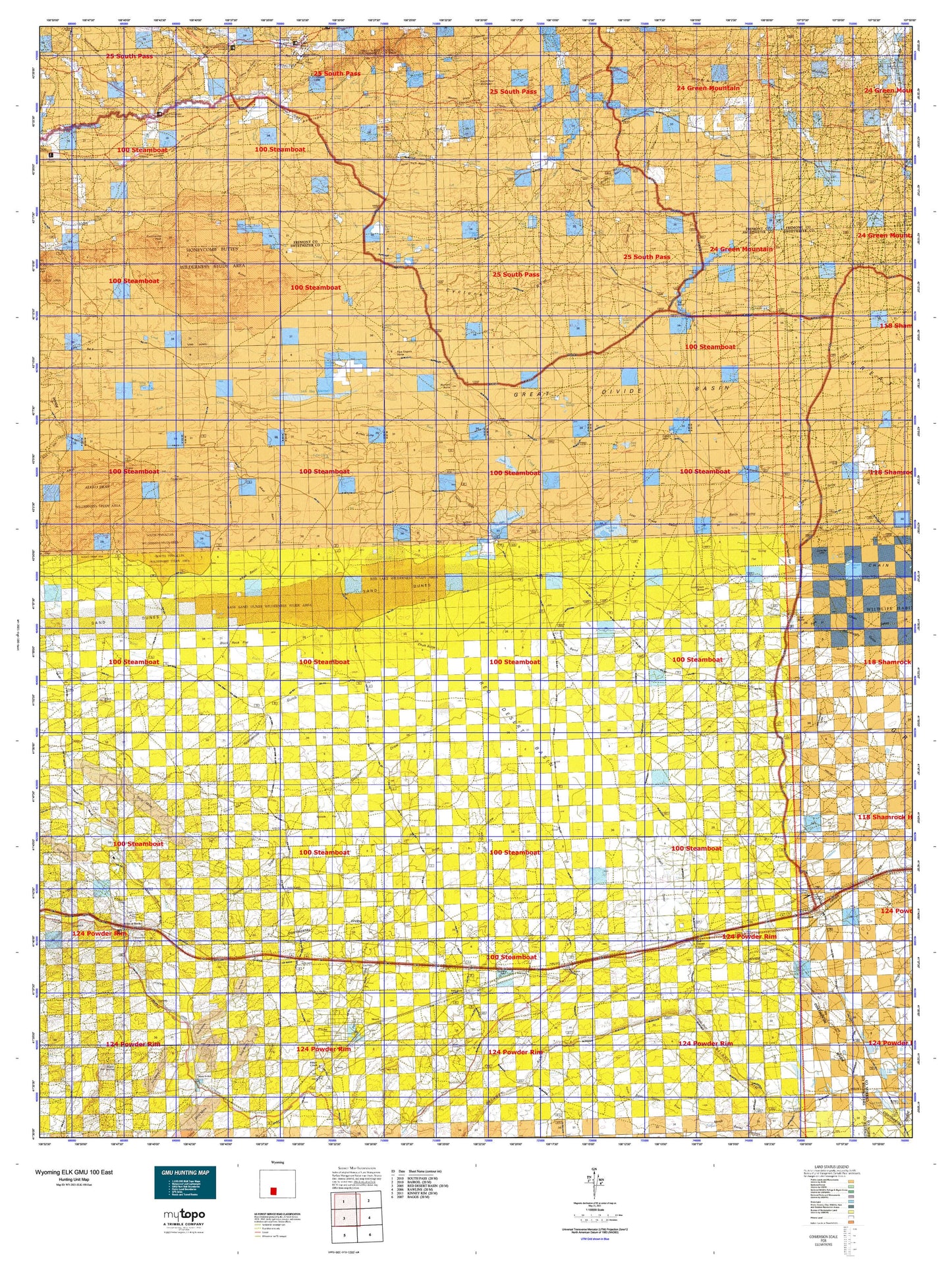
Hunting unit map of Wyoming Game Management Unit ELK-100-East with topographic lines and unit boundaries. This topo map features UTM / MGRS and Latitude/Longitude grids, plus public land ownership. It comes folded on waterproof paper. Be fully prepared for your hunt with a MyTopo GMU map!.
This map contains the following named places: 82336,Alkali Basin,Antelope Hills,Antelope Reservoir,Arapahoe Creek,Arapahoe Ditch,Arnold Spring,Baby Antelope Reservoir,Bar X Ranch,Bastard Butte,Battle Spring,Battle Spring Draw,Battle Spring Flat,Bear Creek,Beaver Dam Ditch,Big Bend,Big Hill,Bison Basin Oil Field,Bison Basin Project Mine,Black Lake,Black Rock,Black Rock Creek,Black Rock Flat,Black Rock Springs,Blake Sheep Camp,Brannan Number 1 Dam,Brannan Number 1 Reservoir,Brannan Reservoir,Brenton Springs,Buck Spring,Buffalo Basin,Buffalo Bill Camp,Buffalo Gulch,Buffalo Hump,Buffalo Hump Basin,Buffalo Hump Lake,Burnt Ranch Ditch,Burnt Ranch Historical Monument,Burr Gulch,Burr Mine,Bush Creek,Bush Creek Dam,Bush Creek Reservoir,Bush Lake,Buzzard Sheep Camp,Carpenter Ranch,Caterpillar Butte,Chalk Butte,Chicken Springs,Circle Bar Lake,Circle Bar Sheep Camp,Coal Bank Wash,Coal Butte,Cold Spring Reservoir,Continental Peak,Cow Camp Spring,Coyote Gulch,Coyote Lake,Cronin Draw,Crooks Mountain,Cyclone Draw,Cyclone Rim,Daley Lake,Deadman Wash,Delaney Rim,Dennison Cap,Desert Springs,Dickie Springs Creek,Dickie Springs-Oregon Gulch Number One Mine,Dry Lake,Dugout Draw,Eagle Nest Draw Reservoir Number 1 Dam,Eagles Nest,Eagles Nest Draw,Eagles Nest Draw Reservoir Number One,Eagles Nest Spring,East Alkali Creek,East Arapahoe Creek,East Fork Sourdough Gulch,Echo Springs Draw,Eight Lazy Y Ranch,Erramouspe Place,Eye of the Eagle,Five Fingers Butte,Fivemile Ditch,Fivemile Lake,Flattop Buttes,Fourth of July Wash,Frewen,Frewen Lake,Government Reservoir,Granite Creek,Grassy Lake,Greasewood Wash,Great Divide Basin,Hadsell Cabin,Hadsell Dam,Hadsell Place,Hadsell Reservoir,Hallville,Hansen Draw,Hansen Lake,Happy Springs Oil Field,Harris Ditch,Harris Slough,Hay Dam,Hay Gulch,Hay Reservoir,Hay Reservoir Landing Strip,Honeycomb Buttes,Horse Pasture Draw,Horse Track Ridge,Horseshoe Bend,Jabcig Mine,Jim Bridger Mine,Jim Bridger Power Plant Surge Pond Dam,Jim Bridger Project Evaporation Pond,Jim Bridger Project Evaporation Pond Dam,Jim Bridger Reservoir,John Hay Reservoir,Kindt Ranch,Lame Jack Gulch,Larsens Ranch,Last Chance Number Three Mine,Last Crossing Ford Number 9,Latham Draw,Lecite Hills Mine,Little Bar X Draw,Little Osborne Lake,Little Sand Dunes,Long Gulch,Long Slough,Lost Creek,Lost Creek Basin,Lost Creek Butte,Lost Creek Butte Lake,Lost Creek Lake,Lost Creek Reservoir,Luman Butte,Luman Ranch,Luman Rim,Magpie Creek,McCann Lake,McKay Lake,McKay Reservoirs,Meadow Creek,Merrimac Mine,Middle Fork Sulphur Creek,Monell,Monument Lake,Mud Lake,Murray Lake,Ninemile Wash,North Bear Mountain,North Fork Bear Creek,North Fork Sulphur Creek,Old Osborne Cabin,Oregon Gulch,Oregon Slough,Osborne Draw,Osborne Reservoir,Overland Trail,P B Creek,Patrick Draw,Patrick Draw Oil Field,Picket Creek,Picket Lake,Pine Creek,Point of Rocks,Point of Rocks Census Designated Place,Point of Rocks Mine,Point of Rocks Stagecoach Station,Potash Wash,Rambaud Number 1 Dam,Rambaud Number 1 Reservoir,Rambaud Number 2 Dam,Rambaud Number 2 Reservoir,Rasmussen Sheep Camp,Red Creek,Red Desert,Red Desert Basin,Red Desert Project Mine,Red Hill Mine,Red Lake,Red Wash Draw,Robinson,Rock Creek,Rocky Crossing,Saint Marys Peak,Salt Sage Draw,Sand Creek,Scotty Lake,Sheep Mountain Operations Mine,Siberia Ridge,Slaughterhouse Gulch,Smiley Draw,Sourdough Butte Mine,Sourdough Gulch,South Fork Sulphur Creek,Standard Draw,State School Number One Mine,Stinking Springs Draw,Stinking Springs Reservoir,Strandburg Ranch,Stratton Lakes,Sulphur Creek,Sweetwater Uranium Mine,Table Rock,Table Rock Census Designated Place,Table Rock Oil and Gas Field,Tenmile Draw,Tenmile Flat,Tenmile Reservoir Number 3,Tenmile Reservoir Number 4,Tenmile Rim,The Meadows,The Pinnacles,Threemile Ditch,Threemile Meadow,Tipton,Town of Wamsutter,Twelvemile Gulch,Twelvemile Hole,Wamsutter,Wamsutter Division,Wamsutter Gas Field,Wamsutter Rim,Weasel Draw,Wells Bluff,West Alkali Creek,West Arapahoe Creek,Willow Creek,Wilson Gulch,Woods Gulch Pond,Yellowstone Cow Camp