MyTopo
Wyoming Elk GMU 108 Map
Couldn't load pickup availability
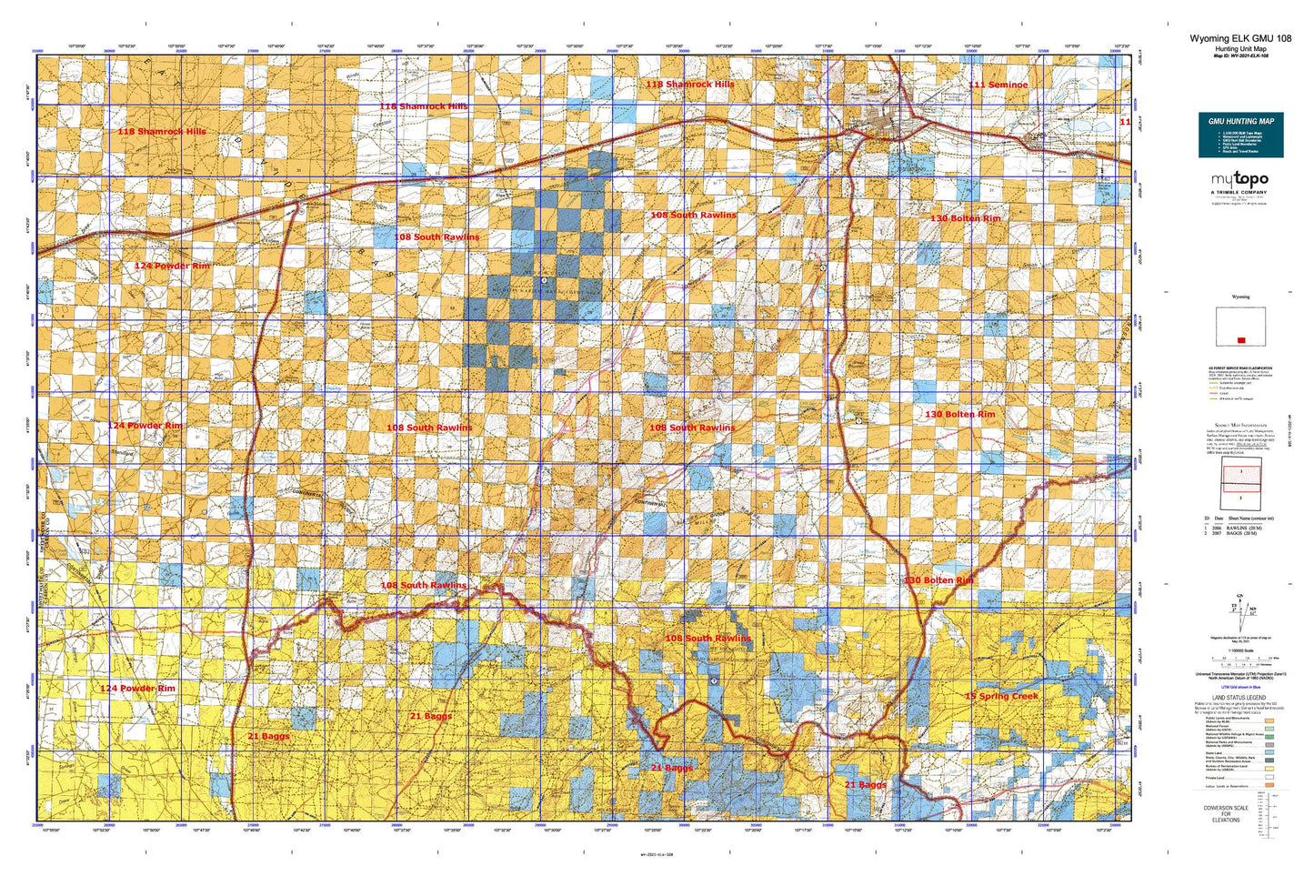
Hunting unit map of Wyoming Game Management Unit ELK-108 with topographic lines and unit boundaries. This topo map features UTM / MGRS and Latitude/Longitude grids, plus public land ownership. It comes folded on waterproof paper. Be fully prepared for your hunt with a MyTopo GMU map!.
This map contains the following named places: 44 Ranch,Adams Dam,Adams Reservoir,Alamosa Gulch,Antelope Creek,Atlantic Rim,Atlantic Rim Mine,Bad Water Creek,Baldy Butte,Baur Ranch,Bear Gulch,Beaver Pond,Beckman Canyon,Beckman Spring,Bridger Pass,Buck Springs Draw,Bull Canyon,Cabin Draw,Canary Grove Draw,Cherokee,Cherokee Hill,Cherokee Mine,Cherokee Mine Number 1,Cherokee Mine Number 2,Cherokee Project Number One Mine,Cherokee Project Number Two Mine,Chicken Pete Spring,Chicken Spring,Chicken Springs Wash,China Butte,Chokecherry Knob,Coal Bank Creek,Coal Bank Lake,Coal Bank Spring,Coal Bank Wash,Coal Mine Draw,Coal Mine Ridge,Continental Divide Mine,Cow Butte,Creston,Creston Junction,Cy Draw,Daley Ranch,Deadman Creek,Deadman Springs,Dillon Mine,Doty Mountain,Duck Lake,Eagle Creek,Echo Springs,Eightmile Lake,Eightmile Lake Basin,Emigrant Creek,Emigrant Trail,Fillmore Ranch,Five Mile Ditch Mine,Fivemile Hole,Fivemile Lake,Fivemile Ridge,Garza Spring,Government Number 1 Reservoir Dam,Government Reservoir,Green Canyon,Grove Creek,Hadsell Dam,Hadsell Place,Hadsell Reservoir,Hansen Draw,Hatfield Oil Field,Hay Gulch,High Point,Hogback Lake,Hogback Ridge,Holler Draw,Horse Butte,Horse Gulch,Horse Pasture Draw,J O Dam,J O Reservoir,Jep Canyon,Johnson Ranch,La Marsh Creek,Lake Draw,LaMarsh Ranch,Lambertsen Ranch,Latham,Little Coal Gulch,Little Sage Creek Dam,Littlefield Creek,Lone Tree Creek,McCarthy Ranch,McKeil Homestead,McKinney Creek,Middlewood Creek,Middlewood Hill,Middlewood Ranch,Midget Geyser,Miller Hill,Miller Hill Lake,Muddy Spring Creek,Ninemile Spring,Olson Cabin,Olson Draw,Olson Well,Original Stage Station,Piker Spring,Pine Bed Mine,Pine Butte,Pine Grove Creek,Pine Grove Ranch,Pole Gulch,Ram Canyon,Rawlins Dam,Rawlins Division,Rawlins Peaking Dam,Rawlins Peaking Reservoir,Rawlins Reservoir,Red Rim,Riner,Robertson Mine,Robinson Canyon,Sage Creek Basin,Sage Creek Stage Station,Scotty Canyon,Seaverson Dam,Seaverson Reservoir,Separation Peak,Sheep Mountain,Sheep Mountain Reservoir,Sixteenmile Draw,Sixteenmile Reservoir,Slide Draw,Snowshoe Canyon,Soap Hole Wash,Squaw Canyon,Standard Draw,Stoney Creek,Sugar Loaf,Sulphur Springs Ranch,Teton Reservoir,Teton Reservoir Dam,The Sand Hills,The Willows,Trapper Creek,Washakie Station,Wild Horse Canyon,Wyoming State Penitentiary