MyTopo
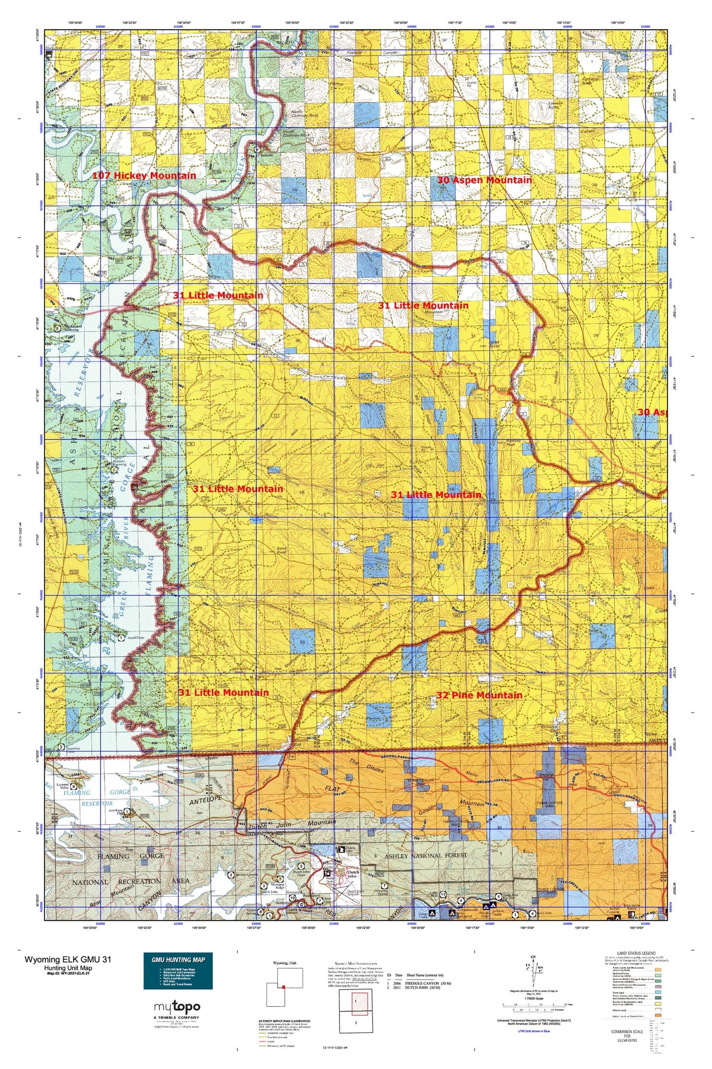
Wyoming Elk GMU 31 Map
Couldn't load pickup availability
Hunting unit map of Wyoming Game Management Unit ELK-31 with topographic lines and unit boundaries. This topo map features UTM / MGRS and Latitude/Longitude grids, plus public land ownership. It comes folded on waterproof paper. Be fully prepared for your hunt with a MyTopo GMU map!.
This map contains the following named places: Angelovie Spring,Antelope Butte,Antelope Flat,Antelope Flat Campground,Antelope Flat Development,Anvil Wash,Bates Spring,Big Pasture,Big Ridge,Big Spring,Blacks Fork,Brinegar Ferry,Brinegar Ranch,Brown Spring,Buckskin Basin,Burnt Canyon,Buster Basin,Camp Creek,Camp Creek Springs,Canyon Road Trail,Castello Creek,Castello Spring,Chokecherry Draw,Clay Basin,Clay Basin Camp,Clay Basin Creek,Clay Basin Wildlife Management Area,Coal Mine Draw,Coyote Spring,Currant Creek,Currant Creek Ranch,Currant Creek Ridge,Daniels Creek,Davis Spring,Deer Spring,Dipping Spring Canyon,Dry Canyon,Dry Hollow,Dutch John Gap,Dutch John Mountain,Earnest Butte,East Fork Currant Creek,East Fork Trout Creek,East Grindstone Spring,Edith Aspden Park,Ely Creek,Ely Spring,Faulkner Draw,Firehole Basin,Firehole Canyon,Firehole Canyon Campground,Flaming Gorge Reservoir,Flat Iron,Flattop Mountain,Ford Draw,Ford Spring,Gooseberry Creek,Goslin Mountain,Goslin Mountain Wildlife Management Area,Greasewood Draw,Greasewood Spring,Green River Mine,Greenhough Creek,Greenhough Flats,Greenhough Place,Grindstone Spring,Grindstone Wash,Hanks Meadow,Harris Spring,Hawks Nest,Hogback,Holmes Crossing Recreation Site,Iron Mountain,Janes Meadow,Jarvies Marsh Creek,Johnson Draw,Jones Springs,Kastler Compressor Station Airport,Krause Marsh Creek,Little Mountain,Little Mountain Mine,Logan Place,Lousy George Spring,Lowe Canyon,Martin Draw,Maxon Ranch,Meadow Gulch,Mellor Mountain,Menkeinney Mine,Middle Fork Currant Creek,Middle Marsh Creek,Minnies Gap,North Chimney Rock,Parea Butte,Parea Spring,Pigeon Basin,Pigeon Canyon,Ramsay Desert,Ramsay Ranch,Ramsey Peak,Rawlins Draw,Red Jeep Number One Mine,Richards Gap,Richards Mountain,Richards Mountains,Richards Spring,Sage Creek,Sage Creek Basin,Sage Creek Mine,Sage Creek Ranch,Sally Draw,Sand Knoll,Sheep Mountain,Snow Creek,South Chimney Rock,Spitzi Creek,Spitzi Spring,Spring Creek,Squaw Hollow,Sugarloaf Basin,Sugarloaf Marsh Creek,Sugarloaf Reservoir,The Confluence,The Glades,The Narrows,Trough Draw,Trout Creek,Upper Marsh Creek,Upper Marsh Creek Boat Ramp,Upper Marsh Creek Recreation Site,Washam Spring,Washam Wash,Webster Dugway,West Fork Currant Creek,West Fork Trout Creek,West Spring Creek,Whiskey Bend,Wildhorse Basin,Wildhorse Draw,Worm Creek