
MyTopo
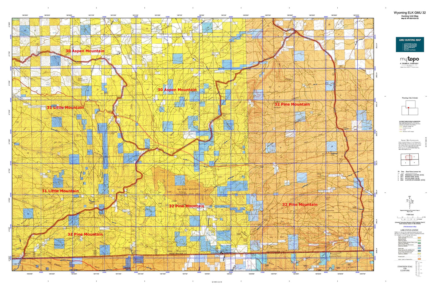
Wyoming Elk GMU 32 Map
Couldn't load pickup availability
Hunting unit map of Wyoming Game Management Unit ELK-32 with topographic lines and unit boundaries. This topo map features UTM / MGRS and Latitude/Longitude grids, plus public land ownership. It comes folded on waterproof paper. Be fully prepared for your hunt with a MyTopo GMU map!.
This map contains the following named places: Alkali Creek,Alkali Springs,Angelovie Spring,Bates Spring,Beans Spring,Beans Spring Creek,Beef Steer Creek,Beef Steer Spring,Bell Spring,Big Pasture,Big Ridge,Big Spring,Brown Spring,Buckskin Basin,Buffalo Spring,Camp Creek,Camp Creek Springs,Castello Creek,Castello Spring,Chicken Spring Pond,Coal Mine Draw,Corral Creek,Coyote Spring,Currant Creek Ranch,Currant Creek Ridge,Daniels Creek,Dans Creek,Davis Spring,Deer Spring,Dipping Spring Canyon,Dodge Meadows,Dry Canyon,Dry Hollow,East Fork Currant Creek,East Fork Trout Creek,Elk Butte,Ely Creek,Ely Spring,Faulkner Draw,Flat Iron,Four J Basin,Four J Rim,Gap Creek,Gap Spring,Goat Spring,Gooseberry Creek,Graham Ranch,Greasewood Draw,Greasewood Spring,Greenhough Creek,Greenhough Flats,Greenhough Place,Hanks Meadow,Harris Spring,Hawks Nest,Hazel Creek,Hogback,Horseshoe Spring,Iron Mountain,Iron Spring,Janes Meadow,Jim Spring,Jim Washum Spring,John Erickson Dam,John Erickson Reservoir,Johnson Draw,Jones Springs,June Creek,Laney Canyon,Laney Rim,Laney Spring,Little Basin Creek,Little Basin Ranch,Little Mountain,Little Mountain Mine,Little Red Creek,Lizzie Spring Creek,Logan Place,Lousy George Spring,Maggie Springs,Maxon Ranch,McCort Canyon,McKnight Creek,Meadow Gulch,Meadow Gulch Ranch,Mellor Mountain,Menkeinney Mine,Middle Fork Currant Creek,Minnies Gap,Mud Mine,Parea Butte,Parea Spring,Pine Claim,Pine Lake,Pine Mountain,Pine Mountain Area Mine,Pio Moses Ranch,Pio Reservoir,Pio Spring,Poison Spring,Potter Mountain,Potter Mountain Reservoir,Ramsay Desert,Ramsay Ranch,Ramsey Peak,Red Creek Badlands,Red Creek Basin,Red Creek Ranch,Red Creek Ranch Airport,Red Jeep Number One Mine,Richards Gap,Richards Mountain,Richards Mountains,Richards Spring,Rock Springs South Division,Sage Creek Mine,Sage Creek Ranch,Sally Draw,Sand Knoll,Scrivner Canyon,Sheep Mountain,Snow Creek,Spitzi Creek,Spitzi Spring,Spring Creek,Star Numbers Five and Six Mine,Sugarloaf Basin,Sugarloaf Reservoir,Telephone Canyon,Tepee Creek,The Narrows,Titsworth Gap,Titsworth Spring,Tommy James Basin,Tommy James Creek,Trough Draw,Trout Creek,Wallace Cabin,West Fork Currant Creek,West Fork Trout Creek,West Spring Creek


