
MyTopo
Wyoming Elk GMU 51 Map
Couldn't load pickup availability
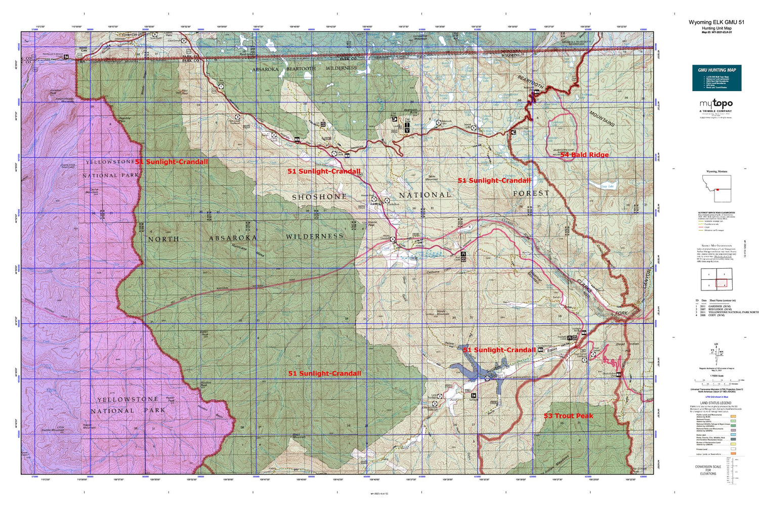
Hunting unit map of Wyoming Game Management Unit ELK-51 with topographic lines and unit boundaries. This topo map features UTM / MGRS and Latitude/Longitude grids, plus public land ownership. It comes folded on waterproof paper. Be fully prepared for your hunt with a MyTopo GMU map!.
This map contains the following named places: Abiathar Peak,Amphitheater Mountain,B Four Ranch,Badger Spring,Beartooth Butte,Beartooth Creek,Beartooth Falls,Beartooth Highlakes Trail,Beartooth Lake,Beartooth Lake Campground,Beartooth Pass,Beauty Lake,Beauty Lake Trail,Beem Gulch,Bird Mountain,Black Mountain,Black Stone Lake,Blacktail Creek,Bootjack Gap,Brown Bear Spring,Burnt Gulch,Cache Creek Patrol Cabin,Cache Mountain,Camp Creek,Camp Creek Quarry,Canoe Lake,Canyon Creek,Cary Pit,Cathedral Cliffs,Chain Lakes,Clarks Fork Trailhead,Clarks Fork Wild and Scenic River,Clay Butte,Clay Butte Trail,Cliff Lake,Closed Creek,Corral Creek,Cow Creek,Crandall Creek,Crandall Cutoff Trail,Crandall Ranger Station,Crandall Trail,Crane Lake,Crazy Creek,Crazy Creek Campground,Crossbow Ranch,Daphnia Lake,Deadman Creek,Deweys Gateway,Dodd Ranch,Dollar Lake,Double Spearhead Bar Ranch,Duck Lake,East Fork Painter Gulch,Elk Lakes,Ellsbury Ranch,Eye of the Needle,Fantan Lake,Few Acres Ranch,Fort Lake,Fox Creek Campground,Frozen Lake,Geers Point,Ghost Creek,Gilbert Creek,Granite Loop Trail,Gravelbar Creek,Grayling Lake,Guitar Lake,Hague Mountain,Hauser Lake,Hoodoo Basin,Hoodoo Creek,Hoodoo Peak,Huff Gulch,Hunter Peak,Hunter Peak Campground,Hunter Peak Ranch,Hurricane Mesa,Indian Peak,Island Lake,Island Lake Campground,Jim Smith Creek,Jim Smith Peak,K Bar Z Ranch,L Bar Ranch,Lake Creek,Lake Creek Campground,Lake WGN,Lazy Open A,Lewis and Clark Trail,Lily Lake,Little Bald Ridge,Little Bear Creek,Little Bear Lake,Little Moose Lake,Little Saddle Mountain,Little Sulphur Creek,Little Sunlight Campground,Little Sunlight Creek,Lodge Pole Creek,Lodgepole Trail,Long Lake,Long Lake Campground,Losekamp Lake,Lost Lake,Lost Lake Trail,Luckinbill Airstrip,Macy Ranch,Marguerite Draw,Meadow Lake,Miller Creek Trail,Muddy Creek,Night Lake,North Crandall Trail,North Crandall Trailhead,North Fork Crandall Creek,Oliver Gulch,One Hunt Creek,Onemile Creek,Orr Ranch,Painter Gulch,Papoose Creek,Papoose Trail,Paradise Lake,Parker Peak,Pilot Creek,Pilot Creek Trail,Pilot Peak,Quarter Circle Ranch,Quintuple Peaks,R D S Ranch,Rainbow Lake,Reef Creek,Reef Creek Campground,Reef Creek Trail,Republic Pass,Republic Peak,Riddle Ranch,Rock Creek,Rocky Ford,Russell Peak,Saddle Mountain,Sawtooth Lake,Sawtooth Meadows,Sheepherder Lake,Sill Lake,Snowshoe Creek,Snyder Lake,Solar Lake,Sparhawk Lake,Spink Ranch,Spring Creek,Squaw Creek,Squaw Creek Trail,Squaw Peak,State Highway Maintenance Camp,Stockade Lake,Sugarloaf Mountain,Sunlight Basin,Sunlight Ranch,Sunlight Ranger Station,Swamp Lake,Table Creek,Table Mountain,Temple Creek,Tepee Creek,The Needle,Thief Creek,Tibbs Butte Mine,Timber Creek,Top Lake,Tough Creek,Trail Creek,Upper Miller Creek Patrol Station,White Mountain,White Mountain Gulch,Willow Park,Windy Mountain,Wolverine Creek,Woody Ridge


