
MyTopo
Wyoming Elk GMU 52 Map
Couldn't load pickup availability
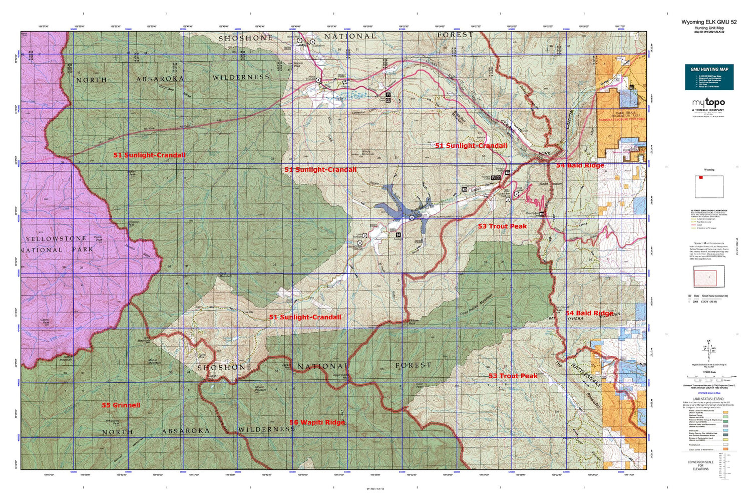
Hunting unit map of Wyoming Game Management Unit ELK-52 with topographic lines and unit boundaries. This topo map features UTM / MGRS and Latitude/Longitude grids, plus public land ownership. It comes folded on waterproof paper. Be fully prepared for your hunt with a MyTopo GMU map!.
This map contains the following named places: Agee Creek,Antelope Mountain,Arrow Creek,Badger Spring,Barrs Creek,Bear Springs,Beem Gulch,Big Creek Falls,Big Tree Creek,Black Mountain,Blackbird Creek,Blacktail Creek,Bootjack Gap,Braten Ranch,Brown Bear Spring,Burnt Gulch,Camp Creek,Camp Creek Quarry,Camp Monaco,Canoe Lake,Castor Peak,Cathedral Cliffs,Clarks Fork Wild and Scenic River,Closed Creek,Company Creek,Copper Creek,Copper Lakes,Corbitt Ranch,Cow Creek,Crandall Cutoff Trail,Crandall Ranger Station,Crandall Trail,Dead Indian Campground,Dead Indian Creek,Dead Indian Meadows,Dead Indian Pass,Dead Indian Peak,Dead Indian Ranch,Deadman Creek,Deweys Gateway,Dike Creek,Dike Mountain,Dillworth Bench,Dillworth Creek,Dodd Ranch,Double Spearhead Bar Ranch,Dry Fork,Dunn Creek,Dutch Charlie Creek,East Fork Painter Gulch,Elk Creek,Elk Lakes,Elkhorn Peak,Ellsbury Ranch,Evening Star Mine,Fall Creek,Fly Creek,Frank N Hammitt Monument,Galena Creek,Gas Creek,Geers Point,Grant Peak,Gravelbar Creek,Hardee Cabins,Hoodoo Basin,Hoodoo Creek,Hoodoo Peak,Huff Gulch,Hughes Basin,Hughes Creek,Indian Peak,Iron Creek,Jaggar Creek,Jaggar Peak,K Bar Z Ranch,Lamar Mountain,Land Mountain,Lazy Open A,Leaning Tree Creek,Lee City,Little Bald Ridge,Little Sulphur Creek,Little Sunlight Campground,Little Sunlight Creek,Lodge Pole Creek,Lodgepole Trail,Luckinbill Airstrip,Macy Ranch,Marguerite Draw,Middle Creek,Mooncrest Ranch,Moose Mountain,Morning Creek,Morrison Ranch,Morrison Trail,Mount Pleasant,Newton Prospect,Nipple Mesa,North Crandall Trailhead,North Fork Crandall Creek,Notch Mountain,Novelty Mine,Oliver Gulch,One Hunt Creek,Painter Cabin,Painter Gulch,Painter Mine,Papoose Creek,Papoose Trail,Park County Fire Protection District 2 - Station 6,Parker Peak,Pearson Cabin,Pollux Peak,Quarter Circle Ranch,Red Creek,Reef Creek Campground,Reef Creek Trail,Riddle Ranch,Robbers Roost Cabin,Rocky Ford,Russell Creek,Russell Peak,Salinger Ranch,Sheephead Creek,Silvertip Basin,Snowshoe Creek,Spink Ranch,Spring Branch,Spring Creek,Stinkingwater Peak,Stockdale Creek,Strawberry Gulch,Sugarloaf Mountain,Sulphur Camp,Sulphur Creek,Sulphur Lake,Sunlight Basin,Sunlight Creek,Sunlight Mining Region,Sunlight Peak,Sunlight Picnic Ground,Sunlight Ranch,Sunlight Ranger Station,Swamp Lake,Sweetwater Creek Falls,Temple Creek,The Box,The Wall,Timber Creek,Torrent Creek,Trail Creek,Trout Creek Trail,Trout Peak,Upper Dillworth Bench,Upper Lamar River Patrol Station,Upper Miller Creek Patrol Station,Whirlwind Peak,White Mountain,White Mountain Gulch,Wilson Creek,Windy Mountain,Winona Camp,Wolverine Creek


