MyTopo
Wyoming Elk GMU 53 Map
Couldn't load pickup availability
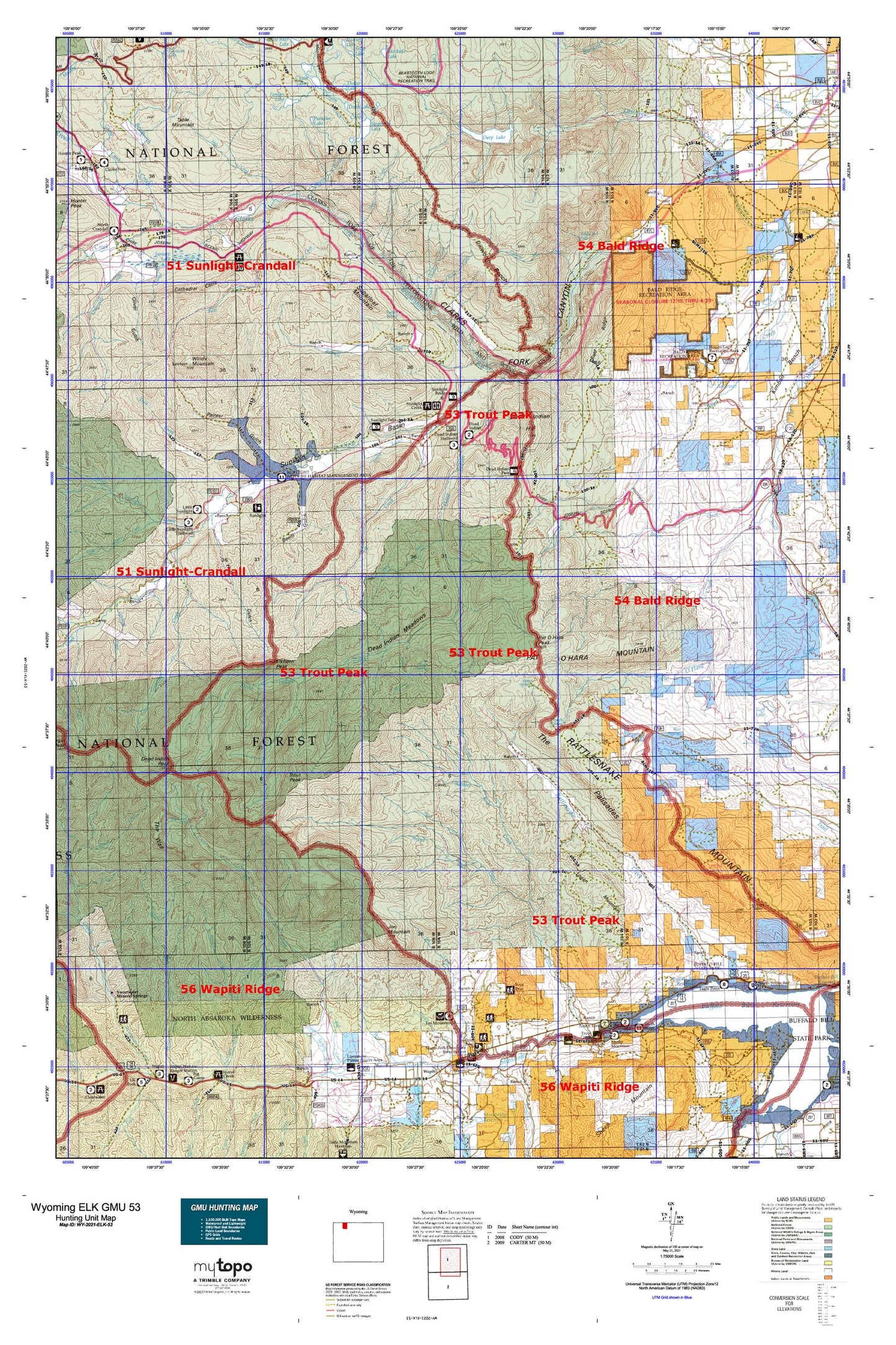
Hunting unit map of Wyoming Game Management Unit ELK-53 with topographic lines and unit boundaries. This topo map features UTM / MGRS and Latitude/Longitude grids, plus public land ownership. It comes folded on waterproof paper. Be fully prepared for your hunt with a MyTopo GMU map!.
This map contains the following named places: 82414,82450,Agee Creek,Antelope Mountain,Badger Spring,Bakers Ranch,Bald Peak,Bald Ridge,Barrs Creek,Bear Springs,Beartooth Creek,Beem Gulch,Big Creek Ditch,Big Creek Falls,Big Tree Creek,Bird Mountain,Blue Springs,Braten Ranch,Bridal Veil Falls,Broken H Lodge,Browns Mine,Buffalo Bill Reservoir,Burnt Gulch,Burnt Timer Creek,Camp Creek,Camp Creek Quarry,Camp Sawtooth,Canyon Creek,Cathedral Cliffs,Celotex Quarry,Chain Lakes,Chalk Mountain,Chinese Wall,Circle H Ranch,Clark Ranch,Clarks Fork Canyon,Clarks Fork Wild and Scenic River,Cles Ranch,Cliff Lake,Cody Division,Corbitt Ranch,Corral Creek,Crandall Creek,Cyclone Bar,Cyclone Bar Creek,Davidson Ranch,Dead Indian Campground,Dead Indian Creek,Dead Indian Gulch,Dead Indian Hill,Dead Indian Meadows,Dead Indian Mine,Dead Indian Pass,Dead Indian Peak,Dead Indian Ranch,Deadman Creek,Deep Creek,Deep Lake,Deep Lake Slide Area,Deweys Gateway,Dillworth Bench,Dillworth Creek,Dodd Ranch,Dollar Lake,Double Spearhead Bar Ranch,Dry Fork,Duck Lake,Dunn Creek,Dutch Charlie Creek,East Fork Big Creek,East Fork Painter Gulch,Elk Creek,Elk Lakes,Elkhorn Peak,Ellsbury Ranch,Falls Creek,Fantan Lake,Fly Creek,Four Bear Ranch,Frank N Hammitt Monument,Ghost Creek,Gravelbar Creek,Gunnysack Creek,Hoff Ranch,Hogan Reservoir,Huff Gulch,Iron Creek,Iron King Claims,Jim Mountain,K Bar Z Ranch,Lake Creek Ditch,Lake WGN,Laughing Water Creek,Lazy Open A,Leaning Tree Creek,Lewis and Clark Trail,Little Bald Ridge,Little Sulphur Creek,Little Sunlight Campground,Little Sunlight Creek,Logan Mountain,Luce Dam,Luce Reservoir,Luckinbill Airstrip,Macy Ranch,Marguerite Draw,Martins Ranch,Meadow Lake,Middle Creek,Monument Hill,Mooncrest Ranch,Morning Creek,Morrison Ranch,Morrison Trail,Murray Creek,Natural Corral,Newmeyer Creek,North Fork Shoshone River,Northfork Pit,Oliver Gulch,Oxyoke Canyon,Paint Creek School,Painter Gulch,Paradise Lake,Park County,Park County Fire Protection District 2 - Station 6,Pat O'Hara Basin,Pat O'Hara Mountain,Pat O'Hara Peak,Pearson Cabin,Post Creek,Quarter Circle Ranch,Rapid Creek,Rattlesnake Canyon,Rattlesnake Creek,Rattlesnake Mountain,Red Ridge,Reef Creek,Reef Creek Campground,Reef Creek Trail,Rhodes Ranch,Riddle Ranch,Robbers Roost Cabin,Robbers Roost Creek,Rocky Ford,Russell Creek,Russell Peak,Salinger Ranch,Sawtooth Lake,Sawtooth Meadows,Sawtooth Mountain,Sheep Creek,Sheephead Creek,Singing Brook,Snowshoe Creek,Sparhawk Lake,Spink Ranch,Spout Springs,Spring Branch,Spring Creek,Stockdale Creek,Sugarloaf Mountain,Sunlight Basin,Sunlight Creek,Sunlight Picnic Ground,Sunlight Ranch,Sunlight Ranger Station,Swamp Lake,Sweetwater Creek Mine,Table Creek,Table Mountain,The Box,The Palisades,The Wall,Thief Creek,Top Lake,Trail Creek,Trough Spring,Trout Creek,Trout Creek Ranch,Trout Creek Trail,Trout Peak,Two Dot Flats,Two Dot Ranch,Upper Dillworth Bench,Waggoner Claims,Wapiti Post Office,Weber Creek,White Mountain,White Mountain Gulch,Willow Creek,Windy Mountain