MyTopo
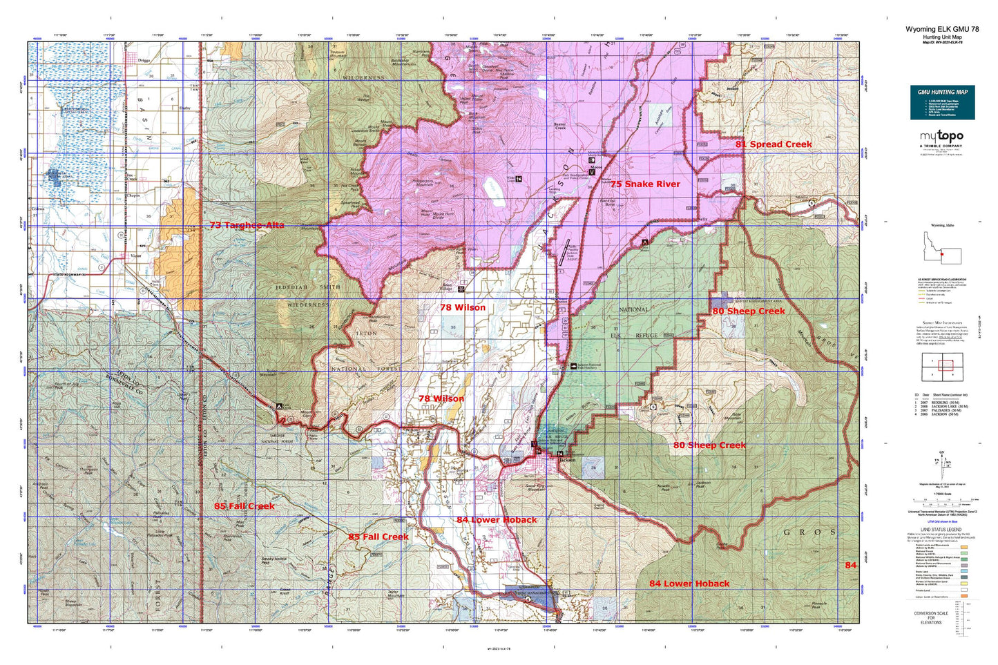
Wyoming Elk GMU 78 Map
Couldn't load pickup availability
Hunting unit map of Wyoming Game Management Unit ELK-78 with topographic lines and unit boundaries. This topo map features UTM / MGRS and Latitude/Longitude grids, plus public land ownership. It comes folded on waterproof paper. Be fully prepared for your hunt with a MyTopo GMU map!.
This map contains the following named places: 83014,83025,83428,Adams Canyon,Albright Peak,Allen Creek,Anchor Ranch,Apres Vous Peak,Aspen Ranch,Atkinson Peak,Baldy Knoll,Bear Canyon,Beaver Creek,Beaver Creek Trail,Big Bend,Black Canyon,Black Grove,Blacktail Butte,Blacktail Ponds,Blacktail Ponds Overlook,Blanchard Ridge,Boyles Hill,Buck Mountain,Burbank Creek,Cache Creek,Cache Peak,Carpenter Draw,Chapin,Cherry Grove Canal,City of Victor,Coal Creek,Coal Creek Campground,Coal Creek Meadows,Corral Creek,Cottonwood Creek,Coyote Lake,Crane Creek,Crater Lake,Crescent H Fall Creek Pit Mine,Curtis Canyon,Curtis Canyon Campground,Curtis Canyon Overlook,Darby Canyon,Darby Creek,Darby Girls Camp,Deadwood Creek,Death Canyon,Death Canyon Shelf,Ditch Creek,Dry Creek,Dry Hollow,East Fork Palisades Creek,East Gros Ventre Butte,Elbow Fork,Elk Exhibition Pasture,Elk Gulch,Elliott Creek,Fish Creek,Fogg Hill,Forget-me-not Lakes,Fossil Mountain,Foster Slough,Fourth of July Peak,Fox Creek,Fox Creek East Access Area,Fox Creek West Access Area,Game Creek,Game Creek Trail,Gin Pole Draw,Glacier View Turnout,Glory Slide,Goodwin Lake,Granite Canyon,Granite Canyon Trail,Granite Creek,Green Mountain,Gros Ventre Campground,Gros Ventre Junction,Gros Ventre River,Grovont,Horsethief Canyon,Housetop Mountain,Humble Canal,Hungry Creek,Hunts Corral,Indian Lake,J Y Ranch,Jackson,Jackson Country Square Shopping Center,Jackson Hole,Jackson Hole Country Club,Jackson Hole Ski Area,Jackson Mine,Jackson National Fish Hatchery,Jackson Peak,Jensen Canyon,Kearsley Canal,Kelly,Kimball Canal,Lake Creek,Lee Guard Station,Leeks Canyon,Little Horsethief Canyon,Little Palisades Peak,Little Pine Creek,Long Hollow,Lost Spring Creek,Lower Palisades Lake,Mail Cabin Creek,Marion Lake,Marshall Creek,Melody Ranch,Mesquite Creek,Middle Fork Cut Off Trail,Middle Fork Granite Creek,Middle Fork Phillips Canyon,Mike Harris Camnpground,Mike Harris Creek,Mill Creek,Millers Butte,Moose,Moose Creek,Moose Creek Ranch,Moose Gulch,Moose Junction,Moose Lake,Moose Wilson Road,Mosquito Creek,Mount Bannon,Mount Glory,Mount Hunt,Mount Jedediah Smith,Mount Meek,Mud Lake,Mud Peak,National Elk Refuge,Neeley Cove,Noker Mine Draw,Nordwall Canyon,North Fork Darby Creek,North Fork Game Creek,North Fork Granite Creek,North Fork Mosquito Creek,North Fork Palisades Creek,North Fork Phillips Canyon,North Fork Trail Creek,North Twin Creek,Nowlin Creek,Nowlin Peak,Oliver Peak,Open Canyon,Open Canyon Trail,Palisades Lake Lodge,Palisades Peak,Pass Lake,Phelps Lake,Phillips Canyon,Phillips Canyon Trail,Phillips Ridge,Pink Garter Plaza,Plummer Canyon,Prospectors Mountain,R Lazy S Ranch,Rafter J Ranch,Rendezvous Mountain,Rendezvous Mountain Trail,Rendezvous Peak,Rimrock Lake,Rock Creek,Rock Face,Rock Springs Canyon,Salt Lick Draw,Sheep Creek,Sheep Steps,Sherman Canyon,Ski Lake,Sleeping Indian Pond,Smith Canyon,Smoky Hollow Peak,Snow King Mountain,Sorensen Creek,South Fork Darby Creek,South Fork Game Creek,South Fork Granite Creek,South Park,South Twin Creek,Spearhead Peak,Spencer Canal,Spring Creek,Spud Drive-In,Starvation Peak,Static Peak,Stewart Draw,String Canal,Sturlin and Sperl Mine,Table Mountain,Taggart Creek,Talbot Canyon,Taylor Basin,Taylor Creek,Taylor Mountain,Taylor Mountain Trail,Terrace Creek,Teton Basin,Teton Crest Trail,Teton Game Management Area,Teton Science School,Teton Valley Ranch,Teton Village,The String,Thompson Peak,Timberline Lake,Tonks Canal,Town of Jackson,Trail Creek,Trail Creek Campground,Trail Creek Ranch,Tucker Pit Mine,Twin Creek Ranch,Upper Palisades Lake,Valley Trail,Victor,Victor Division,Warm Creek,Warm Springs Ranch,Waterfall Creek,Weir,West Burbank Creek,West Gros Ventre Butte,White Grass Ranch,White Grass Ranger Station,Wilson,Wilson South Pit and Plant Mine,Windy Point Turnout,Woods Canyon


