MyTopo
Wyoming Elk GMU 81 Map
Couldn't load pickup availability
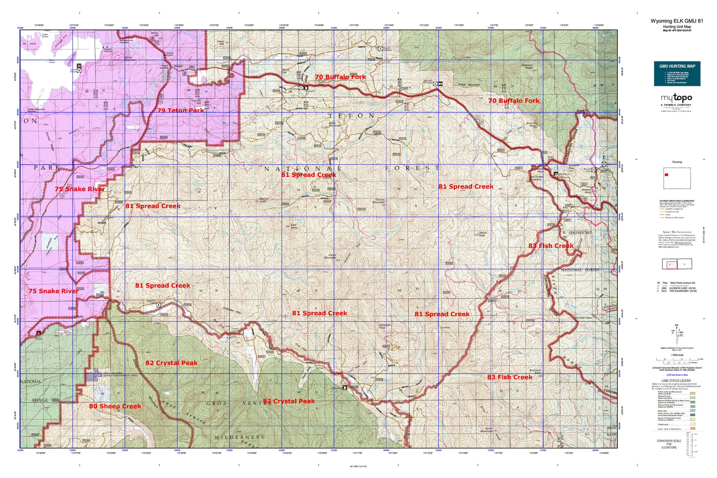
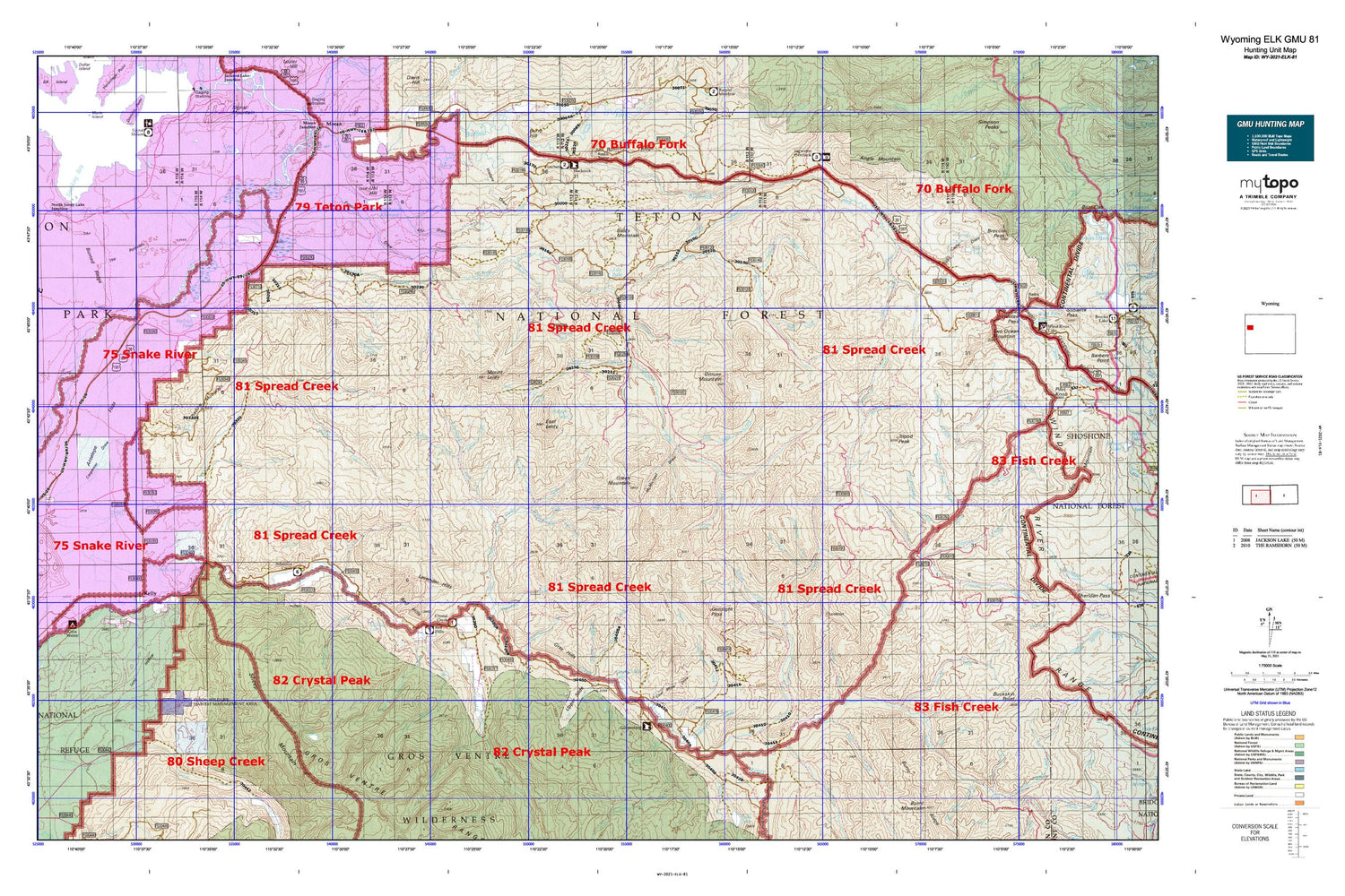
Hunting unit map of Wyoming Game Management Unit ELK-81 with topographic lines and unit boundaries. This topo map features UTM / MGRS and Latitude/Longitude grids, plus public land ownership. It comes folded on waterproof paper. Be fully prepared for your hunt with a MyTopo GMU map!.
This map contains the following named places: 3R Mine,Alkali Creek,Angle Mountain,Angles Trailhead,Antelope Flats,Antelope Spring,Aspen Creek,Atherton Creek,Atherton Creek Campground,Bacon Creek,Baldy Mountain,Bear Paw Fork,Beauty Park,Beauty Park Creek,Bell Creek,Bierer Creek,Black Rock Meadows Mine,Blackrock Meadows,Blackrock Ranger District Office,Blackrock Ranger Station,Blue Miner Lake,Breakneck Creek,Breakneck Flat,Bridger - Teton National Forest Blackrock - Buffalo Ranger District Fire Engine Crew,Brush Creek,Bull Creek,Bull Creek Patrol Cabin,Burnt Creek,Burnt Ridge,Cabin Creek,Calf Creek,Carmichael Fork,Cavy Creek,Coal Creek,Coal Mine Draw,Cottonwood Creek,Cowboy Lode Mine,Crows Nest Creek,Crystal Creek,Crystal Creek Campground,Cunningham Cabin,Dallas Creek,Dallas Fork,Dallas Lake,Deadmans Bar,Deer Creek,Deer Creek Lookout,Deer Creek Mountain,Devils Dip Creek,Dog Creek,Dry Cottonwood Creek,Dry Dallas Creek,Dry Gulch,Dry Hollow,Dry Lake,Dry Lake Creek,East Leidy,East Miner Creek,Elk,Elk Ranch Reservoir,Elkhorn Creek,Eynon Draw,Falcona Claims Mine,Falls Creek,First Gulch,Fish Creek,Flagstaff Creek,Fourmile Meadow,Fourmile Meadow Picnic Area,Goosewing Creek,Goosewing Guard Station,Gray Hills,Green Mountain,Grizzly Creek,Grizzly Lake,Gros Ventre Campground,Gros Ventre Overlook,Gros Ventre Slide Geological Area,Grouse Creek,Grouse Mountain,Grovont,Gunsight Pass,Hackamore Creek,Halfmoon Lake,Hardeman Dam,Hardeman Reservoir,Hardemann Reservoir,Hardiman Number 2 Dam,Hardscrabble Creek,Harness Gulch,Hatchet Campground,Haystack Fork,Hedrick Pond,Hereford Creek,Hidden Lake,Horsetail Creek,I W W Creek,Iter Gross Ventre Mine,Jackson Hole Division,Kelly,Kelly Cemetery,Kelly Census Designated Place,Kelly Post Office,Kelly School,Kelly Warm Spring,Kettle Creek,Lake Creek,Larkspur Creek,Lava Creek,Lavender Hills,Leidy Creek,Leidy Lake,Lightning Creek,Lily Lake,Little Bear Paw Fork,Little Sohare Creek,Long Hollow,Lost Creek,Lost Creek Ranch,Lost Lake,Lower Slide Lake,Marys Lake,Maverick Creek,McMichael Draw,Middle Fork Ditch Creek,Moose Head Ranch,Moosehorn Creek,Mount Leidy,Mount Moran Scenic Turnout,Nation Creek,Negrohead Fork,North Fish Creek Trail,North Fork Ditch Creek,North Fork Fish Creek,North Fork Spread Creek,Open Fork,Packsaddle Creek,Papoose Creek,Pill Creek,Poison Creek,Porter Dam,Porter Reservoir,Preacher Park,Purdy Basin,Purdy Basin Trail,Purdy Creek,Red Creek,Red Hills,Red Hills Campground,Red Rock Ranch,Redmond Creek,Road Camp Draw,Rock Creek,Sagebrush Flat,Second Gulch,Shadow Mountain,Sheep Mountain,Shorty Creek,Skull Creek,Skull Creek Meadows,Slate Creek,Snake River Headwaters Wild and Scenic River,Snake River Overlook,Soda Creek,Sohare Creek,South Fork Ditch Creek,South Fork Fish Creek,South Fork Spread Creek,South Landing,Spalding Bay,Split Rock Creek,Spread Creek,Spruce Creek,Squaw Basin,Squaw Creek,Starvation Creek,Steep Creek,Tent Creek,Tepee Creek,Teton Game Management Area,Teton National Forest,Teton Point Turnout,Teton Science School,Teton Valley Ranch,The Potholes,Togwatee Overlook,Togwotee Lodge,Toppings Lakes,Trail Creek,Triangle X Ranch,Tripod Creek,Tripod Peak,Turpin Creek,Two Water Creek,Uhl Dam,Uhl Draw,Uhl Hill,Uhl Reservoir,Upper Slide,Upper Slide Lake,Wallace Draw,Wallace Draw-Reservoir,West Fork Horsetail Creek,West Miner Creek,Wolf Gulch,Wolff Ranch,Yellowjacket Creek,Yellowjacket Flat