
MyTopo
Wyoming Elk GMU 90 Map
Couldn't load pickup availability
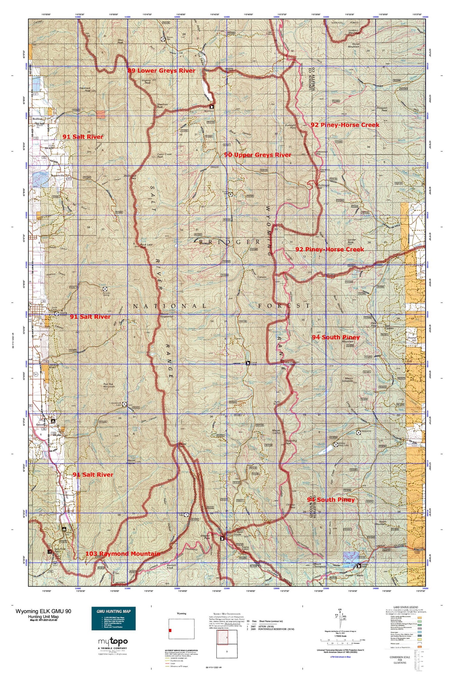
Hunting unit map of Wyoming Game Management Unit ELK-90 with topographic lines and unit boundaries. This topo map features UTM / MGRS and Latitude/Longitude grids, plus public land ownership. It comes folded on waterproof paper. Be fully prepared for your hunt with a MyTopo GMU map!.
This map contains the following named places: 83110,83112,83126,Afton Creek Mine,Afton Division,Alpine Mine,Anderson Creek,Bare Mountain,Bare Pass,Bear Creek,Beartrap Junction,Black Canyon,Blind Bull Creek,Blind Bull Lake,Blind Bull Mine,Boco Creek,Box Canyon Creek,Box Canyon Pass,Box Y Ranch,Bridger National Forest,Broad Canyon,Broad Hollow,Buck Creek,Bug Creek,Burney Canyon,Cabin Creek,Cabin Creek Peak,Cabin Creek Peak Lookout Tower,Chair Creek,Chase Creek,Cheese Pass,Churchhouse Hollow,Clear Creek,Coal Mine Mountain,Corlos Creek,Corral Creek,Corral Creek Guard Station,Corral Creek Lake,Cottonwood Lake,Cottonwood Lake Campground,Cottonwood Lake Dam,Cottonwood Mine,County Creek,Crow Creek,Crow Creek Lakes,Crystal Lake,Crystal Lake Recreation Site,Dead Cow Creek,Deadhorse Creek,Deadman Creek,Dick Creek,Dry Basin Creek,Dry Canyon,Dry Canyon Mine,Dry Creek Lake,Eagle Creek,East Fork Greys River,Elk Creek,Fish Creek,Fish Creek Mountain,Flat Creek,Forest Dell,Forest Park Campground,Forest Park Elk Wintering Area,Foster Meadows,Gomm Hollow,Grover Park,Gunsight Pass,Hardin Creek,Haystack Peak,Henderson Creek,Hidden Basin Creek,Horse Creek Mine,Horse Mountain,Irene Creek,Kinney Creek,Kleinstick Mine,Lake Barstow,Lake Creek,Lake Fork Creek,Lander Creek,Lander Peak,Leefe Mine,Lewis Falls,Little Blind Bull Creek,Long Hollow,Lookout Creek,Lower Cabin Creek,Lunch Creek,Lunch Creek Meadows,Man Peak,Marges Delight Creek,Marten Creek,McDougal Creek,McDougal Pass,McDouglas Pass Mine,Meadow Creek,Meadow Creek Guard Station,Meadows Forest Service Facility,Menace Falls,Middle Fork North Fish Creek,Middle Piney Dam,Middle Piney Lake,Middle Piney Lake Campground,Middle Piney Reservoir,Middle Piney Summer Home Area,Middle Three Forks Creek,Mill Hollow,Mink Creek,Moffat Creek,Moose Flat,Moose Flat Campground,Mount Coffin,Mount Fitzpatrick,Mount McDougal,Mount Schidler,Mount Wagner,Mud Gulch,Mud Hollow,Mud Lake,Mule Creek,New Cottonwood Mine,North Clear Creek,North Corral Creek,North Crow Creek,North Fork Cottonwood Creek,North Fork Fish Creek,North Fork Sheep Creek,North Fork Strawberry Creek,North Fork Swift Creek,North Fork Willow Creek,North Mountain,North Piney Lake,North Piney Meadows,North Three Forks Creek,North Twin Creek,Nylander Creek,Old Blind Bull Mine,Ole Creek,Olsen Creek,Park Creek,Pearson Creek,Periodic Spring,Peroidic Spring Recreation Site,Pinion Creek,Poison Creek,Poison Creek Mine,Poison Meadows,Porcupine Creek,Prospect Canyon,Prospect Peak,Quaking Aspen Hollow,Red Castles,Red Creek,Red Top Creek,Red Top Mountain,Ridge Creek,Roaring Fork,Roaring Fork Lakes,Rock Creek,Rock Lake,Rock Lake Peak,Rowdy Creek,Sacajawea Campground,Salt River Range,Scout Canyon,Shale Creek,Sheep Creek,Sheep Creek Canyon Mine,Sheep Creek Divide Mine,Sheep Pass,Sherman Peak,Shot Hole Spring,Sjhoberg Creek,Slide Canyon,Slide Lake,Smith Mine,Snowdrift Creek,Soda Lake,South Apperson Creek,South Crow Creek,South Fork Bare Creek,South Fork Meadow Creek,South Fork North Horse Creek,South Fork South Cottonwood Creek,South Three Forks Creek,South Three Forks Lakes,South Twin Creek,Spring Creek,Spring Creek Falls,Steves Canyon,Straight Creek,Swift Creek Lake,The Elbow,Tie-Hack Cabins,Timber Creek,TKC Claims,Trail Creek,Trail Fork,Trailer Creek,Triple Peak,Triplet Vents,Turnerville Cemetery,Upper Cabin Creek,Virginia Peak,Visser Peak,Wagner Creek,Wagner Lake,Walker Creek,West Fork Bare Creek,West Fork Greys River,West Mine,Willow Creek,Wohelo Falls,Wyoming Peak,Wyoming Range,Wyoming Range Trail,Y Canyon,Young Canyon,Young Spring


