MyTopo
Wyoming Elk GMU 93 Map
Couldn't load pickup availability
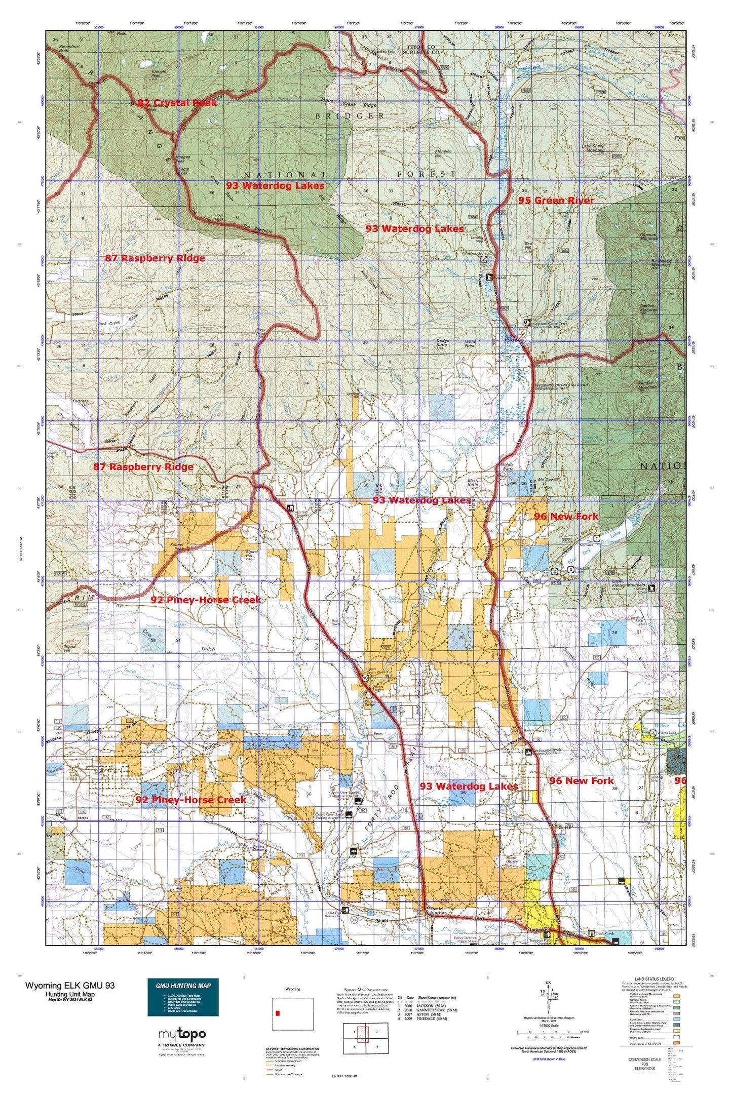
Hunting unit map of Wyoming Game Management Unit ELK-93 with topographic lines and unit boundaries. This topo map features UTM / MGRS and Latitude/Longitude grids, plus public land ownership. It comes folded on waterproof paper. Be fully prepared for your hunt with a MyTopo GMU map!.
This map contains the following named places: Alexander Family Cemetery,Annie Draw,Apex Ditch,Apex Pit,Ashley Wolf Ditch,Aspen Ridge,Badger Creek,Bar Cross Ranch,Bartlett Creek Area Mine,Beaver Creek,Beaver Dam Draw,Bickel Ditch,Big Bend,Big Twin Creek,Black Butte,Blackrock Ranger District,Boulder Basin Trail,Boulder Creek,Brewster Lake,Bronx,Brook Lake,Buds Pit Mine,Cabin Draw,Canyon Ditch,Circle S Ranch,Cora,Cora Census Designated Place,Cora Pit,Cora Post Office,Cow Gulch,Coyote Basin,Crooked Creek,Culbertson Creek,Dago Creek,Daylite Pit Mine,Dickinson Number 1 Ditch,Dodge Butte,Dodge Ditch,Dollar Lake,Doubletop Peak,Dumphy Hollow,Eagle Creek,Eagle Peak,East Rim,Elbow Draw,Elk Ridge,Extension Dickinson Ditch,F Bar Cross Seventy-six Mine,Fisherman Creek Lake,Fisherman Pit Mine,Five Eighty-two Pit Number Two Mine,Five Thirty-two Pit Number One Mine,Flying A Ranch,Forty Rod Flat,Forty Rod Flat Well,Forty Rod North Mine,Forty Rod Pit,Forty Rod Reservoir,Franz Pit Mine,Franz Reservoir,Graham Ditch,Graveyard Pit,Gypsum Creek,Gypsum Creek Mine,Gypsum Hill,Gypsum Park,Gypsum Spring,Haas Airport,Hay Gulch,Hodges Peak,Horsefly Ditch,Indian Graves,Jack Creek Basin,Jack Creek Spring,Jakes Pit Mine,Jenkins Ditch,Jim Creek,Johnson Pit Mine,Josephine Ditch,Kendall Guard Station,Kendall Valley Fire Battalion,Kendall Warm Spring,Kim Rush Park,Kismet Peak,Kitchen Dam,Kitchen Reservoir,Klondike Creek,Klondike Hill,L L Pit Mine,Lake Creek,Lauzer Fish Pond Reservoir,Lead Creek,Lena Ditch,Lime Creek,Little Flattop Mountain,Little Sheep Mountain,Little Twin Creek,Loomis Park,Lot Two Pit Mine,Lower Boulder Basin,Marsh Creek,Marsh Creek Pit Mine,McDowell Flat,Middle Beaver Creek,Middle Butte,Miner Creek,Miner Pit Mine,Moore Ranch,Moose Creek,Mud Creek,New Fork Lake,New Fork Lake Dam,New Fork Lakes,New Fork Lakes Campground,New Fork Lookout Point,New Fork Scout Camp,New York Campground,Noble Pit,North Beaver Creek,North Fork Middle Beaver Creek,North Pape Pit,Old Warren Bridge,Ole Cabin Creek,Packer Creek,Pape Pit,Pass Peak,Pine Grove Ditch,Pinedale Division,Pixley Creek,Pocket Pit Mine,Porcupine Creek,Pot Creek,Pot Creek Park,Pot Creek Trail,Quarter Corner Pit Mine,Que Pit Mine,Rahm Ditch,Raspberry Ridge,Red Creek,Red Hill,Red Hills,Rexs Pit Mine,Rim Draw,Rim Draw Mine,Roaring Fork,Rock Creek,Rock Creek Buttes,Rocky Draw,Sandrock Creek,Sawmill Park Trail,Scott Ditch,Signal Hill,Sink Hole Pit Mine,Sled Runner Creek,Slide Creek,Sour Moose Creek,South Beaver Creek,South Fork Gypsum Creek,South Fork Middle Beaver Creek,Spring Creek,Stinky Spring,Sunset Dam,Sunset Reservoir,Tepee Creek,Tepee Creek Ridge,The Elbow,The Narrows,The Narrows Campground,The Rim,The Sawtooth,Tie Camp Cemetery,Tosi Creek,Tosi Creek Area Mine,Tosi Creek Basin,Tosi Creek Basin Mine,Tosi Creek Prospects Mine,Tosi Peak,Triangle Peak,Twin Creek Basin,Wagon Creek,Wagonfeur Creek,Wardell Pit Mine,Warm Spring,Warm Springs Trail,Warren Bridge,Water Dog Lakes,Watson Draw,West Dell Creek,West Dell Falls,Westfall - Cora Cemetery,Whiskey Creek,Whiskey Grove Campground,White Point,Wimple Pit