MyTopo
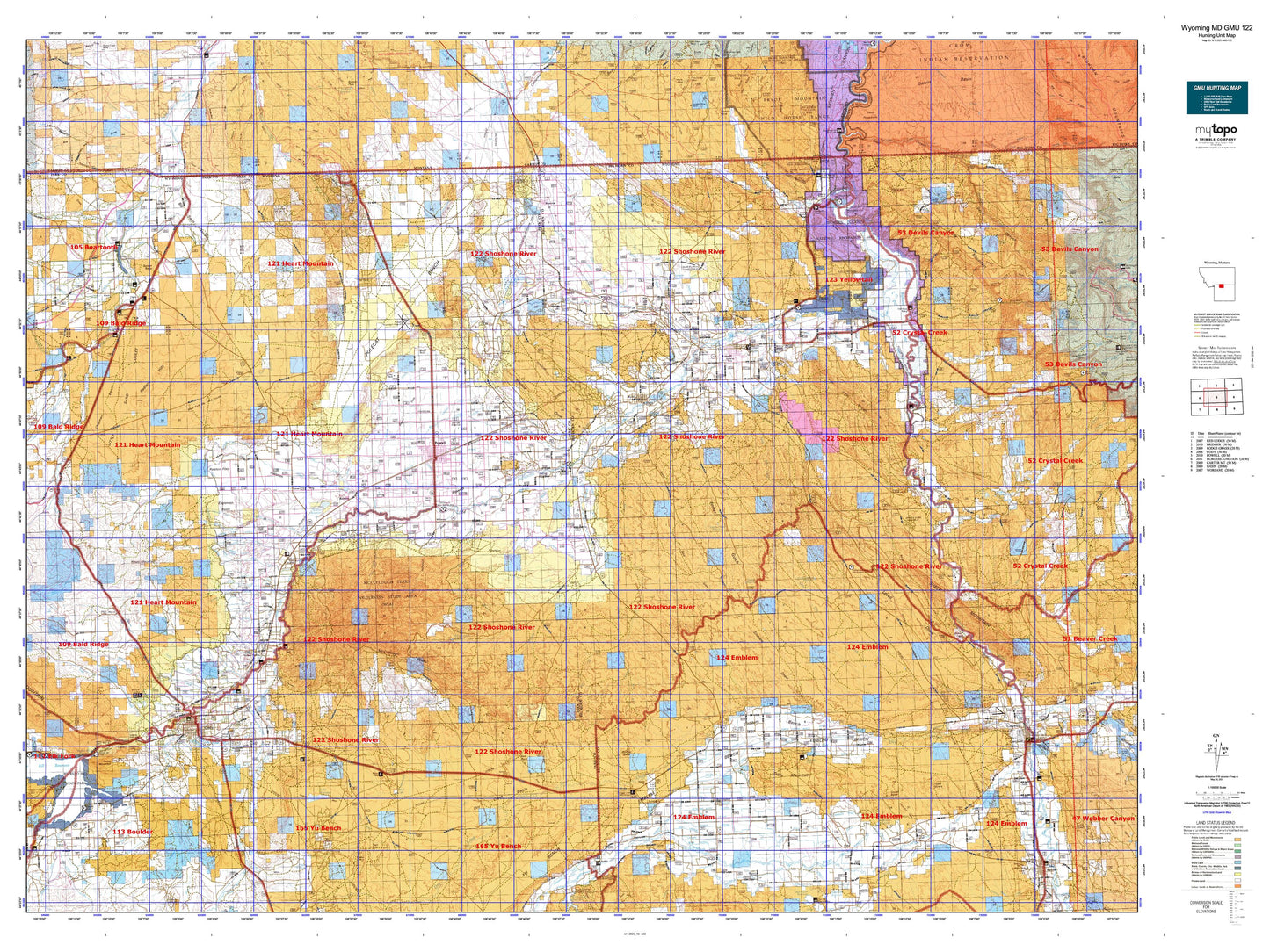
Wyoming Mule Deer GMU 122 Map
Couldn't load pickup availability
Hunting unit map of Wyoming Game Management Unit MD-122 with topographic lines and unit boundaries. This topo map features UTM / MGRS and Latitude/Longitude grids, plus public land ownership. It comes folded on waterproof paper. Be fully prepared for your hunt with a MyTopo GMU map!.
This map contains the following named places: 82411,82412,82420,82421,82422,82423,82431,82435,82440,Agrarian Ditch,Alkali Creek Patch,Alkali Creek Reservoir,Alkali Lake,Anna May Ditch,Back Scratcher Reservoir,Badger Basin,Badland Hills,Bahr Lateral,Bank Lateral,Bar Hill,Bear Creek,Beck and Allen Lateral,Beck Lake,Bench Canal Reservoir,Bennett Creek,Bennett Creek Ditch,Bethurem Reservoir,Big Fork Canal,Bighorn Basin,Bighorn Lake,Bischoff Creek Reservoir,Bishop Cow Camp,Bitter Creek,Blue Lake,Bridger Butte,Buck Creek,Buck Springs Creek,Buck Springs Reservoir,Burlington,Buttercup Reservoir,Byron,Caesar Reservoir,Cat Track Reservoir,Cedar Buttes Reservoir,Cedar Ridge Reservoir,Central Big Horn Division,Chance,Chapman Bench,Chesarek Ranch,City of Cody,City of Powell,City Reservoir,Clark,Clark Ditch,Cleopatra Reservoir,Coal Creek,Cody,Cody Lateral Ditch,Cody Municipal Reservoir,Coon Creek,Cottonwood Creek,Cowley,Cowley Siding,Crazy Quilt Reservoir,Crooked Creek,Crystal Creek,Deaver,Deaver Canal,Deaver Reservoir,Deer Creek,Delbert Jones Reservoir,Devils Canyon Overlook,Devils Playground,Dew and Duffield Ditch,Diamond Creek,Dilworth Creek,Ditch H-16,Ditch H-24,Ditch H-28,Ditch H-33,Ditch H-41,Ditch H-57,Dorsey Creek,Dry Creek,Eaglenest,Eaglenest Basin,Eaglenest Creek,East Fork Alkali Creek,East Reservoir,Eastgate Shopping Center,Eberhard Ranch,Elk Basin,Emblem,Emblem Bench,Emma Lanchbury Reservoir,Fenton,Fenton School,Five Springs Creek,Frannie,Garland,Garrett Ranch,Garvin Basin,Gilmore Hill,Gould Butte,Grabbert Corral,Grass Creek,Gyp Reservoir,Gypsum Creek,Heart Mountain,Himes,Hopkins Reservoir,Horse Creek,Horseshoe Reservoir,Hump Reservoir,Idaho Creek,Iron Creek,Iron Creek Reservoir,Jack Horner Reservoir,Jensons Pond,Jim Bridger Trail,Jolley Reservoir,Jolly Reservoir,Kamms Corner,Kane,Karate Reservoir,Katys Nipple,Lake McKinney,Lanchbury Ranch,Lewellen Ranch,Line Creek,Linquist Ranch,Little Dry Creek,Little Mountain,Little Polecat Creek,Little Sheep Mountain,Littlerock Creek,Loch-Katrine Bird Reservation,Lone Hill Reservoir,Lone Tree Crossing,Lovell,Lovell Lakes,Lower Sand Coulee Reservoir,Lundvall Ranch,Mantua,Markham Reservoir,Marlow Ranch,McCullough Peaks,McKinnie Creek,McKinnie Reservoir,McLean Gulch Reservoir,Middle Sand Coulee Reservoir,Miles Battlefield,Moss Ranch,Mud Spring Cabin,Natural Corrals,Newton Lakes,Noble Ranch,North Alkali Creek,North Big Horn Division,North Branch Whistle Creek,North Emblem Reservoir,North Fork Cottonwood Creek,North Fork Dry Creek,North Snyder Reservoir,Oasis Spring Creek,O'Donnell,Oregon Basin,Otto,Owens Ranch,Pass Reservoir,Pat O'Hara Creek,Penney Peak,Perkins Bottom,Peterson Creek,Polecat Bench,Polecat Creek,Porcupine Creek,Powell,Powell Division,Question Creek,Ralston,Ralston Reservoir,Red Butte,Rock Reservoir,Rolston Reservoir,Sage Creek,Saver Reservoir,Scribner Junction,Shoshone River,Snake Creek,Snyder Reservoir,Sore Finger Reservoir,South Eaglenest Creek,South Fork Coon Creek,Spence,Spring Creek,Stafford Ranch,Stone Barn Camp,Stucco,Sugarloaf Butte,Sulphur Creek,Sykes Mountain,Table Mountain,Teeples Reservoir,Thayer Ranch,The Narrows River,Three Falls Reservoir,Tillett Ranch,Tommy Tucker Reservoir,Town of Burlington,Town of Byron,Town of Cowley,Town of Deaver,Town of Frannie,Town of Lovell,Trail Creek,Trask Ranch,Trigood Reservoir,Trotters Station,Trout Creek,Upper Sand Coulee Reservoir,Vocation,Walker Ranch,West Branch Whistle Creek,West Fork Alkali Creek,West Fork Coon Creek,West Fork Sand Coulee Reservoir,Whistle Creek,Whistle Creek Reservoir,White Reservoir,Wiley,Wiley Lake,Willow Creek,Willwood,Yellow Hill