
MyTopo
Wyoming Mule Deer GMU 155 Map
Couldn't load pickup availability
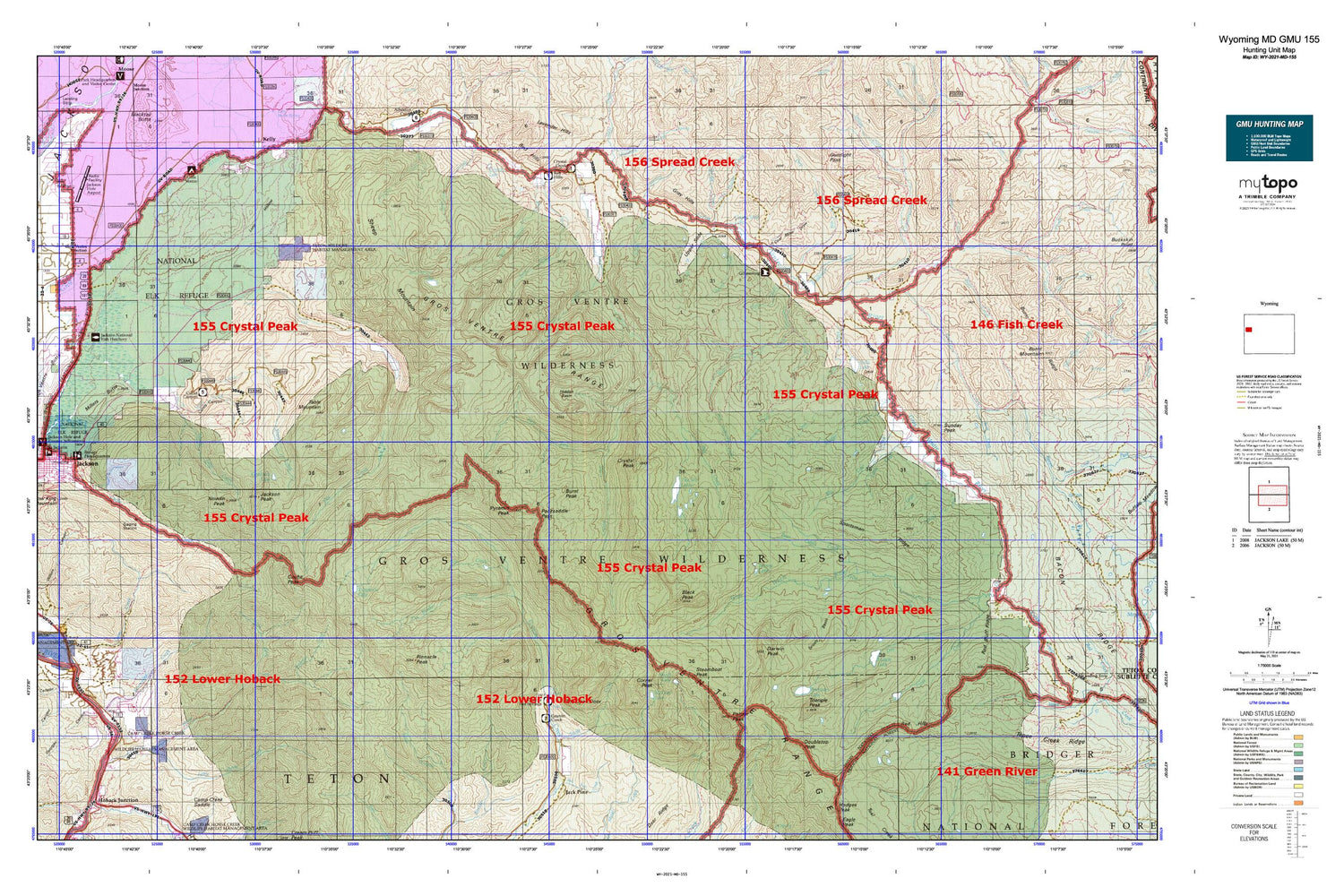
Hunting unit map of Wyoming Game Management Unit MD-155 with topographic lines and unit boundaries. This topo map features UTM / MGRS and Latitude/Longitude grids, plus public land ownership. It comes folded on waterproof paper. Be fully prepared for your hunt with a MyTopo GMU map!.
This map contains the following named places: 83001,83011,Abercrombie Warm Springs,Alkali Creek,Alkali Gulch,Antoinette Peak,Bacon Creek,Bang Creek,Bear Cabin Creek,Big Cow Creek,Black Peak,Blackman Creek,Blue Miner Lake,Box Creek,Box Lake,Breakneck Creek,Breakneck Flat,Brewster Lake,Bridge Creek,Bunker Creek,Burnt Creek,Burnt Point,Cache Peak,Chateau Lake,Clear Creek,Coal Mine Draw,Coles Canyon,Corner Peak,Cottonwood Creek,Cowboy Camp,Crystal Creek,Crystal Creek Campground,Crystal Peak,Curtis Canyon,Curtis Canyon Campground,Curtis Canyon Overlook,Dallas Creek,Dallas Lake,Darwin Peak,Deer Creek,Deer Creek Lookout,Deer Creek Mountain,Dells Canyon,Devils Dip Creek,Dog Creek,Doubletop Peak,Dry Cottonwood Creek,Dry Dallas Creek,Dry Fork Clear Creek,Dry Hollow,East Miner Creek,Elk Exhibition Pasture,Falcona Claims Mine,Farney Lakes,Fish Creek,Flat Creek,Flat Creek Ranch,Georges Canyon,Gin Pole Draw,Goodwin Lake,Goosewing Creek,Goosewing Guard Station,Granite Creek Campground,Granite Falls,Granite Falls Hot Springs,Granite Highline Trail,Granite Hot Springs,Granite Hot Springs Mine,Gray Hills,Grizzly Basin,Grizzly Lake,Gros Ventre Campground,Gros Ventre Junction,Gros Ventre Range,Gros Ventre Wilderness,Gunsight Pass,Haystack Fork,Hidden Basin,Horn Ranch,Horse Creek,Horsethief Canyon,Hot Spring,Iter Gross Ventre Mine,Jackson Hole Airport,Jackson Hole Airport Fire Department,Jackson Mine,Jackson National Fish Hatchery,Jackson Peak,Jagg Creek,Jones Creek,Lafferty Creek,Lake Creek,Lightning Creek,Little Cow Creek,Little Grizzly Basin,Little Horse Creek,Little Sohare Creek,Lloyd Creek,Long Hollow,Lunch Lake,Mac Leod Lake,Millers Butte,Millers Springs,Mud Creek,National Elk Refuge,National Museum of Wildlife Art of the United States,Noker Mine Draw,North Fork Fish Creek,North Fork Horse Creek,North Twin Creek,Nowlin Creek,Nowlin Peak,Ouzel Falls,Packsaddle Pass,Palmer Peak,Peterson Springs,Pinnacle Peak,Poison Creek,Pond Creek,Porcupine Creek,Pyramid Peak,Red Bluff Ridge,Red Hills,Red Hills Campground,Red Rock Ranch,Reynolds Mine,Salt Lick Draw,Sheep Creek,Sheep Mountain,Shoal Falls,Shoal Lake,Shorty Creek,Slate Creek,Sleeping Indian Pond,Soda Creek,Soda Lake,Sohare Creek,South Fork Fish Creek,South Twin Creek,Sportsman Ridge,Squaw Creek,Steamboat Peak,Sturlin and Sperl Mine,Sunday Peak,Swift Creek,Table Mountain,Tepee Creek,Teton Game Management Area,The Meadows,The Open Door,The Six Lakes,Trail Creek,Triangle Peak,Turquoise Lake,Twin Creek Ranch,Two Echo Park,Upper Falls,Upper Slide,Upper Slide Lake,Warm Springs Ranch,Water Gulch,West Dell Falls,West Fork Crystal Creek,West Goosewing Creek,West Miner Creek,Wolf Gulch,Woods Canyon,Wyoming Highway Patrol District 3 Division K,Yellowjacket Creek,Yellowjacket Flat


