MyTopo
Wyoming Mule Deer GMU 162 Map
Couldn't load pickup availability
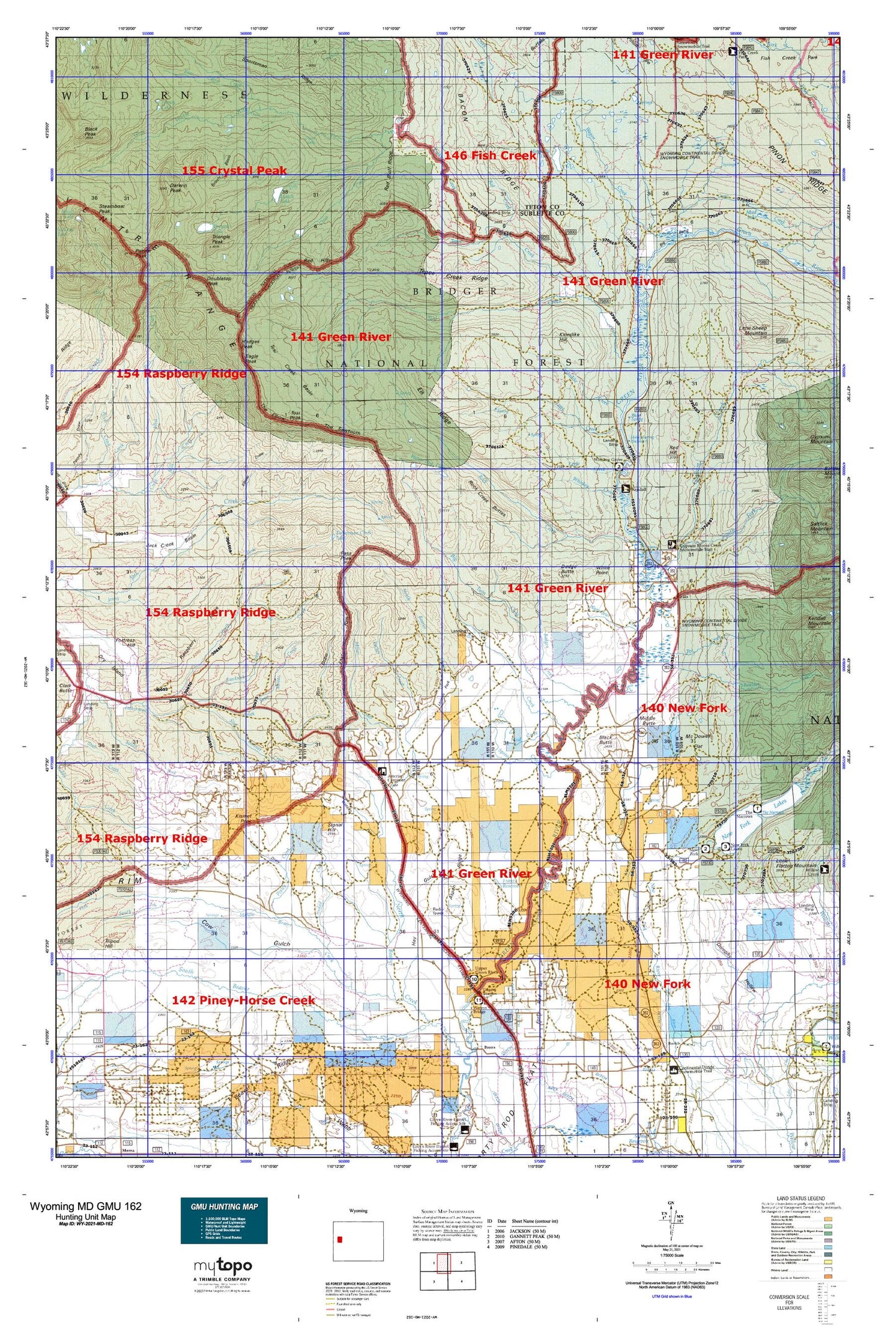
Hunting unit map of Wyoming Game Management Unit MD-162 with topographic lines and unit boundaries. This topo map features UTM / MGRS and Latitude/Longitude grids, plus public land ownership. It comes folded on waterproof paper. Be fully prepared for your hunt with a MyTopo GMU map!.
This map contains the following named places: Alexander Family Cemetery,Annie Draw,Aspen Ridge,Bacon Ridge,Badger Creek,Bartlett Creek Area Mine,Bear Cabin Creek,Beaver Dam Draw,Bickel Ditch,Big Bend,Big Twin Creek,Black Butte,Blackrock Ranger District,Boulder Creek,Brewster Lake,Buds Pit Mine,Cabin Draw,Canyon Ditch,Chateau Lake,Circle S Ranch,Clear Creek,Cow Gulch,Coyote Basin,Crooked Creek,Crow Creek,Culbertson Creek,Dago Creek,Darwin Peak,Darwin Ranch,Daylite Pit Mine,Dodge Butte,Dollar Lake,Doubletop Peak,Dry Fork Clear Creek,Dumphy Hollow,Eagle Creek,Eagle Peak,East Rim,Elbow Draw,Elk Ridge,Farney Lakes,Fisherman Creek,Fisherman Creek Lake,Fisherman Pit Mine,Five Eighty-two Pit Number Two Mine,Five Thirty-two Pit Number One Mine,Flying A Ranch,Fortress Hill,Forty Rod Flat Well,Franz Pit Mine,Franz Reservoir,Grizzly Basin,Gros Ventre Range,Gypsum Creek,Gypsum Hill,Gypsum Spring,Haas Airport,Hay Gulch,Hodges Peak,Horsefly Ditch,Jack Creek Basin,Jack Creek Spring,Jakes Pit Mine,Jim Creek,Johnson Pit Mine,Kendall Guard Station,Kendall Valley Fire Battalion,Kendall Warm Spring,Kim Rush Park,Kinky Creek,Kinky Creek Divide Airport,Kismet Peak,Klondike Creek,Klondike Hill,L L Pit Mine,Lake Creek,Lena Ditch,Lime Creek,Little Grizzly Basin,Little Twin Creek,Loomis Park,Lot Two Pit Mine,Lower Boulder Basin,Lunch Lake,Marsh Creek,Marsh Creek Pit Mine,McDowell Flat,Middle Beaver Creek,Middle Butte,Mill Creek,Miner Creek,Miner Pit Mine,Moore Ranch,Moose Creek,Mosquito Lake,Mud Creek,Mud Lake,New Fork Lake,New Fork Lake Dam,New Fork Lakes,New Fork Lakes Campground,New Fork Lookout Point,New Fork Scout Camp,New York Campground,North Beaver Creek,North Fork Fisherman Creek,North Fork Middle Beaver Creek,Ole Cabin Creek,Ouzel Falls,Packer Creek,Palmer Peak,Pass Peak,Pine Grove Ditch,Pinedale Division,Pixley Creek,Pocket Pit Mine,Porcupine Creek,Pot Creek,Pot Creek Park,Pot Creek Trail,Quarter Corner Pit Mine,Que Pit Mine,Raspberry Ridge,Red Bluff Ridge,Red Creek,Red Hill,Red Hills,Rexs Pit Mine,Rim Draw,Rim Draw Mine,Rock Creek,Rock Creek Buttes,Rocky Draw,Sandrock Creek,Sawmill Park Trail,Signal Hill,Sink Hole Pit Mine,Sled Runner Creek,Slide Creek,Sour Moose Creek,South Beaver Creek,South Fork Gypsum Creek,South Fork Middle Beaver Creek,South Rim,Spring Creek,Stinky Spring,Tepee Creek,Tepee Creek Ridge,The Elbow,The Narrows,The Narrows Campground,The Rim,The Sawtooth,Tie Camp Cemetery,Tin Can Park,Tosi Creek,Tosi Creek Area Mine,Tosi Creek Basin,Tosi Creek Basin Mine,Tosi Creek Prospects Mine,Tosi Peak,Triangle Peak,Twin Creek Basin,Upper Falls,Wagon Creek,Wagonfeur Creek,Wardell Pit Mine,Warm Spring,Warm Springs Trail,Warren Bridge,Water Dog Lakes,Watson Draw,West Dell Creek,West Dell Falls,Whiskey Creek,Whiskey Grove Campground,White Point