
MyTopo
Wyoming Mule Deer GMU 168 Map
Couldn't load pickup availability
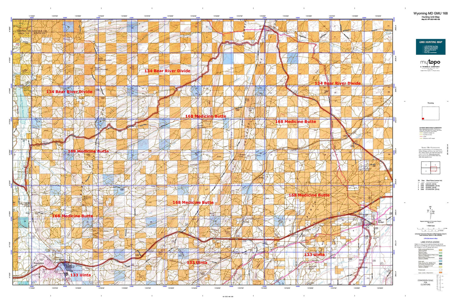
Hunting unit map of Wyoming Game Management Unit MD-168 with topographic lines and unit boundaries. This topo map features UTM / MGRS and Latitude/Longitude grids, plus public land ownership. It comes folded on waterproof paper. Be fully prepared for your hunt with a MyTopo GMU map!.
This map contains the following named places: Acocks Canyon,Adin Brown Ditch,Alkali Creek,Almy,Almy Cemetery,Almy Number Five Mine,Almy Number Forty-one Mine,Almy Number Four Mine,Almy Number One Mine,Almy Number Seven Mine,Almy Number Six Mine,Almy Number Thirty-one Mine,Almy Number Three Mine,Almy Number Two Mine,Antelope,Antelope Creek,Aspen School,Bald Knoll,Bartlett Hollow,Bear River,Bell Butte,Bigelow Bench Reservoir,Bigelow Ditch,Bigelow Springs,Bridger,Bridger Butte,Bridger Butte Canal,Bridger Gap,Broadbent Number 2 Dam,Broadbent Number 2 Reservoir,Byrne Creek,Byrne Ditch Number 2,Byrnes Crossing,Byrnes Draw,Carter Cedars,Chesney Dam,Chesney Reservoir,Christensen Ditch,Christensen Hollow,City Cemetery,Clark School,Clear Creek,Coal Mine Draw,Cottonwood Creek,Cottonwood Dam,Cottonwood Hollow,Cottonwood Reservoir,Crompton Dam,Crompton Ditch,Crompton Reservoir,Crompton Spring,Cumberland Flats,Cumberland Gap Mine,Davis Middle School,Davis Mine,Davis Number 2 Dam,Davis Number 2 Reservoir,Dog Spring,Dry Canyon,Duncomb Hollow,Emigrant Trail,Evanston,Evanston City Cemetery,Evanston Division,Evanston High School,Evanston Middle School,Evanston Police Department,Evanston Post Office,Felter Creek,Foote Spring,Fowkes Canyon,Fowkes Canyon Creek,Grove Spring,Guild Hollow,Hamblin Park,Hanks Hill,Haystack Draw,Hill Creek,Hinshaw Creek,Jager Oil Prospect,Jakes Mine,Junction Mine,Kendall Mine,KOTB-FM (Evanston),Lake Louise,Lazeart Mine,Lezear Opening Mine,Limekiln Gulch,Little Byrne Creek,Little Dee Creek,Little Hogsback,Long Hollow,Lost Draw,Meadow Draw,Medicine Butte,Middle Fork Fowkes Canyon Creek,Mine Spring,Mineral Springs,Morris Ditch,Mulkay Spring,Musselman Draw,Musselman Springs,Mussleman Creek,North Evanston School,North Fork Fowkes Canyon Creek,North Sheep Mountain,Oasis Ditch,Painter Dam,Painter Number 1 Dam,Painter Number 1 Reservoir,Painter Reservoir,Picnic Hollow,Pine Grove Canal,Pine Ridge,Pioneer Counseling Resource Services Hospital,Pleasant Valley Creek,Ragan,Red Canyon,Red Canyon Creek,Red Rock Fork Salt Creek,Richardson Draw,Richardson Mine,Roadside Spring,Robinson Hollow,Rock Creek,Rock Hollow,Rocky Mountain Care Hospital of Evanston,Round Mountain,Salt Creek,School Section Spring,Scullys Gap,Section 2 Spring,Sheep Draw,Shell Hollow,Shurtleff Creek,Sims Canyon,Soda Hollow,South Draw,South Fork Fowkes Canyon Creek,South Sheep Mountain,Spring Creek,Spring Gap,Spring Hollow,The Boilers,The Hogback,The Hogsback,Thistle Hollow,Thomas Canyon,Three Forks,Toms Draw,Town of Bear River,Tunnel Ditch,Uinta County,Uinta County Fire Protection Evanston Station 1,Uinta County Fire Protection Evanston Station 2,Uinta County Sheriff's Office,Uinta Meadows School,Wasmer Draw,West Musselman Draw,Whitney Canyon,Whitney Canyon Creek,Whitney Creek,Willow Creek,Woodruff Lower Narrows,Woodruff Narrows Dam,Woodruff Narrows Reservoir,Woodruff Upper Narrows,Wyoming State Hospital,Wyoming State Hospital Cemetery Lower,Wyoming State Hospital Cemetery Upper,Yellow Creek


