
MyTopo
Wyoming Mule Deer GMU 169 Map
Couldn't load pickup availability
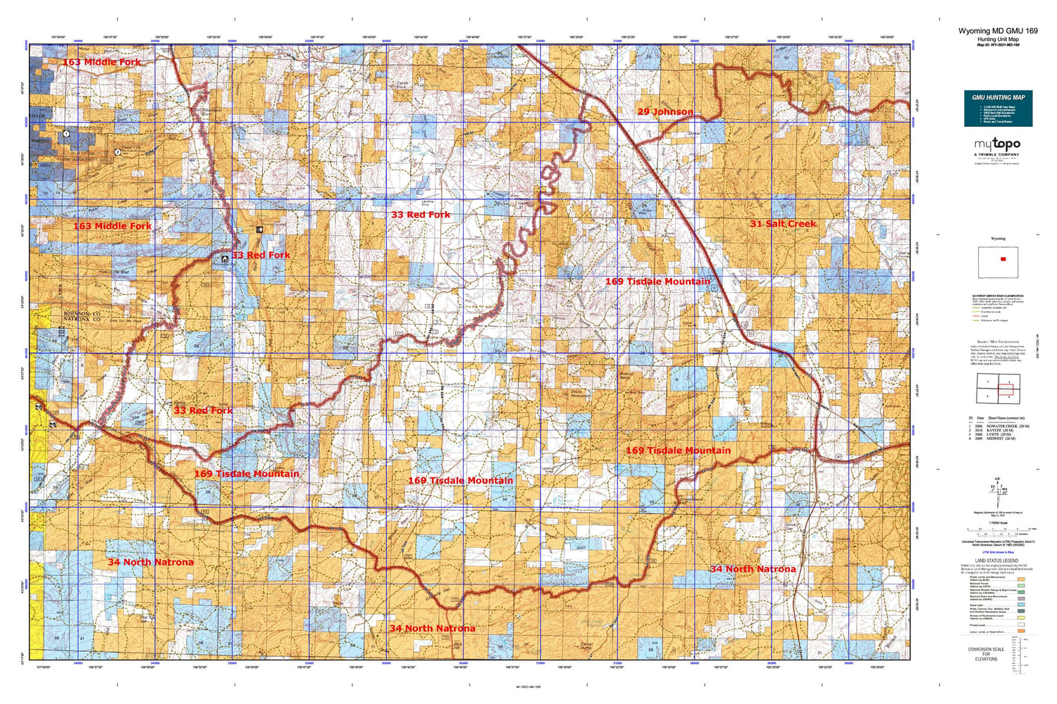
Hunting unit map of Wyoming Game Management Unit MD-169 with topographic lines and unit boundaries. This topo map features UTM / MGRS and Latitude/Longitude grids, plus public land ownership. It comes folded on waterproof paper. Be fully prepared for your hunt with a MyTopo GMU map!.
This map contains the following named places: Albert Number 2 Dam,Albert Number 2 Reservoir,Alkali Creek,Alkali Dam,Alkali Reservoir,Andrus Dam,Andrus Draw,Andrus Reservoir,Antelope Springs,Antelope Springs Ranch,Bar C Draw,Bar C Gap,Bar C Ranch,Bar Spring,Beach Draw,Bedground Draw,Big V Reservoir,Big Willow Creek,Bobcat Basin,Branch Dam,Branch Reservoir,Broken Horn,Broken Horn Creek,Buffalo Creek,Buffalo Creek Ranch,Butts Ranch,Chocolate Reservoir,Cloud Creek,Colonel Dam,Colonel Reservoir,Cottonwood Creek,Cow Spring Butte,Cow Spring Gulch,Dead Horse Creek,Devils Monument,Dry Vee Cabin,Dry Vee Slope,Dry Vee Windmill,Eagle Canyon,Eagle Creek,Eagle Creek Parks,East Tisdale Oil Field,Ellis Dam,Ellis Reservoir,Fiftymile Flat,Firnekas Dam,Firnekas Reservoir,Fitzpatrick Draw,Frewens Castle,Frewens Draw,Ghent Homestead,Ghent Parks,Ghent Slope,Gierse Draw,Government Creek,Government Hill,Grass Creek,Greasewood Lake,Hackett Creek,Hackett Spring,Hodge Creek,Hole-in-the-Wall,Hole-in-the-Wall Slope,Hole-in-the-Wall Windmill,Holman Draw,Hot Water Creek,Houck Slope,Hull Draw,Hull Ranch,Irish Lake,Jacques Spring,Kaycee Bentonite Corporation Number Eighteen Mine,Kaycee Bentonite Corporation Number Eleven Mine,Kaycee Bentonite Corporation Number Fifteen Mine,Kaycee Bentonite Corporation Number Four Mine,Kaycee Bentonite Corporation Number Fourteen Mine,Kaycee Bentonite Corporation Number One Mine,Kaycee Bentonite Corporation Number Seventeen Mine,Kaycee Bentonite Corporation Number Sixteen Mine,Kaycee Bentonite Corporation Number Ten Mine,Kaycee Bentonite Corporation Number Three Mine,Kaycee Bentonite Corporation Number Twelve Mine,Kaycee Bentonite Corporation Number Twenty-five Mine,Kaycee Bentonite Corporation Number Twenty-four Mine,Kaycee Bentonite Corporation Number Twenty-one Mine,Kaycee Bentonite Corporation Number Twenty-six Mine,Kaycee Bentonite Corporation Number Twenty-three Mine,Kaycee Bentonite Corporation Number Twenty-two Mine,Kaycee Bentonite Corporation Number Two Mine,Keith Reservoir,Kidd Ranch Mine,Kidd Ranch Number Eight Mine,Kidd Ranch Number Eighteen Mine,Kidd Ranch Number Eleven Mine,Kidd Ranch Number Fifteen Mine,Kidd Ranch Number Five Mine,Kidd Ranch Number Fourteen Mine,Kidd Ranch Number Nine Mine,Kidd Ranch Number Nineteen Mine,Kidd Ranch Number Seven Mine,Kidd Ranch Number Seventeen Mine,Kidd Ranch Number Sixteen Mine,Kidd Ranch Number Ten Mine,Kidd Ranch Number Thirteen Mine,Kidd Ranch Number Thirty Mine,Kidd Ranch Number Thirty-one Mine,Kidd Ranch Number Twelve Mine,Kidd Ranch Number Twenty Mine,Kidd Ranch Number Twenty-eight Mine,Kidd Ranch Number Twenty-five Mine,Kidd Ranch Number Twenty-four Mine,Kidd Ranch Number Twenty-nine Mine,Kidd Ranch Number Twenty-one Mine,Kidd Ranch Number Twenty-seven Mine,Kidd Ranch Number Twenty-six Mine,Kidd Ranch Number Twenty-three Mine,Kidd Ranch Number Twenty-two Mine,King Reservoir,Lake Spring,Lane Creek,Lea Ditch,Linstead Flats,Linstead Place,Little Dry Vee Slope,Little Willow Creek,Lone Bear Creek,Long Canyon,Lost Canyon,Lost Creek,Lower Hackett Creek Reservoir,Lower Hackett Dam,Lucky Draw,McLaughlin Lake,Meadow Gulch,Million Creek,Murphy Creek Area Mine,Neff Dam,Neff Reservoir,North Dam,North Fork Dead Horse Creek,North Fork Lone Tree Gulch,North Poker Creek,North Reservoir,North River Slope,North Sandy Draw,North Tisdale Oil Field,O'Conner Ranch,Oil Canyon,Old Man Spring,Peterson Draw Mine,Pickard Draw,Pine Grove Gulch,Poker Butte,Poker Creek,Poker Creek Parks,Poker Creek Ranch,Poker Creek Slope,Poodle Dog Creek,Posey Creek,Quinn Dam,Quinn Reservoir,Ranch Creek,Red Cabin,Red Wall,Rock Spring Reservoir,Rocky Draw,Roughlock Hill,Roy Rinker Homestead,Salt Canyon,Scott Creek,Scott Dam,Scott Reservoir,Shearing Pens Spring,Shiloh Well,Shirk Draw,Snyder Ranch,South Fork Lone Bear Creek,South Fork Lone Tree Gulch,South Fork Powder River Mine,South Posey Creek,South Prong West Spring Draw,South River Slope,South Wall Dam,South Wall Number 3 Dam,South Wall Number 3 Reservoir,South Wall Reservoir,Spangler Cabin,Spring Creek,Spring Creek Mine,Steamboat Rock,Taylor Spring,The Flowing Well,The Gap,The Island Butte,The Mesa,The Trap,The Wall,Thomas Creek,Three Forks Reservoir,Tisdale Ditch,Tisdale Mountain,Tisdale Number Four Mine,Tisdale Number Nine Mine,Tisdale Number One Mine,Tisdale Number Seven Mine,Tisdale Number Six Mine,Tisdale Number Ten Mine,Tisdale Number Three Mine,Tisdale Number Two Mine,Toy Canyon,Trail Canyon,Trough Draw,TTT Ranch,Turkey Springs,Turkey Springs Creek,Twin Reservoir,Upper Hacket Dam,Upper Hacket Reservoir,Wall Creek,Well Riley Ranch,West Prong West Spring Draw,Wild Horse Dam,Wild Horse Draw,Wild Horse Reservoir,Willow Creek,Willow Creek Ranch Airport,Willow Creek School,Willow Reservoir


