MyTopo
Wyoming Mule Deer GMU 170 Map
Couldn't load pickup availability
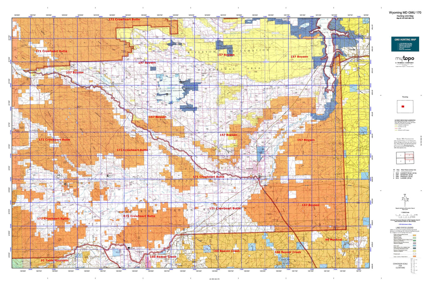
Hunting unit map of Wyoming Game Management Unit MD-170 with topographic lines and unit boundaries. This topo map features UTM / MGRS and Latitude/Longitude grids, plus public land ownership. It comes folded on waterproof paper. Be fully prepared for your hunt with a MyTopo GMU map!.
This map contains the following named places: 82510,82514,82515,82516,Albright Draw,Alkali Creek,Alkali Draw,Alkali Lake,Aragon Cemetery,Aragon Ditch,Arapahoe,Arapahoe Catholic Cemetery,Arapahoe Cemetery,Arapahoe Census Designated Place,Argo Butte,Beaver Creek,Berlin Draw,Big Corral Ditch,Big Ridge,Bighorn Butte,Bighorn Draw,Bighorn Flat,Bighorn Ridge,Blackburn Ditch,Blue Trail,Botts Creek,Boulder Flats,Boulder Flats Census Designated Place,Brown Draw,Carter Draw,Cedar Butte,Chavez Cemetery,Childs Spring Drain,City of Riverton,Collins Cemetery,Concetta Palicichio Mine,Coolidge Canal,Coolidge Ditch,Coolidge Turnout,Cottonwood Creek,Countryman Basin,Crooked Creek,Crusher Number 1-35 Mine,Dead Horse Slough,Delfelder,Delfelder Hall,Deshaw Ditch,Diversion Dam,Diversion Dam Park,Double Ditch,Double Dives,Doughty Draw,Dry Creek,Edmo Buttes,Enos Basin,Ethete,Ethete Census Designated Place,Ethete Number One Mine,Ethete Number Two Mine,Farmers Siding,Fivemile 52 Drain,Fivemile Lateral,Fivemile Main Lateral,Fort Washakie,Fort Washakie Census Designated Place,Fort Washakie Hot Spring Mine,Fort Washakie Underground Reservoir,Fremont County,Fremont Jade Quarry,Friday Cemetery,Gibbons Draw,Grave of N B Kinnear,Gustin Number 2 Reservoir,Hansen Drain,Hansen Drain Extension,Harris Bridge,Haymaker Creek,Hudson,Hudson Draw,Hurtado Cemetery,Hurtado Ditch,Ice Slough,Johnstown,Johnstown Census Designated Place,Johnstown Ditch,Johnstown Draw,Johnstown Valley,Juniper Butte,Kinnear,Kinnear Mine,Kinnear Valley,Kirby Draw,Laird,Lamoreaux Draw,Lateral P-27.0- A,Lateral P-27.0- B,Lateral P-27.0- C,Lateral P-27.0- D,Lateral P-28.2,Lateral P-31.7,Lateral P-31.7- B,Lateral P-32.8,Lateral P-34.0,Lateral P-34.9,Le clair Canal,Le Clair Cemetery,Le clair Diversion Dam,Le Clair Drain,Lefthand Ditch,Little Norkok Creek,Little Popo Agie River,Little Wind River,Lost Wells Butte,Lost Wells Lateral,Lyons Valley,Madden Draw,Martin Ponds,McCaskey Drain,Mead Mine,Mexican Flat,Middle Fork Sage Creek,Midvale,Midvale Irrigation Pit,Milford,Mill Creek,Mill Creek Drain,Mission Ditch,Missouri Valley,Mitchell Draw,Morton,Mountain View Cemetery,Mule Butte,Neble,Neble Hill,Norkok Butte,Norkok Creek,Norkok Meadows,Norkok Meadows Creek,North Fork Canyon Number One Mine,North Fork Canyon Number Two Mine,North Fork Ditch Number 1,North Fork Ditch Number 2,North Fork Ditch Number 5,North Fork Diversion Canal,North Fork Little Wind River,North Fork Sage Creek,Ocean Drain,Ocean Lake,Odd Fellows Cemetery,Paradise Valley,Paradise Valley Community House,Pavillion,Pavillion Butte,Pavillion Drain,Pilot Butte,Pilot Butte Dam Number 1,Pilot Butte Oil Field,Pilot Butte Power Plant,Pilot Butte Reservoir,Pilot Canal,Pilot Drain,Popo Agie River,Preacher Draw,Prison Farm Draw,Ray Canal,Ray Dam,Ray Lake,Ray Reservoir,Riverton,Riverton Acid Plant Mine,Riverton Airport Pit,Riverton Country Club,Riverton Draw,Riverton Memorial Hospital Heliport,Riverton Number 2 Canal,Riverton Pit,Riverton Regional Airport,Riverton Valley,Riverview Valley,Rush Slough,S G Drain,Sacajawea Cemetery,Sage - Red Man Cemetery,Sage Creek,Sage Creek Anticline Mine,Sage Creek Number One Mine,Sage Creek Number Three Mine,Sage Creek Number Two Mine,Saint Michael Mission Cemetery,Saint Stephens,Sand Butte,Sand Butte Lateral,Sand Draw,Sand Gulch,Sand Gulch Lateral,Sand Hills,Sandstone Butte,Sevenmile Hill,Shakespare Cemetery,Sharp Nose Drain,Sharp Nose Draw,Shriner Draw,Sioux Ditch,South Fork Little Wind River,South Fork Sage Creek,Spencer Draw,Spring Creek,Stagner Ridge,Sub-Agency Ditch,Sunnyside Drain,Surrell Creek,Town of Hudson,Town of Pavillion,Trout Creek,Upper Milford School,Valley View Store,Warren Drain,White Horse Draw,Winchester Butte,Winchester Ditch,Winchester Draw,Wind River,Wind River Diversion Dam,Wind River Division,Wind River Indian Reservation Number One Mine,Wind River Mountain Front Number One Mine,Wind River Mountain Front Number Six Mine,Wind River Mountain Front Number Three Mine,Winkleman Dome,Winkleman Dome Oil Field,Wise Ditch,Wyoming Central Canal,Wyoming Central Mine,Wyoming Penitentiary Farm,Wypo Sand and Gravel Pit