
MyTopo
Wyoming Mule Deer GMU 47 Map
Couldn't load pickup availability
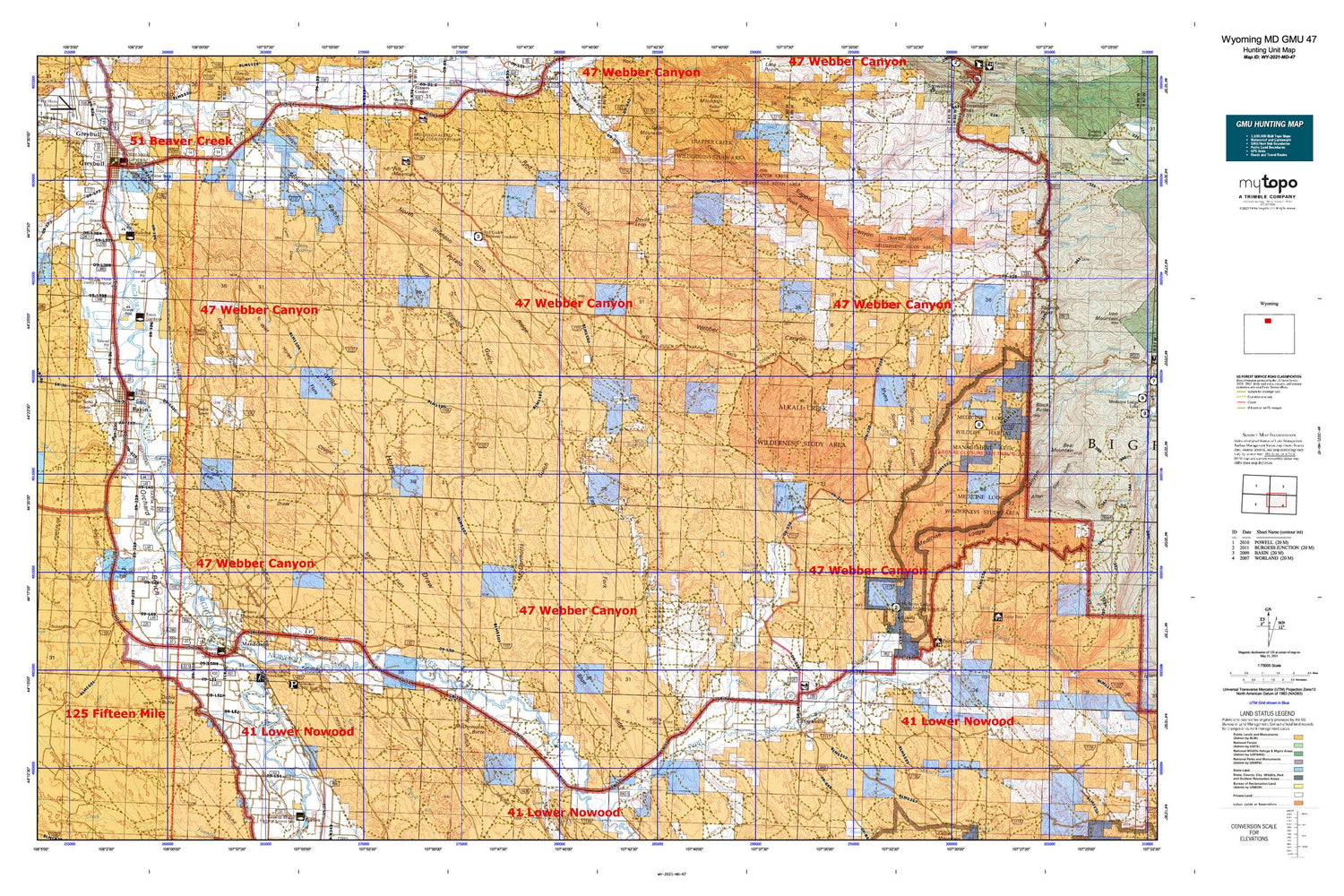
Hunting unit map of Wyoming Game Management Unit MD-47 with topographic lines and unit boundaries. This topo map features UTM / MGRS and Latitude/Longitude grids, plus public land ownership. It comes folded on waterproof paper. Be fully prepared for your hunt with a MyTopo GMU map!.
This map contains the following named places: 82428,Ainsworth Pumping Station,Alamo Creek,Alkali Creek,Alkali Flats,Alkali Spring,Anita Ditch,Anomaly Number Four Mine,Antelope Creek,Atwood's Family Ambulance,Avent Ditch,Basin,Basin Flats,Basin Pioneer Cemetery,Basin Police Department,Basin Post Office,Basin Volunteer Fire Department,Battle Creek,Beaver Hill Mines,Big Bear Ditch,Big Horn County Sheriff's Office,Big Horn Fire District 3,Big Horn Redi-Mix Incorporated Mine,Bighorn National Forest Medicine Wheel - Paintrock Ranger District Fire Engine Crew,Blue Ridge,Blue Ridge Detention Dam,Blue Ridge Reservoir,Bonnie Bluejacket Nursing Home,Buck Draw,Burgess Claim,Bush Butte,Bush Creek,C C Reservoir,Carey Draw,Carey Reservoir,Cloud Peak Middle School,Coyote Gulch,Dead Horse Gulch,Deadman Gulch,Deer Draw Reservoir,Devils Leap,Dobie Butte,Dobie Creek,Doyle Reservoir,Dresser Bentonite Clay Mine,Dry Bush Creek,Dry Medicine Lodge Canyon,Dry Medicine Lodge Creek,Durphy Gulch,East Basin Draw,East Fork McDermotts Gulch,Elk Creek,Enlargement of the Walters Dam,Flagstaff Mine,Flitner Reservoir,Fox Mountain,Garnett Lake,Go-Ahead Ditch,Greer Ranch,Greybull,Greybull Elementary School,Greybull Emergency Medical Services,Greybull High School,Greybull Middle School,Greybull Mine,Greybull Police Department,Greybull Post Office,Greybull River,Greybull Volunteer Fire Department,Harmony Ditch,Highland Ditch,Hyatt Ranch,Hyattville,Hyattville Cemetery,Hyattville Census Designated Place,Hyattville Post Office,Hyattville School,Jack Creek,Jones Draw,Jones Reservoir,KZMQ-AM (Greybull),L. E. Collinwood Bentonite Mine,Lamb Oil Field,Laura Irwin Elementary School,Luman Creek,Manderson,Manderson Cemetery,Manderson Elementary School,Manderson Oil Field,Manderson Post Office,McDermotts Butte,McDermotts Gulch,Medicine Lodge Canyon,Medicine Lodge Creek,Medicine Wheel Ranger District,Military Creek,Military Ditch,Mount View Cemetery,Mudstone Claims Mine,Myers Spring,Myers Spring Draw,North Sheldon Gulch,Nowood River,Orchard Bench,Paintrock Area Mine,Pearce Well,Perkins Dam,Perkins Reservoir,Potato Draw,Potato Ridge,Potato Ridge Mine,Prairie Dog Spring,Pritchards Grove Picnic Area,Red Basin,Reeves Ranch Mine,Riverside Middle - High School,Rogers and Gapin Mine,Sand Creek,Sanguine Claim Mine,Sanguine Number Twelve Mine,Schoolhouse Gulch,Schroll Draw,Shafer Ditch,Sheep Springs,Sheep Springs Canyon,Shell Canal,Shell Creek Prospect Mine,Shirran Pit,Smith Family Cemetery,South Big Horn County Critical Access Hospital,South Big Horn Division,South Fork Elk Creek,South Paint Rock Reservoir,South Sheldon Gulch,Split Ear Spring,Spring Creek,Springs Creek,Taylor Ranch,The Arch,Thomas Coulee Reservoir,Tilard Canal,Tin Can Alley,Torchlight Dome Oil Field,Town of Basin,Town of Greybull,Town of Manderson,Trapper Canyon,Valley Ranch Mine,Walters Dam,Walters Reservoir,Walters Supply Ditch,Webber Canyon,Weintz Draw,White Sulphur Spring,Wild Horse Draw,Wild Horse Flats,Wyoming Retirement Center


