MyTopo
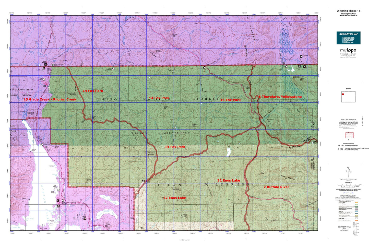
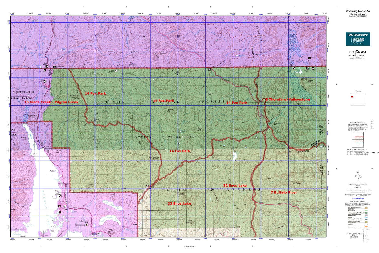
Wyoming Moose 14 Map
Couldn't load pickup availability
Hunting unit map of Wyoming Game Management Unit MOOSE-14 with topographic lines and unit boundaries. This topo map features UTM / MGRS and Latitude/Longitude grids, plus public land ownership. It comes folded on waterproof paper. Be fully prepared for your hunt with a MyTopo GMU map!.
This map contains the following named places: 83013,Arizona Creek,Arizona Creek Trail,Arizona Island,Arizona Lake,Atlantic Pacific Creek Trail,Bailey Creek,Bailey Meadows,Berry Creek,Big Game Ridge,Big Game Ridge Cutoff Trail,Bobcat Ridge,Brown Meadows,Burnt Creek,Camp Creek,Clear Creek Lake,Colter Bay,Colter Bay Post Office,Colter Bay Village,Colter Canyon,Coulter Creek,Coulter Creek Tail,Coulter Creek Trail,Coulter-Wolverine Cutoff Trail,Cow Island,Crawfish Creek,Crawfish Creek Hot Springs,Crooked Creek,Cygnet Pond,Daniels Creek,Dime Creek,Divide Lake,Divide Trail,East Fork Pilgrim Creek,East Whetstone Creek,Emerald Lake,Emma Matilda Lake,Emma Matilda Lake Trail,Enos Creek,Enos Creek Cutoff Trail,Enos Lake,Enos Lake Patrol Cabin,Enos Lake Trail,Ermine Creek,Evermann Creek,Flagg Ranch,Fonda Point,Forest Creek,Forest Lake,Fox Creek,Fox Creek Patrol Cabin,Fox Park Flat,Fox Park Patrol Cabin,Glade Creek,Grand Teton National Park / Colter Bay Fire Department,Grand View Point,Gravel Creek,Gravel Creek Patrol Cabin,Gravel Lake,Gravel Mountain,Gravel Peak,Gravel Ridge,Harebell Creek,Harebell Creek Patrol Cabin,Harebell Trail,Harem Hill,Heron Pond,Huckelberry Hot Spring,Huckleberry Hot Springs,Huckleberry Mountain,Huckleberry Ridge,Indian Island,Jackson Lake,Jackson Lake Hot Springs,John D Rockefeller Jr Memorial Parkway,Joy Creek,Joy Peak,Joy Peak Lake,Leeks Lodge,Lewis Canyon,Lewis River,Little Mackinaw Bay,Lizard Creek,Lizard Creek Campground,Mariposa Lake,Middle Pilgrim Trail,Mink Creek,Mink Creek Cutoff Trail,Moose Creek,Moose Falls,Moose Island,Moss Lake,Moss Lake Trail,Mount Hancock,Mount Reid,Nickel Creek,North Buffalo Fork Springs,North Buffalo Trail,North Fork Meadows,North Fork Rodent Creek,North Two Ocean Creek,Pacific Creek Trailhead,Parting of the Waters Natural Landmark,Pelican Bay,Phelps Pass,Pilgrim Creek Trail,Pilgrim Mountain,Pinyon Peak,Plateau Creek,Plateau Falls,Polecat Creek,Quarter Creek,Red Creek,Rodent Creek,Rodent Creek Trail,Sargents Bay,Sheffield Creek,Sheffield Creek Trail,Sheffield Creek Trailhead,Snake Hot Springs,Snake River Lookout Station,Snake River Ranger Station,Snake River Recreation Site,Snake River Trail,Snowslide Creek,Soda Fork,Soda Fork Meadows,Soda Springs,South Boundary Trail,South Entrance,South Entrance Hot Springs,Spirea Creek,Steamboat Mountain,Swan Lake,Tanager Lake,Teton County,Toppan Lake,Trail Creek,Trail Creek Trail,Two Ocean Lake,Two Ocean Lake Trail,Two Ocean Pass,Waterfalls Canyon,Watkins Ditch,Weasel Creek,Webb Canyon,West Cutoff Trail,West Pilgrim Trail,West Whetstone Creek,Whetstone Creek,Whetstone Creek Trail,Whetstone Mountain,Wilcox Point,Wildcat Peak,Wildcat Ridge,Wilderness Ranch,Wolverine Creek