MyTopo
Wyoming Moose 16 Map
Couldn't load pickup availability
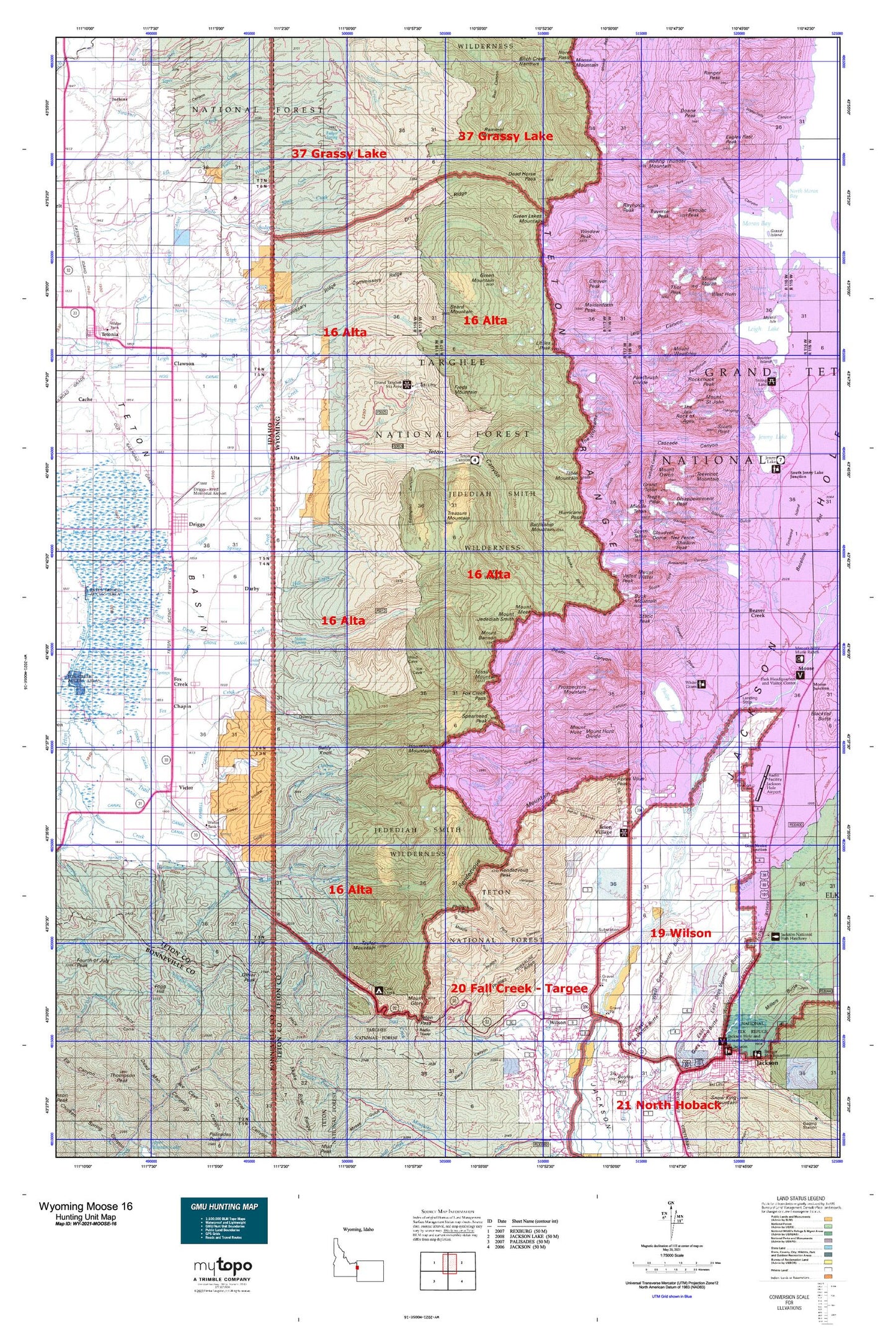
Hunting unit map of Wyoming Game Management Unit MOOSE-16 with topographic lines and unit boundaries. This topo map features UTM / MGRS and Latitude/Longitude grids, plus public land ownership. It comes folded on waterproof paper. Be fully prepared for your hunt with a MyTopo GMU map!.
This map contains the following named places: Alaska Basin Trail,Albright Peak,Allen Creek,Alta,Alta Division,Amphitheater Lake,Amphitheater Lake Trail,Anchor Ranch,Andy Stone Creek,Andy Stone Trail,Apres Vous Peak,Arrowhead Pool,Aspen Ranch,Baldy Knoll,Basin Lakes,Battleship Mountain,Beard Mountain,Beaver Creek,Beaver Creek Trail,Bivouac Peak,Blind Creek,Bradley Lake,Bradley Lake Trail,Buck Mountain,Burbank Creek,Bustle Creek,Camp Lake,Cascade Canyon Trail,Cascade Creek,Cascade Ranger Station,Chapin,Cirque Lake,City of Driggs,City of Victor,Clawson,Cleaver Peak,Cloudveil Dome,Coal Creek,Coal Creek Campground,Coal Creek Meadows,Coyote Lake,Crater Lake,Crows Nest,Darby,Darby Girls Camp,Deadwood Creek,DeCoster Trail,Delta Lake,Devils Stairs,Disappointment Peak,Doane Peak,Driggs,Dry Creek,Dry Ridge Mountain,Dudley Lake,Eagles Rest Peak,East Horn,East Prong,Elbow Fork,Elk Exhibition Pasture,Fish Creek,Fogg Hill,Forget-me-not Lakes,Fossil Mountain,Fox Creek,Freds Mountain,Game Creek,Game Creek Trail,Glacier Creek,Grand Targhee Resort,Grand Teton,Granite Basin Lakes,Granite Canyon Trail,Granite Creek,Green Lake,Green Lakes Mountain,Green Mountain,Green Mountain Trail,Grizzly Bear Lake,Gros Ventre River,Grouse Creek,Hidden Falls Horse Trail,Hill Creek,Holly Lake,Housetop Mountain,Hungry Creek,Hunts Corral,Icefloe Lake,Indian Lake,J Y Ranch,Jackson Hole Country Club,Jackson Hole Ski Area,Jackson National Fish Hatchery,Jedediah Smith Wilderness,Johns Creek,Juniper Creek,Kiln Creek,Kit Lake,Lake Creek,Lake of the Crags,Lake Solitude,Lake Solitude Trail,Lake Taminah,Laurel Lake,Lee Guard Station,Leigh Creek,Little Dry Creek,Littles Peak,Maidenform Peak,Mail Cabin Creek,Marion Lake,Mesquite Creek,Mica Lake,Middle Fork Cut Off Trail,Middle Fork Granite Creek,Middle Leigh Creek,Middle Teton,Mike Harris Camnpground,Mike Harris Creek,Miles Creek,Mill Creek,Mink Lake,Moose Creek,Moose Creek Ranch,Moose Lake,Moose Pond,Moose Wilson Road,Moran Creek,Moran Lake,Mount Bannon,Mount Glory,Mount Hunt,Mount Jedediah Smith,Mount Meek,Mount Moran,Mount Owen,Mount Saint John,Mount Wister,Mount Woodring,Mud Lake,Nez Perce,North Badger Creek,North Fork Darby Creek,North Fork Game Creek,North Fork Granite Creek,North Fork Moran Creek,North Fork Teton Creek,North Fork Trail Creek,North Leigh Creek,North Leigh Creek Trail,North Moran Creek,Oliver Peak,Open Canyon Trail,Ortenburger Lake,Paintbrush Canyon Trail,Paintbrush Divide Trail,Pass Lake,Phelps Lake,Phillips Canyon Trail,Prospectors Mountain,R Lazy S Ranch,Rammell Mountain,Ramshead Lake,Ramshield Lake,Ranger Peak,Rapid Creek,Raynolds Peak,Rendezvous Mountain,Rendezvous Mountain Trail,Rendezvous Peak,Rimrock Lake,Roaring Creek,Rock Creek,Rockchuck Peak,Rolling Thunder Mountain,Shadow Peak,Ski Lake,Slocum Creek,Snowdrift Lake,Sorensen Creek,South Badger Creek,South Fork,South Fork Darby Creek,South Fork Game Creek,South Fork Granite Creek,South Fork Hill Creek,South Fork Moran Creek,South Fork Teton Creek,South Leigh Creek Trail,South Leigh Lakes,South Teton,Spearhead Peak,Spring Creek,Spud Drive-In,Static Peak,Steep Creek,String Lake Trail,Sunset Lake,Surprise Lake,Table Mountain,Taggart Lake,Taggart Lake Trail,Talus Lake,Taylor Mountain,Teewinot Mountain,Terrace Creek,Teton Campground,Teton Village,The Jaw,The String,The Wedge,Thor Peak,Timberline Lake,Tin Cup Creek,Trail Creek Campground,Trail Creek Ranch,Traverse Peak,Treasure Lake,Treasure Mountain,Treasure Mountain Camp,Valley Trail,Veiled Peak,Victor,Victor Division,Warm Springs Ranch,Weir,West Burbank Creek,West Gros Ventre Butte,West Horn,White Grass Ranch,White Grass Ranger Station,Wildcat Creek,Wilson,Window Peak,Yellow Creek