
MyTopo
Wyoming Moose 24 Map
Couldn't load pickup availability
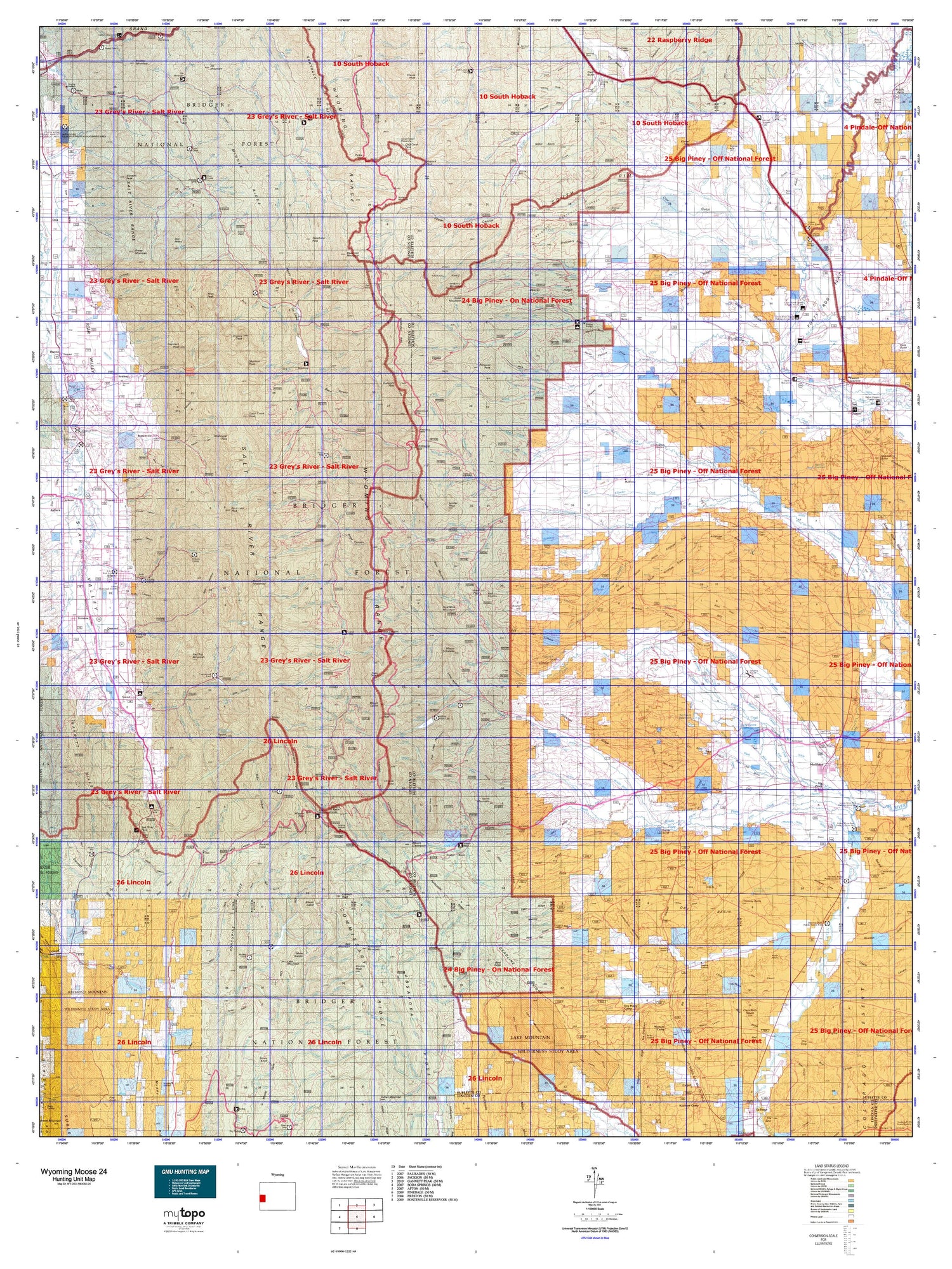
Hunting unit map of Wyoming Game Management Unit MOOSE-24 with topographic lines and unit boundaries. This topo map features UTM / MGRS and Latitude/Longitude grids, plus public land ownership. It comes folded on waterproof paper. Be fully prepared for your hunt with a MyTopo GMU map!.
This map contains the following named places: Afton,Afton Division,Afton Rest Area,Alice Creek,Anderson Creek,Apperson Creek,Aspen Creek,Aspen Ridge Pit Reservoir,Astle Creek,Bailey Cone,Bailey Lake,Bald Hornet Creek,Bald Knoll,Bald Mountain,Bare Creek,Bare Mountain,Bear Creek,Beaver Creek,Beaver Dam Creek,Bedford,Beecher Creek,Bench Corral,Big Fall Creek,Big Mesa,Big Piney,Big Piney Division,Bird Nipple,Black Canyon Creek,Blind Bull Lake,Box Y Ranch,Bradley Mountain,Bridger National Forest,Bronx,Buckskin Knoll,Budd Reservoir,Bull Mountain,Cabin Creek,Cabin Creek Peak,Camp Creek,Chimney Butte,Chimney Butte Reservoir,Clark Butte,Clause Creek,Clause Peak,Coal Creek,Coal Mine Mountain,Coantag Creek,Corral Creek Guard Station,Corral Creek Lake,Cottonwood Lake,Cottonwood Lake Campground,Coyote Reservoir,Cretaceous Mountain,Crooked Creek,Crow Creek Lakes,Crystal Lake,Crystal Lake Recreation Site,Culbertson Creek,D B Budd Butte,Daniel,Daniel Junction,Dead Dog Creek,Dead Indian Dome,Dead Shot Ranch,Deadman Mountain,Deer Creek,Deer Creek Guard Station,Deer Hill,Devils Hole Lakes,Dry Creek Lake,Dry Island,Dry Piney Camp,Dry Piney Creek,Electric Peak,Elk Mountain,Fawn Creek,Fear Ditch Reservoir,Fish Creek Mountain,Flat Top Reservoir,Fleming Slough,Fontenelle Lakes,Fontennelle Mountain,Forest Park Campground,Forest Park Elk Wintering Area,Forked Creek,Forks Campground,Forty Rod Creek,Forty Rod Reservoir,Franz Reservoir,Graham Peak,Greys River District Ranger Office,Grover,Grover Park,Halfway,Haystack Peak,Hoback Peak,Hobble Creek Recreation Site,Horn Reservoir,Horse Mountain,Hot Foot Creek,Jewett Pinnacle,Jewett Red Flat Reservoir,Kismet Peak,KOA Campground,La Barge Creek,LaBarge Guard Station,Lake Alice,Lake Barstow,Lake Creek,Lake Mountain,Lander Peak,Lincoln County Fair Grounds,Little Fall Creek,Little Mesa,Long Island,Lookout Mountain,Lost Creek,Lost Horse Creek,Lost Lake,Lynx Creek,Lynx Creek Campground,Man Peak,Marbleton,McCain Guard Station,McDougal Creek,Meadow Canyon Creek,Meadow Creek Guard Station,Meadows Forest Service Facility,Merna,Merna Butte,Middle Piney Lake,Middle Piney Lake Campground,Middle Piney Reservoir,Middle Piney Summer Home Area,Miner Creek,Mistum Creek,Moose Flat Campground,Mount Coffin,Mount Darby,Mount Fitzpatrick,Mount Isabel,Mount McDougal,Mount Schidler,Mount Thompson,Mount Wagner,Mountain Home Ranch,Mud Creek,Mud Lake,Murphy Creek Campground,Murphy Lakes,North Beaver Creek,North Channel Middle Piney Creek,North Fork Dry Piney Creek,North Mountain,North Piney Lake,Old Fort Bonneville Site,Onion Creek,Osmond,Packer Creek,Peroidic Spring Recreation Site,Pine Grove Reservoir,Pixley Creek,Porcupine Creek,Prater Mountain,Prospect Peak,Rands Butte,Red Castles,Red Hill,Red Top Mountain,Roaring Fork Lakes,Robinson Butte,Rock Lake,Rock Lake Peak,Rough Creek,Round Hill,Ryegrass Junction,Ryegrass Reservoir,Sacajawea Campground,Salt River Pass Recreation Site,Sand Hill,Scaler Guard Station,Shannon Point,Sheep Creek,Sherman Guard Station,Sherman Peak,Signal Hill,Sixty-Seven Butte,Sixty-Seven Reservoir,Slide Lake,Smiths Fork Guard Station,Smoot,Snyder Basin Guard Station,Snyders Camp,Soda Lake,South Apperson Creek,South Doe Creek,South Fork Hams Fork,South Fork Stoner Creek,South La Barge Creek,South Three Forks Lakes,Sphaeralcea Reservoir,Spring Creek,Spring Lake,Star Hill,Star Valley Ranch,Stewart Peak,Straight Creek,Stump Lake,Swift Creek Campground,Swift Creek Lake,Tarters Island,The Frog,Tie-Hack Cabins,Town of Afton,Town of Big Piney,Town of Marbleton,Travelute Reservoir,Travis Lake,Triple Peak,Tripod Hill,Turnerville,Turnerville Community,Twin Creek Lakes,Virginia Peak,Visser Peak,Wagner Lake,Waterdog Lake,Way Creek,Webster Hill,West Meadow Canyon Creek,Western Camp,Wickiup Knoll,Willow Creek,Wyoming Game and Fish Administrative Site,Wyoming Peak


