MyTopo
Wyoming Moose 32 Map
Couldn't load pickup availability
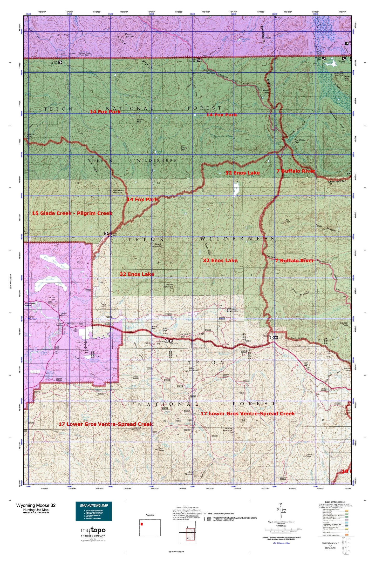
Hunting unit map of Wyoming Game Management Unit MOOSE-32 with topographic lines and unit boundaries. This topo map features UTM / MGRS and Latitude/Longitude grids, plus public land ownership. It comes folded on waterproof paper. Be fully prepared for your hunt with a MyTopo GMU map!.
This map contains the following named places: 83013,Angle Mountain,Angles Trailhead,Atlantic Pacific Creek Trail,Baldy Mountain,Bear Cub Pass,Big Game Ridge,Big Game Ridge Cutoff Trail,Black Rock Meadows Mine,Blackrock Creek,Blackrock Meadows,Blackrock Ranger District Office,Blackrock Ranger Station,Bobcat Ridge,Box Creek,Box K Ranch,Boy Creek Trailhead,Bridger - Teton National Forest Blackrock - Buffalo Ranger District Fire Engine Crew,Brush Creek,Buffalo Fork,Buffalo Fork Entrance Station,Buffalo Valley Ranch,Bull Creek,Burnt Creek,Burro Hill,Camp Creek,Clear Creek,Clear Creek Lake,Clear Creek Trail,Coal Creek,Coal Mine Draw,Coulter Creek,Coulter Creek Tail,Coulter Creek Trail,Coulter-Wolverine Cutoff Trail,Crooked Creek,Daniels Creek,Davis Hill,Divide Lake,Divide Trail,Dry Lake,East Whetstone Creek,Elk Ranch Reservoir,Emerald Lake,Emma Matilda Lake Trail,Enos Creek,Enos Creek Cutoff Trail,Enos Lake,Enos Lake Patrol Cabin,Enos Lake Trail,Ermine Creek,Evermann Creek,Eynon Draw,Flagstaff Creek,Fourmile Meadow,Fourmile Meadow Picnic Area,Fox Creek,Fox Creek Patrol Cabin,Fox Park Flat,Fox Park Patrol Cabin,Gravel Creek,Gravel Creek Patrol Cabin,Gravel Lake,Gravel Mountain,Gravel Peak,Gravel Ridge,Grizzly Creek,Grouse Creek,Grouse Mountain,Halfmoon Lake,Harebell Creek,Harebell Creek Patrol Cabin,Harebell Trail,Hatchet Campground,Heart Six Ranch,Jackson Hole Fire and Emergency Medical Services - Firehouse 4 Moran,Jay Creek,Johnson Mine,Joy Creek,Joy Peak,Joy Peak Lake,Lava Creek,Lava Creek Campground,Lava Creek Trail,Leidy Creek,Leidy Lake,Lily Lake,Mariposa Lake,Marys Lake,Mink Creek,Mink Creek Cutoff Trail,Moran,Moran Junction,Moran Post Office,Moran School,Moss Lake,Moss Lake Trail,Mount Hancock,Mount Leidy,Mount Randolph,Mud Lake,Nation Creek,North Buffalo Fork,North Buffalo Fork Springs,North Buffalo Trail,North Fork Meadows,North Fork Rodent Creek,North Fork Spread Creek,North Two Ocean Creek,Pacific Creek,Pacific Creek Trailhead,Parting of the Waters Natural Landmark,Phelps Pass,Pilgrim Creek Trail,Pinto Ranch,Pinyon Peak,Plateau Creek,Plateau Falls,Porter Dam,Porter Reservoir,Preacher Park,Rock Creek,Rodent Creek,Rosies Ridge,Sagebrush Flat,Senecio Creek,Skull Creek,Skull Creek Meadows,Snake River Trail,Snowslide Creek,Soda Fork,Soda Fork Meadows,Soda Springs,South Buffalo Fork,South Fork Spread Creek,South Two Ocean Creek,Split Rock Creek,Terrace Mountain,Teton Wilderness,Third Creek,Thorofare Creek,Three Rivers Ranch,Togwatee Overlook,Togwotee Lodge,Toppan Lake,Toppings Lakes,Tracy Lake,Tracy Lake Dam,Trail Creek,Trail Creek Trail,Turpin Meadow,Turpin Meadow Campground,Turpin Meadow Lodge,Turpin Meadow Trailhead,Two Ocean Lake,Two Ocean Lake Trail,Two Ocean Pass,Uhl Dam,Uhl Draw,Uhl Hill,Uhl Reservoir,Wallace Draw,Wallace Draw-Reservoir,Weasel Creek,West Cutoff Trail,West Whetstone Creek,Whetstone Creek,Whetstone Creek Trail,Whetstone Mountain,Wilderness Ranch,Wolverine Creek