
MyTopo
Wyoming Moose 8 Map
Couldn't load pickup availability
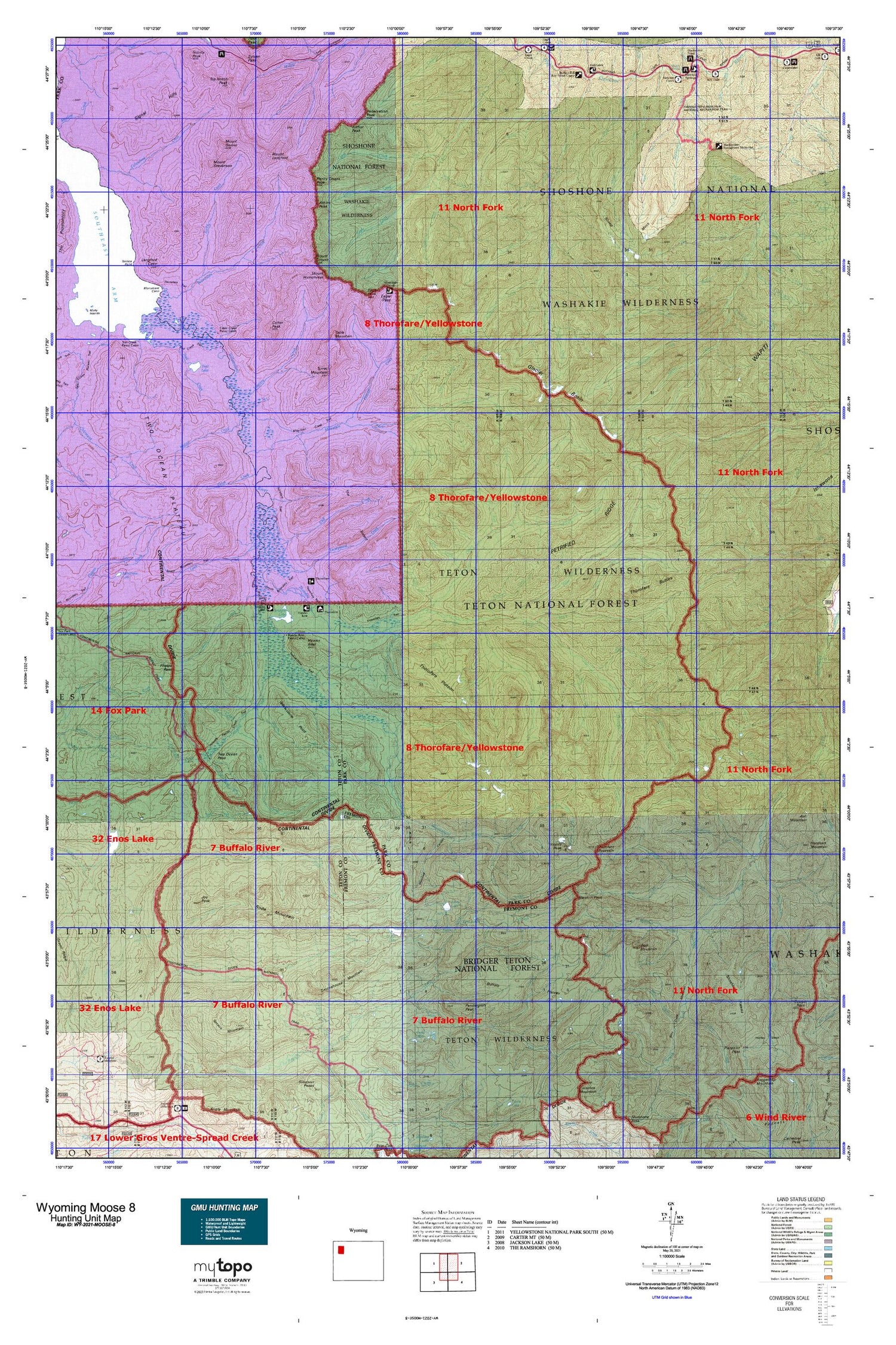
Hunting unit map of Wyoming Game Management Unit MOOSE-8 with topographic lines and unit boundaries. This topo map features UTM / MGRS and Latitude/Longitude grids, plus public land ownership. It comes folded on waterproof paper. Be fully prepared for your hunt with a MyTopo GMU map!.
This map contains the following named places: Angle Lakes,Arthur Peak,Atkins Peak,Atlantic Creek,Avalanche Creek,Badger Creek,Battlement Mountain,Beaverdam Creek,Bertha Lake,Big Springs,Blackwater Natural Bridge,Blackwater Trail,Bliss Creek,Bliss Creek Meadows,Bloom Creek,Blue Lakes,Borner Fork,Borron Creek,Bridger Lake,Brimstone Basin,Bruin Creek,Buffalo Plateau,Burned Timber Creek,Butte Creek,Butte Creek Trail,Cabin Creek,Cabin Creek Patrol Cabin,Camp Creek,Castle Creek,Chaos Mountain,Chimney Creek,Chimney Rock,Clark Creek,Clayton Mountain,Cliff Creek,Cloudburst Creek,Clouds Home Peak,Colter Peak,County Line Creek,Cowdell Waste Water Ditch,Coxcomb Mountain,Coyote Creek,Crater Lake,Crouch Creek,Crouch Prospect Mine,Daniels Creek,Deer Creek Pass,Dell Creek,Dike Creek,Double Mountain,Eagle Creek Meadows,Eagle Nest,Eagle Pass,Eagle Peak,East Fork Creek,Elizabeth Creek,Elk Creek,Escarpment Creek,Esmond Forks,Evermann Creek,Eyrie Creek,Falcon Creek,Falls Creek,Ferry Lake,Fire Memorial Trail,Firefighter Monument,Fishhawk Creek,Fishhawk Glacier,Fishhawk Meadows,Flora Lake,Fortress Mountain,Glacier Basin,Glacier Creek,Gobblers Knob,Goff Creek,Golden Lake,Gunbarrel Creek,Hawks Rest,Hawks Rest Patrol Cabin,Hidden Basin,Hidden Creek,Howell Creek,Howell Fork,Howell Mountain,Ishawooa Cone,Ishawooa Pass,Jay Creek,Joy Creek,Joy Peak,Joy Peak Lake,Kingfisher Peak,Kitty Creek,Kitty Creek Summer Homes,Lake Creek,Lake Fork Falls,Langford Cairn,Lost Creek,Lynx Creek,Mackinaw Lake,Marston Creek,Marston Pass,Marston Pass Trail,Mesa Creek,Monument Cairn,Mount Doane,Mount Humphreys,Mount Langford,Mount Schurz,Mount Stevenson,Mountain Creek,Mountain Creek Trail,Natural Bridge Trail,Nawlin Meadow Patrol Cabin,Neva Creek,Newton Creek,Newton Creek Campground,Newton Spring Picnic Ground,Norris Creek,North Buffalo Fork Springs,North Buffalo Trail,North Fork Butte Creek,North Fork Falls,North Fork Meadows,North Fork Yellowstone River,North Two Ocean Creek,Nowlin Meadow,Open Creek,Open Creek Trail,Overlook Mountain,Paradise Valley,Parting of the Waters Natural Landmark,Pass Creek,Pass Creek Trail,Pendergraft Meadow,Pendergraft Peak,Petrified Ridge,Phelps Pass,Phlox Creek,Pinnacle Mountain,Plenty Coups Peak,Post Point,Rainbow Lake,Rampart Creek,Rampart Pass,Reservation Peak,Robinson Creek,Rocky Creek,Ruth Creek,Scatter Creek,Seclusion Creek,Senecio Creek,Sheep Mesa,Shoshone Plateau,Siggins Fork,Signal Hills,Silvertip Creek,Smokehouse Mountain,Snowslide Creek,Soda Fork,Soda Fork Meadows,Soda Fork Trail,Soda Mountain,Soda Springs,South Fork Falls,South Fork Trail,South Fork Yellowstone River,South Two Ocean Creek,Spruce Meadow,Table Mountain,Terrace Mountain,Terrace Point,Teton Wilderness,The Trident,Third Creek,Thorofare Buttes,Thorofare Creek,Thorofare Mountain,Thorofare Plateau,Thorofare Ranger Station,Thorofare Trail,Thunder Mountain,Top Notch Peak,Toppan Lake,Trail Creek,Trail Creek Trail,Trail Lake,Trappers Creek,Tri-county Lake,Trident Plateau,Turner Fork,Turret Mountain,Two Ocean Pass,Two Ocean Plateau,Upper Nowlin Meadow,Valley Fork,Wall Mountain,West Fork Blackwater Creek,West Fork Younts Creek,Woodard Canyon,Woody Creek,Yellow Mountain,Yellowstone Point,Yellowstone Trail,Younts Creek,Younts Peak


