
MyTopo
Wyoming Whitetail Deer GMU 114 Map
Couldn't load pickup availability
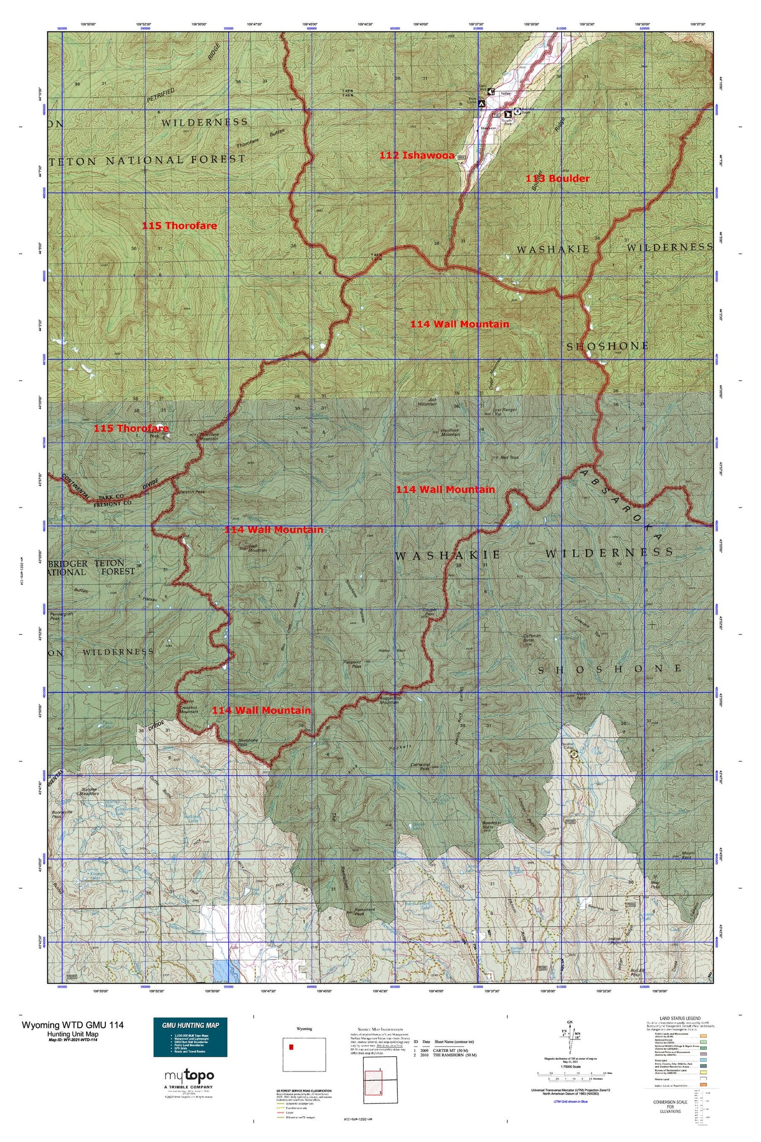
Hunting unit map of Wyoming Game Management Unit WTD-114 with topographic lines and unit boundaries. This topo map features UTM / MGRS and Latitude/Longitude grids, plus public land ownership. It comes folded on waterproof paper. Be fully prepared for your hunt with a MyTopo GMU map!.
This map contains the following named places: Ash Mountain,Aspen Creek,Basin Creek,Bear Pocket,Bliss Creek,Bliss Creek Meadows,Boday Creek,Boday Lake,Boedeker Butte,Bog Lakes,Borner Fork,Boulder Basin,Boulder Ridge,Bowles Pass,Bruin Creek,Buffalo Plateau,Bug Creek,Burwell Creek,Butte Creek,Butte Creek Trail,Cabin Creek,Caldwell Basin,Caldwell Creek,Canyon Creek,Carson Lake,Cartridge Creek,Castle Creek,Cathedral Peak,Clark Creek,Coffin Butte,Coffman Butte,Cougar Creek,Cougar Pass,Cougar Pass Trail,Crater Mountain,Crescent Creek,Crescent Mountain,Crescent Top,Crescent Trail,Deacon Lake,Deacon Meadows,Deer Creek,Deer Creek Campground,Deer Creek Pass,Dell Creek,Devils Graveyard,Double Cabin,Double Cabin Campground,Double Cabin Forest Service Station,Du Noir Butte,DuNoir Glacier,East Du Noir Trail,East Fork Creek,Elk Lake,Eloise Lake,Emerald Creek,Emerald Lake,Esmond Forks,Esmond Park,Fall Creek,Fire Creek,Five Pockets,Froms Lake,Frontier Creek,Frontier Creek Trail,Frozen Lake,Frozen Lake Creek,Gentian Creek,Gobblers Knob,Green Lake,Hardluck Mountain,Havely Rock Garden,Hawkeye,Hidden Basin,Hidden Pocket,Hunters Creek,Indian Point Trail,Kingfisher Peak,Kirwin Mine,Lake Pocket,Lincoln Point,Lost Ranger Top,Majo Ranch,Marston Creek,Marston Pass,Marston Pass Trail,McLaughlin Ditch,Needle Creek,Needle Mountain,North Fork Butte Creek,Norton Point,Pass Creek Trail,Perry N Boday Creek,Perry N Boday Lake,Petrified Forest,Pierpont Pass,Raggedtop Mountain,Ramshorn Basin,Ramshorn Trail,Red Tops,Robinson Creek,Rocking Chair Cow Camp,Saddle Creek,Sheep Creek,Sheep Lake,Sheepeater Creek,Shoshone National Forest,Shoshone Pass,Shoshone Plateau,Shoshone Trail,Silver Creek,Snow Lake,Snow Lake Creek,South Fork Burwell Creek,South Fork Ranger Station,South Fork Trail,South Pocket,Stinkingwater Mining Region,Stock Cabin,The Ramshorn,Thorofare Buttes,Thorofare Mountain,Twilight Creek,Twilight Creek Trail,Twilight Falls,Valley,Valley Fork,Wall Mountain,Washakie Wilderness,Watkins Lakes,West Fork Younts Creek,West Pocket,Wiggins Fork Trail,Wolf Creek,Woody Creek,Yellow Mountain,Younts Creek,Younts Peak


