
MyTopo
Wyoming Whitetail Deer GMU 125 Map
Couldn't load pickup availability
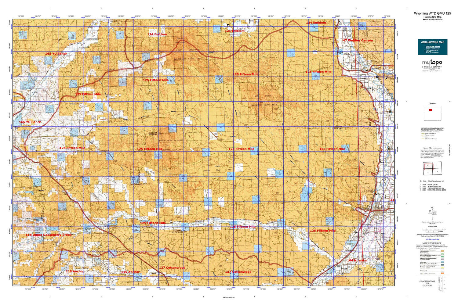
Hunting unit map of Wyoming Game Management Unit WTD-125 with topographic lines and unit boundaries. This topo map features UTM / MGRS and Latitude/Longitude grids, plus public land ownership. It comes folded on waterproof paper. Be fully prepared for your hunt with a MyTopo GMU map!.
This map contains the following named places: 82401,Asays Reservoir,Badger Creek,Badger Creek Basin,Badger Gulch,Baking Powder Springs,Basin Draw,Beaver Slide,Big Draw,Big Von Detention Dam,Big Von Reservoir,Blackburn Gulch,Blake-Denton Number 1 Dam,Blake-Denton Number 1 Reservoir,Blake-Denton Number 2 Dam,Blake-Denton Number 2 Reservoir,Blue Mesa,Blue Ridge,Bobcat Draw,Brewer Pit,Brown Pit Mine,Buck Buttes,Buffalo Creek,Bull Knoll,Butler Draw,Colter Draw,Corral Creek,Cottonwood Creek,Crooked Creek,Crooked Creek Detention Dam,Crooked Creek Reservoir,Dead Indian Hill,Dickie Number Two Mine,Dickie Ranch,Dickie Shearing Sheds,Dickies Number One Mine,Dobson Pond,Dry Cottonwood Creek,Dutch Nick Flat,East Ridge,Enos Creek,Enright Reservoir,Eoawrra Reservoir,Fenton Pass,Gillies Draw,Grass Creek,Grass Creek Basin,Grass Creek Basin Mine,Grass Creek Deposits Number One Mine,Grass Creek Mine,Green Cabin,Hewitt Place,Hillberry Dam,Hillberry Reservoir,Hillberry Rim,Holder Ditch,Hole in the Ground,Holland Ditch,Holly and Niccolls Ditch,Horseshoe Bedground,Hunt Reservoir,Jake Seller Draw,Joe Miller Cabin,John Miller Ranch,Johnson Cabin,Keg Spring,Kemick Cabin,Kennison Cabin,Left Hand Creek,Little Buffalo Basin,Little Buffalo Creek,Little John Ranch,Mayfield Number One Mine,Mayfields Ranch,McDonald Cabins,McGee Reservoir,Middle Creek,Middle Fork Fifteenmile Creek,Middle Fork Tenmile Creek,Moon Dam,Moon Reservoir,Mueller Cabin,Murdoch Cabin,Murphy Ditch,Murphy Draw,Neiber Ghost Town Cemetery,Neves Reservoir,Nohr Cabin,North Fork Fifteenmile Creek,North Fork Little Gooseberry Creek,Paradise Alley,Parker Spring Gulch,Parker Springs,Perkins Ditch,Peterson Ditch,Pine Tree Extension Ditch,Quartz Ditch,Quartz Gulch,Red Butte,Red Hill,Red Ridge,Red Spires Detention Dam,Red Spires Reservoir,Renner Draw,Reservoir Creek,Rimrock Basin,Rock Waterhole Creek,Rock Waterhole Detention Dam,Rock Waterhole Reservoir,Rosetta Detention Dam,Rosette Geyser,Sales Place,Sand Butte Detention Dam,Sand Butte Reservoir,Sand Draw,Sand Spring,Sand Spring Draw,Sawtooth,School Section Reservoir,Schuster Draw,Schuster Flats,Sheets Mountain,Shryack School,Sleeper Pit,Sleeper's Ranch,Snoopy Reservoir,Snort Geyser,South Fork Elk Creek,South Fork Fifteenmile Creek,South Fork Left Hand Creek,Squaw Teats,Star Ditch,Steele Ditch,Steele School,Stone Cabin,Sucker Dam,Sun Ditch,Tatman Mountain,Timber Creek,Wagon Hound Bedground,Webster Cabin,Whistle Berry Hill,Wide Draw Detention Dam,Wide Draw Reservoir,Wild Horse Corral,Wild Horse Heaven,Wilson Reservoir,Wilson Spring,Wortham Dam,Wortham Reservoir,Wortham School,Y U Ranch,Yu Ranch Airport


