
MyTopo
Wyoming Whitetail Deer GMU 127 Map
Couldn't load pickup availability
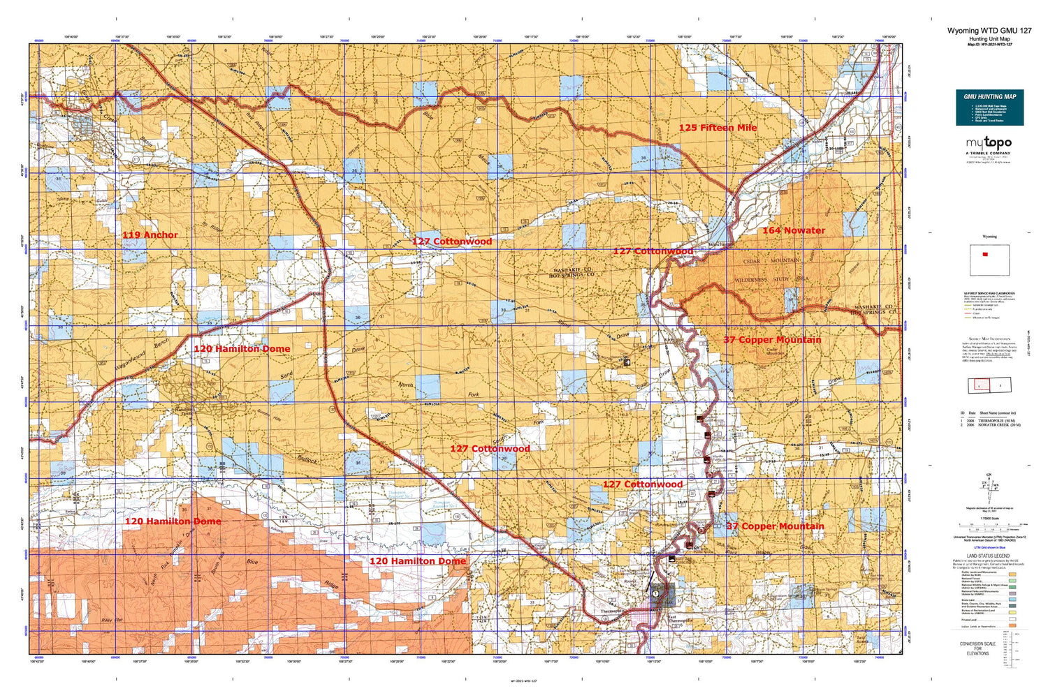
Hunting unit map of Wyoming Game Management Unit WTD-127 with topographic lines and unit boundaries. This topo map features UTM / MGRS and Latitude/Longitude grids, plus public land ownership. It comes folded on waterproof paper. Be fully prepared for your hunt with a MyTopo GMU map!.
This map contains the following named places: 82430,82443,Alkali Draw,Andreen Pit,Arapahoe Ranch,Big Spring,Black Sulphur Spring,Black Willow Draw,Blue Hill Spring,Blue Mesa,Blue Ridge,Boghole Spring,Boulder Gulch,Brooks Ranch,Burnell Number Five Mine,Burnell Number Four Mine,Burnell Number Six Mine,Burnell Number Three Mine,Cedar Mountain,Cedar Ridge,Chimney Gulch,Coal Draw,Coalmine Draw,Cottonwood Creek,Cottonwood Creek Mine,Cottonwood Number One Mine,Cover Slough,Cowboy Mine,Crosby Cemetery,Crosby Mine,Dempsey Canal,Devils Punch Bowl,Down Gulch,Dry Cottonwood Creek,Dry Fork,Eagel Mine,Eagle Draw,Embar,Freeman Draw,Gebo,Gebo Cemetery,Gloin Reservoir,Grass Creek,Grass Creek Basin,Grass Creek Basin Mine,Grass Creek Deposits Number Two Mine,Gumbo Hills,Gwynns Ranch,Haines Ranch,Hamilton Dome,Harris Spring,Harvey Pit,Highline Mine,Hiline Mine,Hot Springs County,Hot Springs County Airport,Hot Springs County High School,Hot Springs County-Thermopolis Municipal Airport,Hot Springs State Park,Ilo Ridge,Keg Spring,Kemp Ranch,Kirby,Kirby Creek,Kirby Ditch,Knight Spring,Legend Rocks,Lester Draw,Little John Ranch,Little Prospect Creek,Love Spring,Lucerne,Lucerne Census Designated Place,Lucerne Mine,M and M Mine,McElwee Dam,McElwee Reservoir,Meeteetse Draw,Middle Fork Mud Creek,Milek Family Cemetery,Monument Hill,Monument Hill Cemetery,Mud Creek,North Fork Coal Draw,North Fork Little Gooseberry Creek,North Fork Mud Creek,North Fork Owl Creek,North Fork Pumpkin Draw,Owl Creek,Owl Creek Census Designated Place,Owl Creek Pit,Padlock Rim,Park Pit,Prospect Creek,Pumpkin Creek,Pumpkin Draw,Putney Mine,Rainbow Terraces,Rattlesnake Gulch,Red Creek,Red Lane,Red Lane Gulch,Red Ridge,Riley Flat,Round Top,Rush Dam,Rush Reservoir,Sand Draw,Scotch Plunge,Shafer Pit,Smoky Row Cemetery,South Fork Coal Draw,South Fork Mud Creek,South Fork Owl Creek,South Fork Pumpkin Draw,South Side Ditch,Spring Draw,Spring Gulch,T Hill,Teepee Fountain,The Maytag Spring,The Willows,Thermopolis Hot Springs,Thermopolis West Division,Thompson Number 1 Dam,Thompson Number 2 Dam,Thompson Reservoir Number One,Thompson Reservoir Number Two,Tie Down Flats,Town of Kirby,Wagonhound Bench,Wagonhound Creek,Wagonhound Spring,Wales Dam,Wales Ranch,Wales Reservoir,Walters Draw,West Warm Springs Oil Field,Winchester,Winchester Cemetery,Winchester Chatham Station


