
MyTopo
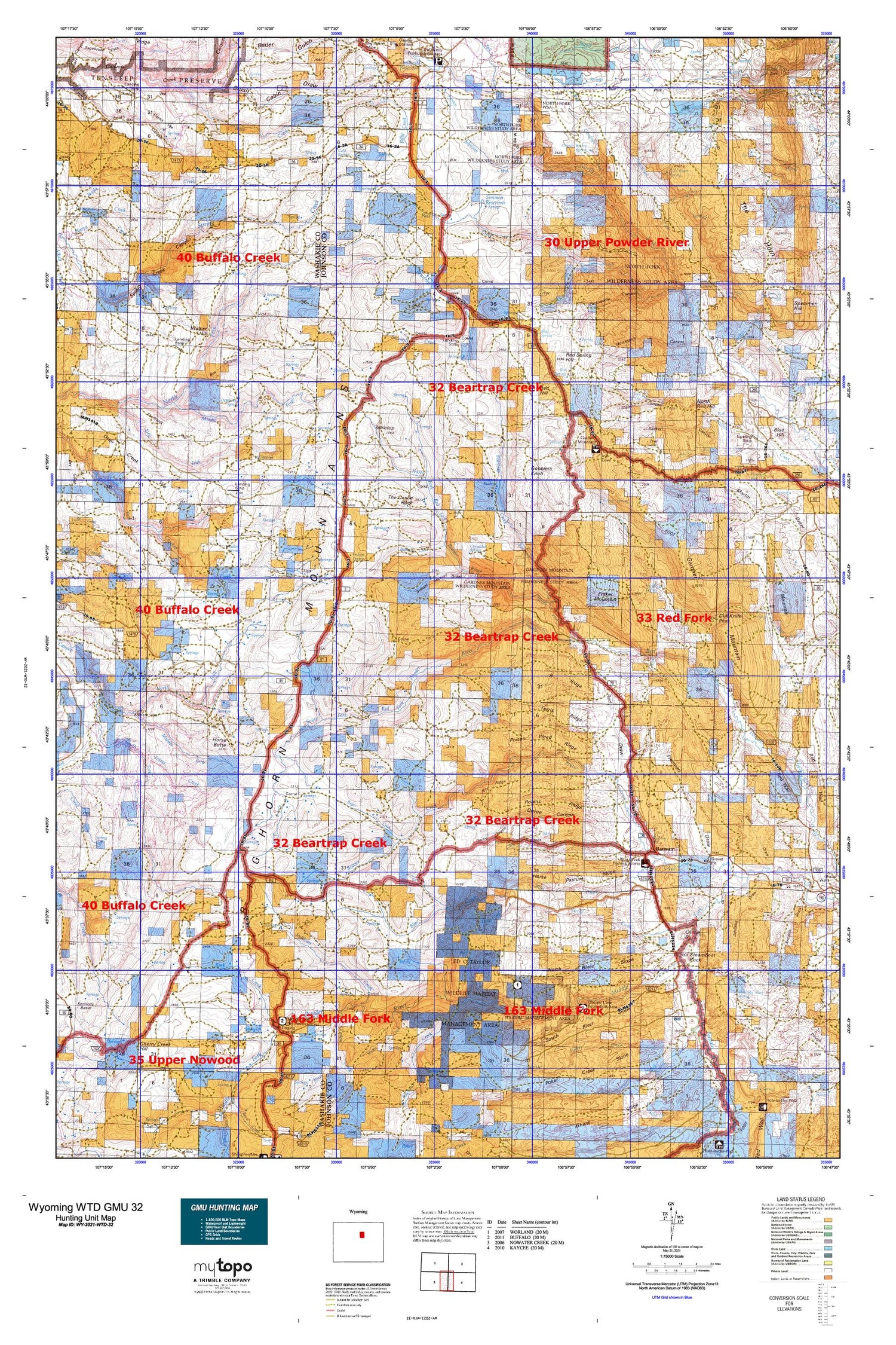
Wyoming Whitetail Deer GMU 32 Map
Couldn't load pickup availability
Hunting unit map of Wyoming Game Management Unit WTD-32 with topographic lines and unit boundaries. This topo map features UTM / MGRS and Latitude/Longitude grids, plus public land ownership. It comes folded on waterproof paper. Be fully prepared for your hunt with a MyTopo GMU map!.
This map contains the following named places: A Ridge,Andrews Corral,Arch Creek,Armstrong Cabin,Arndt Ranch,Bachaus Creek,Bachaus Pasture,Bader Gulch,Bald Knob,Baldwin Creek,Bar C Draw,Bar C Gap,Bar C Ranch,Barnum,Barnum Ditch,Barrett Ditch,Bayer Creek,Bear Spring,Beartrap Creek,Beartrap Meadows,Beaver Creek,Beaver Creek Ditch,Bedground Draw,Big Red Dam,Big Red Draw,Big Red Reservoir,Big Spring,Billy Creek,Blue Creek,Blue Creek Ditch,Blue Creek Ranch,Bob Spring,Box Canyon,Box Elder Ridge,Brack Cabin,Brock Camp,Brock Cowcamp,Brush Cabin Draw,Buckbrush Butte,Buffalo Creek,Bull Camp Park,Bull Creek,Canon Ditch,Carr Spring,Cash Canyon,Cash Hill,Cash Spring,Cash Trail,Castle Rock,Champion Draw,Charlie Brown Spring,Cheaver Creek,Coachy Creek,Cooks Spring,Cooks Vee,Corral Creek,Cottonwood Creek,Cottonwood Spring,Coyote Spring,Curutchet Spring,D Cross Ranch,Dancehall Flats,Dancehall Spring,Deadmans Spring,Devoe Canyon,Divine Reservoir,Donaldson Spring,Dull Knife Pass,Durand Number One Mine,Durand Number Two Mine,Eagles Trap,Eberhardt Vee,Emerald Park Mine,Everson Cabin,Eychaner Dam,Eychaner Reservoir,Ferris Ridge,Fishers Spring,Fraker Mountain,Fraker Pass,Frances Ditch,Freeman Ditch,Freeman Draw,Freeman Number 3 Dam,Freeman Number 3 Reservoir,French Vee,Frenchy Springs,Gammon Creek,Gardner Creek,Gardner Mountain,Gibbs Cabin,Gobblers Knob,Gordon Creek,Gordons Camp,Gordons Cowcamp,Graves Ditch,Graves Ranch,Hammond Spring,Hat Ranch,Hess Cabin,Horse Butte,Horse Pasture Ridge,Horseshoe Canyon,Hunter Draw,Johnson Creek,Johnson Draw,Johnson Ranch,Larramandy Draw,Larramandy Reservoir,Lea Ditch,Lindar Cabin,Lookout Ridge,Mackenzie Hill,Mayworth Number Five Mine,Mayworth Number Nine Mine,Mayworth Number One Mine,Mayworth Number Six Mine,McCarthy Number 1 Dam,McCarthy Reservoir Number 1,Middle Fork Little Canyon Creek,Middle Fork Otter Creek,Middle Spring,Minecke Draw,Monument Hill,Monument Spring,Mud Spring,Mulligan Hole,N H Ridge,Narrow Ridge,Norris Graves Ranch,North Fork Red Fork Powder River,North Poker Creek,North Ridge,North River Slope,Otter Creek Vee,Packsaddle Canyon,Pass Creek,Perry Cabin,Poison Weed Ridge,Poker Butte,Poker Creek,Poker Creek Ranch,Pole Patch,Ramsbottom Cowcamp,Red Draw,Red Fork Number Two Mine,Red Hill,Red Spring,Red Spring Hill,Red Spring Reservoirs,Road Ridge,Robins Ridge,Rock Creek,Rocky Draw,Rowan Spring,Sackett Canyon,Sawmill Creek,Sawmill V Ridge,School Section Draw,Seven Elk Reservoir,Sheep Creek,Simmon Reservoir,Simmons Creek,Slate Ridge Number Eight Mine,Slate Ridge Number Nine Mine,Slate Ridge Number Ten Mine,Smith Cabin,Smith Cabins,Smith Number 2 Dam,Smith Number 2 Reservoir,Smith Ranch,Snow Cave Ridge,Snowdrift Draw,South Fork Red Fork Powder River,South Prong Blue Creek,South Red Hill,South River Slope,South Willow Creek,Spring Branch,Spring Creek,Spring Run,Steamboat Rock,Stubbs Creek,Stubbs Draw,Sullivan Creek,Tabletop,Tallon Spring,Telephone Ridge,Tepee Creek,The Arch,The Castle Rock,The Crevasses,The Slip,The V,The Vees,Thompson Springs,Toll Gap,Top Hand Group Mine,Trough Spring,Turk Springs,Uncle Billys Flats,V Ridge,Walker Hill,Webb Perkins Ditch,West Fork Freeman Draw,White Panther Ditch,Wide Divide Ridge,Wild Horse Draw,Wilkes Cabin,Winsor Ditch,Wolcott Ranch,Wolf Den Draw


