
MyTopo
Wyoming Whitetail Deer GMU 37 Map
Couldn't load pickup availability
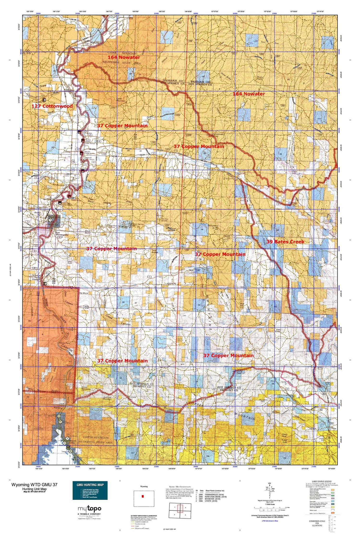
Hunting unit map of Wyoming Game Management Unit WTD-37 with topographic lines and unit boundaries. This topo map features UTM / MGRS and Latitude/Longitude grids, plus public land ownership. It comes folded on waterproof paper. Be fully prepared for your hunt with a MyTopo GMU map!.
This map contains the following named places: 82430,Ackles Fork,Alkali Creek,Andreen Pit,Antelope Creek,Antelope Creek Summer Camp,Big Draw,Big Spring,Birdseye Mountain,Birdseye Pass,Birdseye Station,Black Butte,Black Canyon,Black Sulphur Spring,Black Willow Draw,Blue Hill,Blue Ridge,Blue Springs Draw,Boysen,Boysen Creek,Boysen Peak,Boysen Ridge,Bridger Mountains,Brontley Spring,Brown Spring Draw,Buffalo Basin,Buffalo Canyon,Buffalo Creek,Cedar Mountain,Coal Draw,Copper Glance Group Mine,Copper Mountain,Cottonwood Creek,Cover Slough,Cowboy Mine,Coyote Hill,Crosby Cemetery,Crosby Mine,Day Homestead,De Pass,Deer Canyon,DePass Mine,Devil Slide,Devils Punch Bowl,Ditch Creek,Ditch Creek Canyon,Dornick,Dry Fork,Dye Springs,Eagel Mine,East Fork Ditch Creek,East Fork Jones Creek,East Fork West Bridger Creek,East Kirby Creek,East Thermopolis,East Warm Springs Oil Field,Election Reservoir,Fourmile Bridge,Freeman Draw,Fuller Summer Camp,Gardner Creek,Gold Creek,Gold Nugget Mine,Golden Cabin,Government Mine,Grass Creek,Grass Creek Canyon,Grider Basin,Grider Canyon,Guffy Peak,Guffy Ranch,Hale Number One Mine,Hall Butte,Harvey Pit,Hayes Winter Ranch,Henry Draw,Hot Springs County Memorial Hospital,Hot Springs State Park,Jack Welch Basin,Joe Johns Basin,Johnson Ranch,Johnson Trail,Jones Creek,Jones Creek Canyon,Jones Dam,Jones Ranch,Jones Reservoir,KFNE-TV (Riverton),Kirby,Kirby Creek,Kirby Creek Dam,Kirby Creek Oil Field,Kirby Creek Reservoir,Kirby Ditch,Kirby Reservoir,Lake Creek,Lime Ridge,Little Sand Draw,Little V-H Draw,Lucerne,Lucerne Census Designated Place,Major Basin,Major Basin Draw,Malcolm Spring,McCarthy Well,McGraw Copper Mine,Middle Fork Warm Springs Creek,Milek Family Cemetery,Monument Hill,Moore Springs,Mud Creek,Mud Creek Mine,Murphy Dome Draw,Murphy Dome Oil Field,Nickelson Place,Olsen Draw,Owl Creek,Packsaddle Creek,Park Pit,Philp Ranch,Pinky Reservoir,Pioneer Home,Pixley Reservoir,Potter Butte,Rainbow Terraces,Rathbun Irrigation Number 1 Dam,Rathbun Irrigation Number 1 Reservoir,Rathbun Ranch,Red Canyon,Red Hole,Red Hole Oil Field,Red Springs,Red Springs Draw,Reed Creek,Reed Ranch,Rock Springs,Rock Springs Draw,Rocky Point,Sand Draw,Sanford Ranch,Seaman Hill Reservoir,Shafer Pit,Side Hill Spring,Smoky Row Cemetery,South Fork Warm Springs Creek,South Side Ditch,Stone Mountain,Swallow Ranch,Teepee Fountain,Teeter Canyon,The Block,The Willows,Thermopolis East Division,Thermopolis Hot Springs,Tie Down Flats,Town of East Thermopolis,Town of Kirby,Twin Buttes,Walters Draw,West Bridger Basin,West Fork,West Fork Ditch Creek,West Kirby Creek,West Warm Springs Oil Field,Wild Horse Butte,Wild Horse Butte Oil Field,William Reservoir,Williams-Luman Mine,Winchester,Winchester Cemetery,Winchester Chatham Station,Windy Point,Winter Spring,Woods Basin,Zimmerman Buttes,Zimmerman Draw,Zimmerman Springs


