MyTopo
Wyoming Whitetail Deer GMU 49 Map
Couldn't load pickup availability
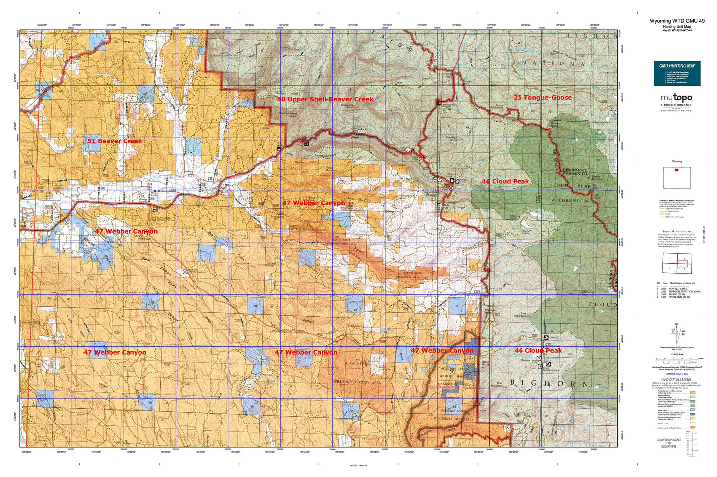
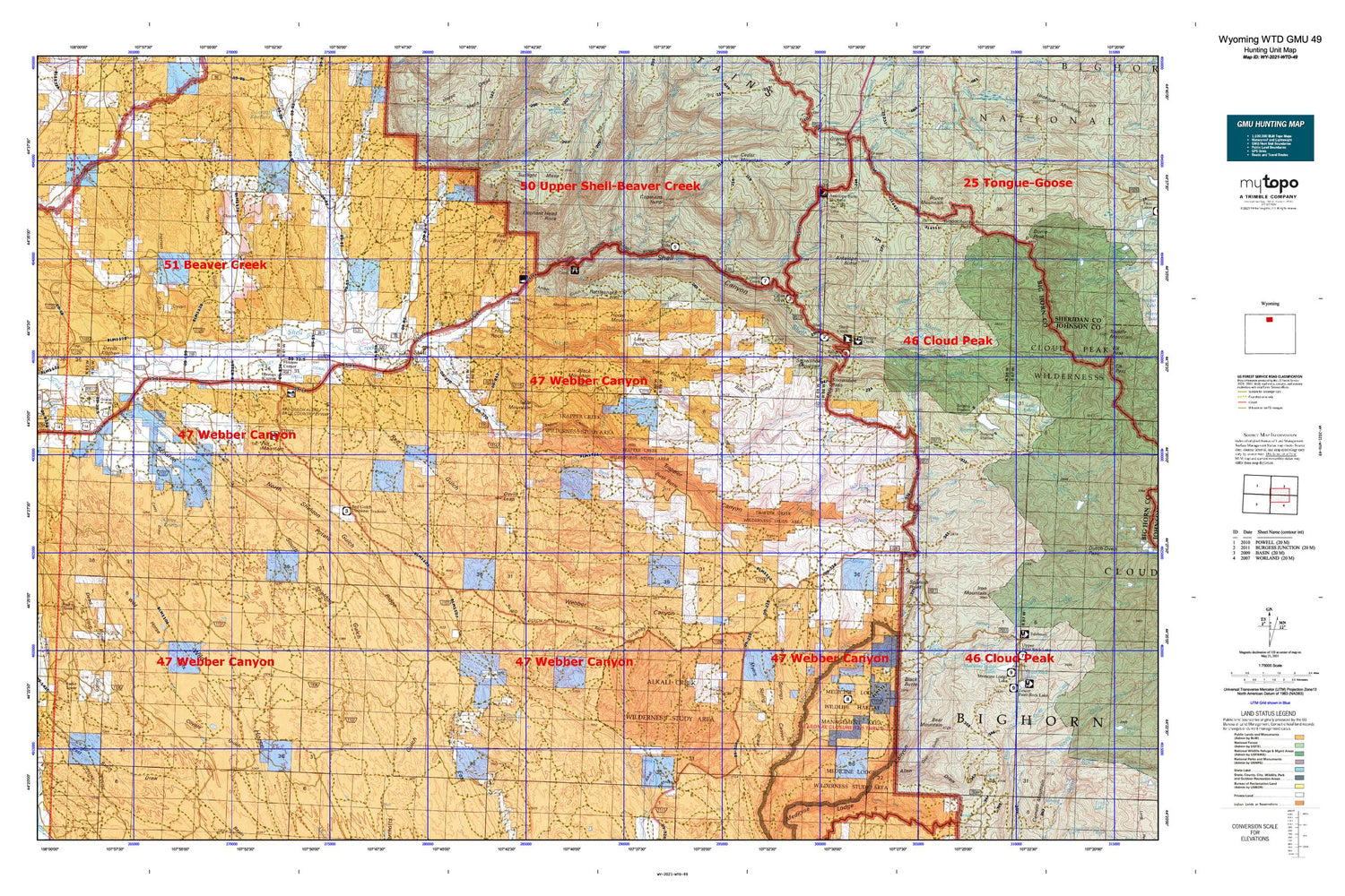
Hunting unit map of Wyoming Game Management Unit WTD-49 with topographic lines and unit boundaries. This topo map features UTM / MGRS and Latitude/Longitude grids, plus public land ownership. It comes folded on waterproof paper. Be fully prepared for your hunt with a MyTopo GMU map!.
This map contains the following named places: 82426,Adelaide Creek,Adelaide Trail,Alkali Flats,Alkali Spring,Allen Draw,Amber Gulch,Anomaly Number Four Mine,Antelope Butte,Antelope Creek,Bald Ridge,Barrel Spring,Battle Creek,Bear Creek Number Two Mine,Bear Gulch,Bear Mountain,Beaver Creek,Bench Trail,Big Hill Group Mine,Bighorn Ski Area,Black Butte,Black Mountain,Blue Ridge Detention Dam,Blue Ridge Reservoir,Brindle Creek,Bruce Mountain,Bull Springs,Bush Butte,Bush Creek,Cabin Creek,Cabin Creek Campground,Calvin Lake,Carey Draw,Carey Reservoir,Cedar Creek,Cedar Mountain,Chimney Rock,Copmans Tomb,Corral Gulch,Cottonwood Creek,Crooked Creek,Crooked Creek Hill,Cry Creek,Dead Horse Gulch,Deer Gulch,Devils Kitchen,Devils Leap,Douglas Draw,Dry Bush Creek,Dry Fork Granite Creek,Dry Fork Horse Creek,Dry Fork White Creek,Elephant Head Rock,Elkhorn Ranch,Ewen Dam,Ewen Pence Gulch Dam,Ewen Pence Gulch Reservoir,Ewen Reservoir,Fender Creek,Flitner Reservoir,Flitners Corner,Fox Mountain,Freezeout,Granite Creek,Granite Creek Campground,Granite Greek Picnic Ground,Greybull Area Number One Mine,Grouse Creek,Hatten Ditch,Herren Gulch,High Line Ditch,Horse Creek,Horse Mountain,Horse Mountain Gulch,Iowa State University Geology Camp,Jack Creek,Johnny Creek,Jones Draw,Jones Reservoir,Kershner Ditch,L. E. Collinwood Bentonite Mine,Lake Ridge,Lamb Oil Field,Long Point,Mail Creek,McKinnon Creek,McNay Creek,Medicine Lodge Big Game Winter Range,Mill Creek,Moraine Creek,Mudstone Claims Mine,Myers Spring,North Fork Bear Gulch,North Sheldon Gulch,North Trapper Creek,Odessa Cemetery,Perkins Dam,Perkins Reservoir,Porter Canal,Porter Gulch,Porter Gulch Area Mine,Post Creek,Post Creek Picnic Area,Potato Draw,Potato Ridge,Potato Ridge Mine,Prairie Dog Spring,Ranger Creek,Ranger Creek Campground,Ranger Creek Ranch,Red Basin,Red Butte,Red Canyon Creek,Red Gulch,Reeves Corner,Reeves Ranch Mine,Round Lake,Ruble Creek,Salt Creek,Sanguine Claim Mine,Sanguine Number Twelve Mine,Scharen Gulch,Sheep Springs,Sheep Springs Canyon,Sheldon Gulch,Shell,Shell Canal,Shell Canal Mine,Shell Canyon,Shell Cemetery,Shell Census Designated Place,Shell Creek Campground,Shell Creek Canyon Mine,Shell Creek Prospect Mine,Shell Creek Ranger Station,Shell Dam,Shell Falls,Shell Falls Observation Point,Shell Post Office,Shell Valley Volunteer Fire Department,Shelly Gulch,Snake Mine,Snowshoe Mountain,Snowshoe Pass,South Fork Bear Gulch,South Sheldon Gulch,South Trapper Creek,Spanish Point,Spanish Point Agate Mine,Split Ear Spring,Spring Creek,Sunlight Canyon,Sunlight Gulch,Sunlight Mesa,Survey Creek,Table Mountain,Taylor Cow Camp,The Arch,Thomas Coulee Reservoir,Thompson Lateral,Torchlight Dome Oil Field,Trapper Canyon,Trapper Creek,Trapper Lodge Ranch,Trone Gulch,Webber Canyon,Whaley Cemetery,Whaley Ditch,White Bottom Spring,White Creek,White Sulphur Spring,Wild Horse Flats,Willett Creek,Willett Lake,Woodchuck Pass