MyTopo
Burchfield Store Alabama US Topo Map
Couldn't load pickup availability
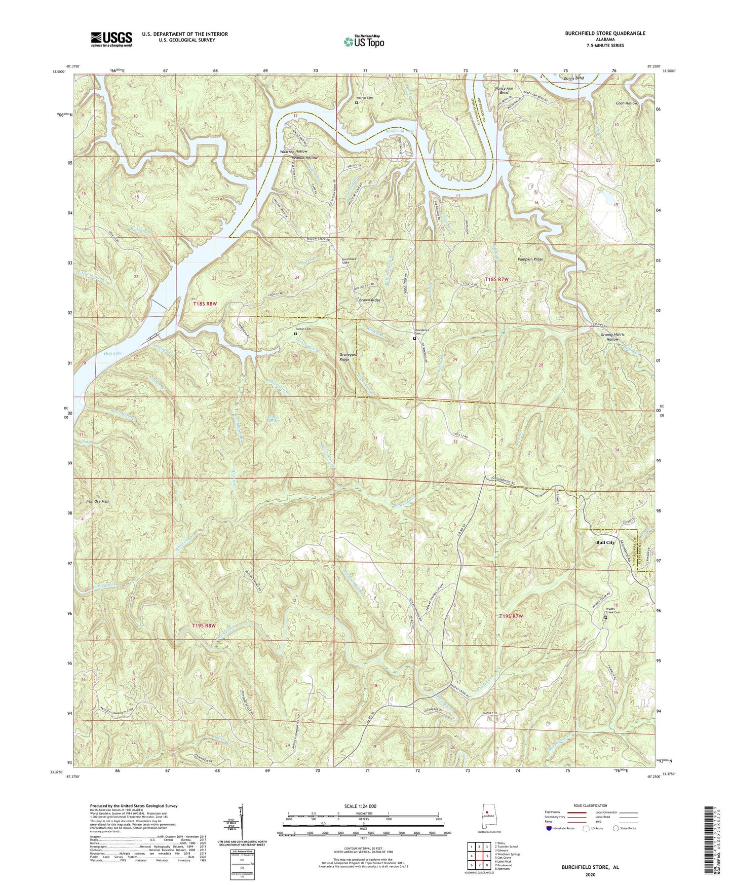
2024 topographic map quadrangle Burchfield Store in the state of Alabama. Scale: 1:24000. Based on the newly updated USGS 7.5' US Topo map series, this map is in the following counties: Tuscaloosa, Jefferson. The map contains contour data, water features, and other items you are used to seeing on USGS maps, but also has updated roads and other features. This is the next generation of topographic maps. Printed on high-quality waterproof paper with UV fade-resistant inks.
Quads adjacent to this one:
West: Windham Springs
Northwest: Wiley
North: Tutwiler School
Northeast: Gilmore
East: Oak Grove
Southeast: Abernant
South: Brookwood
Southwest: Lake Nicol
This map covers the same area as the classic USGS quad with code o33087d3.
Contains the following named places: Allen School, Antioch Church, Bankhead Lake, Big Coal Bed Branch, Big Creek, Big Indian Creek, Big Indian Creek Public Use Area, Big Shoals Camp, Big Yellow Creek, Bradbottom Branch, Brown Ridge, Bull City, Burchfield Branch, Burchfield Store, Burchfield Store High School, Burke Branch, Burton Branch, Camp Aldredge, Camp Hill, Canoe Branch, Cold Branch, Community Camp, Coon Hollow, Devils Den Branch, Dunns Bend, Dunns Camp, Farleys Spring, Fox Creek, Granny Harris Hollow, Graveyard Ridge, Harrigan Branch, Hayes, Howtons Ferry, Iron Ore Mountain, Island Branch, Jackie Watson Redstone Camp, Jackson Branch, Joe Branch, John Hollis Bankhead Lock and Dam, Kings Marina Camp, Kirtley Marine Camp, Light House Camp, Little Indian Creek, Lock Number Eleven, Lock Number Seventeen, Lock Number Sixteen, Nancy Ann Bend, Nathan Branch, Old Lock 16 Public Use Area, Patton Cemetery, Patton Ferry, Pattons Mill, Penney Point Lodge Camp, Poplar Springs Church, Providence, Providence Cemetery, Providence Church, Providence Lookout Tower, Prudes Creek, Prudes Creek Baptist Church Cemetery, Prudes Creek Missionary Baptist Church, Prudes Creek School, Pumpkin Ridge, Redbud Hollow, Shoal Creek, Spring Branch, Squaw Shoals, Steep Creek, Suck Creek, Tan Troff Branch, Thompsons Mill, Turkey Pen Branch, Warrior Cemetery, Warrior Church, Watson Branch, Waxtree Hollow, Whiteoak Creek, Wildcat Branch, Willowstump Branch, Works Branch, Yellow Creek Camp