MyTopo
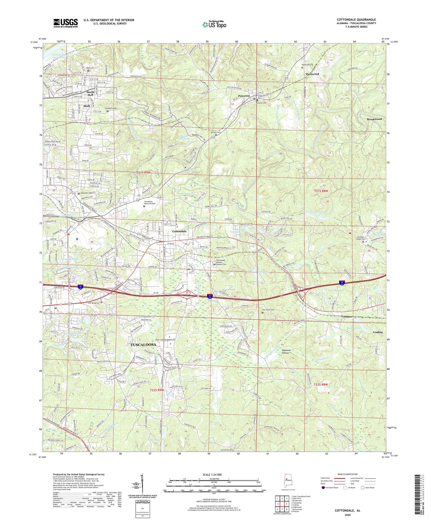
Cottondale Alabama US Topo Map
Couldn't load pickup availability
2024 topographic map quadrangle Cottondale in the state of Alabama. Scale: 1:24000. Based on the newly updated USGS 7.5' US Topo map series, this map is in the following counties: Tuscaloosa. The map contains contour data, water features, and other items you are used to seeing on USGS maps, but also has updated roads and other features. This is the next generation of topographic maps. Printed on high-quality waterproof paper with UV fade-resistant inks.
Quads adjacent to this one:
West: Tuscaloosa
Northwest: Lake Tuscaloosa South
North: Lake Nicol
Northeast: Brookwood
East: Coaling
Southeast: Pearson
South: Duncanville
Southwest: Englewood
This map covers the same area as the classic USGS quad with code o33087b4.
Contains the following named places: Alberta Church of God, Alpine Hills, Altamont, Andrews Chapel Cemetery, Andrews Chapel School, Andrews Chapel United Methodist Church, Apostolic Gospel Church, Arcadia, Arcadia Elementary School, Arrow Wood, Asbury, Banks Villa East, Bankston Cemetery, Bee Branch, Beech Hills, Benville Church, Benville School, Berkley Hills, Bible Methodist Church, Boteler High School, Box Springs, Brentwood, Brewer-Porch Childrens Center, Briarwood, Broadview, Brown School, Bryant High School, Cadillac Estates, Camp Horne, Camp Horne Lake Dam, Camp Horne Lake Dam Number 1, Camp Horne Lake Number 1, Camp Horne Lake Number 2, Canyon Lake Dam, Canyon Lake Dam Upper, Canyon Lake Lower, Canyon Lake Number 2 Dam, Canyon Lake Upper, Canyon Lakes, Chambers Cemetery, Chambers Mill, Cherrywood, Church of Christ, Church of God of Prophecy, Church of the Nazarene, Claymont, Clearview Hills, Clements Road Church, Coaling Fire Department Station 3, Colony Hills, Cottondale, Cottondale Baptist Church, Cottondale Census Designated Place, Cottondale Christian Church, Cottondale Church of the Nazarene, Cottondale Creek, Cottondale Elementary School, Cottondale Methodist Church, Cottondale Nature Garden Cemetery, Cottondale Plaza Shopping Center, Cottondale Post Office, Cottonwood Park, Creek Pit Mine, Cresent Heights, Cumberland Park, Davis-Emerson Middle School, Deep Wood, Dogwood Lake, Druid Hills, Druid Hills United Methodist Church, East Lake, East Lake Dam, East Park, Eastern Gate Baptist Church, Eastern Hills, Eastover, Eastside Freewill Baptist Church, Eastwood Middle School, Echo Lake, Echo Lake Dam, El Dorado East, Elm Ridge, Emerson School, Fairview Church, Faith Community Church, First Assembly of God Church, First United Pentecostal Church, Five Points, Five Points East Shopping Center, Fleetwood, Fleetwood Church, Fleetwood Mine, Forestasia, Frierson Lake, Garners Cemetery, Glenwood Park, Goins Elementary School, Golden Acres, Goree Coal Bed Branch, Goree Mill, Grace Freewill Baptist Church, Green Grove, Grimes, Harris Memorial Methodist Church, Hazelhurst, High Point, Hillcrest Baptist Church, Hillsdale, Hillswood, Hillview, Holt, Holt Baptist Church, Holt Cemetery, Holt Census Designated Place, Holt Elementary School, Holt High School, Holt United Methodist Church, Hope Church, Hopewell Baptist Church, Hopewell Cemetery, Hopewell School, Huntland, Hurricane Baptist Church, Hurricane Hills, Interstate Industrial Park, Judson Park, Keenes Mill, Keenewood, Kennedy Chapel, Kingdom Hall of Jehovahs Witnesses, Lake Grace, Lake Grace Dam, Lake Judson, Laurel Hills, Lavelle Woods, Little Flint Branch, Lynn Haven, Mallard Lake Dam, Mayfair, Mitchell School, Monte Vista, Morning Star Baptist Church, Mothers Branch, Mount Liberty African Methodist Episcopal Zion Church, Mount Liberty School, Mount Olive Church, New Testament Baptist Church, Nichol Hills, Norris Circle, Norris Estates, Oak Grove, Old Mill Trace, Old Salem Baptist Church, Old Salem Cemetery, Olmsted, Opossum Hollow, Oxford Gate, Patton Lake, Patton Lake Dam, Peach Grove, Peterson, Peterson Methodist Church, Peterson Nazarene Church, Peterson Pit Mine, Peterson Post Office, Poes Acres, Praise Freewill Baptist Church, Prudes Mill, Prudes Mill Pond, Radson, Rainey Field Airport, Ruhama Baptist Church, Ruhama Cemetery, Ruhama Church Branch, Saint John African Methodist Episcopal Church, Saint Paul Missionary Baptist Church, Sherwood Forest, Skyland Boulevard Baptist Church, Skyland Plaza Shopping Center, Sniders Spring Branch, Souls Harbor Church, South Holt, South Holt Highlands, Springhill Lake, Springhill Lake Dam, Standridge, Summerfield, The Staffords, Thomas Chapel Methodist Church, Three Branches Estates, Tuscaloosa Christian School, Tuscaloosa Fire Rescue Station 6, Tuscaloosa Fire Rescue Station 9, Tuscaloosa Memorial Park, Tuscaloosa Post Office, Tuscaloosa Primitive Baptist Church, Tuscaloosa Veterans Affairs Medical Center, University of Alabama Golf Course, Village East Shopping Center, WCFT-TV (Tuscaloosa), Weeping Mary African Methodist Episcopal Zion Church, Wesleyan Holiness Church, Westview, Whispering Hills, Willow Swamp Creek, Windsor Drive, Woodhaven Church of the Nazarene, Woodland Forest, Woodland Forest Country Club, Woodland Forest Elementary School, Woodland Hills, Woodland Lake, Woodland Park, Woodland Pines, Woodland Terrace, Woodmont, Woody Clements Stadium, WTUG-FM (Tuscaloosa), ZIP Codes: 35404, 35453