MyTopo
Lake Tuscaloosa South Alabama US Topo Map
Couldn't load pickup availability
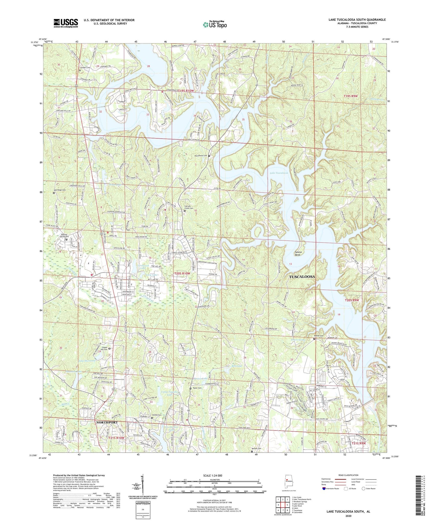
2024 topographic map quadrangle Lake Tuscaloosa South in the state of Alabama. Scale: 1:24000. Based on the newly updated USGS 7.5' US Topo map series, this map is in the following counties: Tuscaloosa. The map contains contour data, water features, and other items you are used to seeing on USGS maps, but also has updated roads and other features. This is the next generation of topographic maps. Printed on high-quality waterproof paper with UV fade-resistant inks.
Quads adjacent to this one:
West: Lake Lurleen
Northwest: Gin Creek
North: Lake Tuscaloosa North
Northeast: Windham Springs
East: Lake Nicol
Southeast: Cottondale
South: Tuscaloosa
Southwest: Coker
This map covers the same area as the classic USGS quad with code o33087c5.
Contains the following named places: AG Hinton Full Gospel Deliverance Church, Appling Bend, Bakers Ford, Beacon Point, Bell Lake, Bethel Cemetery, Bethel Presbyterian Church, Bethel School, Beulah Baptist Church, Beulah Cemetery, Briarcliff, Bridgeview, Browns Spring, Brush Creek, Burnt Pine, Camile Terrace, Camp Tuscoba, Camp Tuscoba Lake, Candlewood, Carolwood Church, Carolwood Estates, Carolwood Lake, Carolwood Lake Dam, Carroll Creek, Carroll Creek Church, Carrolls Creek Baptist Church, Carrolls Creek Cemetery, Carrolls Creek Island County Park, Carrolls Creek Volunteer Fire Department Station 1, Carrolls Creek Volunteer Fire Department Station 2, Carrolls Creek Volunteer Fire Department Station 3, Chambers Mill, Chapel Hill Baptist Church, Chapel Hill Cemetery, Cherokee Shores, Chestnut Hill, Chewalla, City of Northport, Clearwater Estates, Cove Park, Covenant Assembly Church, Cowden Cemetery, Demarest, Dorsey Creek, Driftwood Estates, Edwardian Place, Falls, Flatwoods, Four Winds, Georgena Terrace, Graceland Acres, Hamner Creek, Hamner Estates, High Cliff, Houses Lake, Huntington Place, Huntington Place Elementary School, La Foay School, Ladybug Farm, Lake Cove, Lake Front Village, Lake Hills North, Lake Sherwood, Lake Sherwood Dam, Lake Tuscaloosa, Lake Tuscaloosa Church, Lake Tuscaloosa Dam, Lake Tuscoba Dam, Lakeland Forest, Lakeview Estates, Lakeview Manor, Lakewood, Lakewood Baptist Chapel, Langstons Mill, Lary Lake, Lary Lake Dam, Lavender Acres, Loganwood, Macedonia Cemetery, Macedonia Methodist Church, Mariners Cove, Mary Ann Phelps Activity Center, Monterey Drive, Munny Sokol Park, North Haven, North River Country Club, North River Country Club Estates, North River Yacht Club, North Valley Acres, Northcliff, Northcrest, Northport Fire Rescue Station 2, Northport Fire Rescue Station 4, Northwood Forest, Northwood Lake, Northwood Lake Park, Oak Ridge Cemetery, Pinedale, Piney Grove Mine, Poplar Springs School, Popular Spring Cemetery, Popular Spring Christian Methodist Episcopal Church, Rock Quarry County Park, Sexton Bend, Shirley Cemetery, Shops of Lake Tuscaloosa Shopping Center, Smoke Rise, Sniders Mill, Snyder, Springhill African Methodist Episcopal Zion Church, Stonehedge, Stonehedge Cliffs, Swanson Lake, Swanson Lake Dam, Taylor Cemetery, Thompson Ford, Tierce Creek, Tierces Mill, Turner School, Tuscaloosa County, Tyner, Union Chapel United Methodist Church, Vista Granda, Watermelon Road County Park, Watts Lake, White School, Willow Point, WJRD-AM (Tuscaloosa), Wood Estates, Wood Village, Yacht Club Bay, Yacht Club Bay Dam Number 8, Yacht Club Bay Lake Number 8, Zion Grove Baptist Church, ZIP Code: 35473