MyTopo
Jemison East Alabama US Topo Map
Couldn't load pickup availability
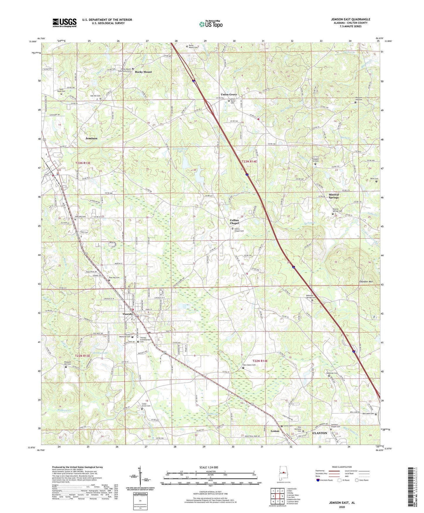
2024 topographic map quadrangle Jemison East in the state of Alabama. Scale: 1:24000. Based on the newly updated USGS 7.5' US Topo map series, this map is in the following counties: Chilton. The map contains contour data, water features, and other items you are used to seeing on USGS maps, but also has updated roads and other features. This is the next generation of topographic maps. Printed on high-quality waterproof paper with UV fade-resistant inks.
Quads adjacent to this one:
West: Jemison West
Northwest: Montevallo
North: Ozan
Northeast: Shelby
East: Lay Dam
Southeast: Clanton East
South: Clanton West
Southwest: Maplesville East
This map covers the same area as the classic USGS quad with code o32086h6.
Contains the following named places: Alabama Music Park, Bell Lane Baptist Church, Bell Lane Cemetery, Bentleys Lake, Calvary Church, Cedar Grove Branch, Cedar Grove Cemetery, Cedar Grove Methodist Church, Cedar Grove School, Cedar Springs Church, Chandler Mountain, Charlotte Creek, Chilton Area Horticulture Sub-Station, City of Jemison, Collins Chapel, Collins Chapel Baptist Church, Collins Chapel Cemetery, Collins Chapel Fire and Rescue, Collins Chapel School, Davis Cemetery, Double Bridges, Fountainhead Lake, Gum Swamp, Hardiman Cemetery, Jacksons Chapel Baptist Church, Jacksons Chapel Cemetery, Jemison, Jemison Church, Jemison Fire Department, Jemison High School, Jemison Police Department, Jemison Post Office, Lake Fountain Head Dam, Lake John Paul, Lake John Paul Dam, Lomax, Lomax Cemetery, Lomax Church, Lomax Church of Christ, Lowerys Chapel, Luby Gore Dam, Luby Gore Lake, Maynard Chapel, Mims Crossroads, Mineral Springs, Mineral Springs Baptist Church, Mineral Springs Cemetery, Mineral Springs School, Mount Pleasant Church, Mullins Mill Post Office, New Bethel Church, New Harmony Cemetery, New Harmony Primitive Baptist Church, New Salem Baptist Church, New Salem Cemetery, New Style Church, Oak Hill Cemetery, Oak Hill Church, Pakan Talahassi, Pate Creek, Peach Queen Camp, Pig Pen Creek, Pine Hill Cemetery, Pleasant Hill Cemetery, Pleasant Hill Church, Ram Branch, Robinson Springs Baptist Church, Robinson Springs Cemetery, Rocky Mount, Rocky Mount Cemetery, Rocky Mount Community Cemetery, Rocky Mount Methodist Church, Rocky Mountain School, Saint Pauls Baptist Church, Saint Pauls Cemetery, Susan Bentley Field, Thompson Chapel, Thorsby, Thorsby Fire Department, Thorsby High School, Thorsby Institute, Thorsby Memorial Cemetery, Thorsby Police Department, Thorsby Post Office, Thorsby Scandinavian Cemetery, Tongue Church, Town of Thorsby, Turkey Creek, Union Church, Union Grove, Union Grove Cemetery, Union Grove Church, Union Grove Fire and Rescue Department, Union Grove Lookout Tower, Unity Church, Varden Branch, ZIP Codes: 35085, 35171