MyTopo
Opelika West Alabama US Topo Map
Couldn't load pickup availability
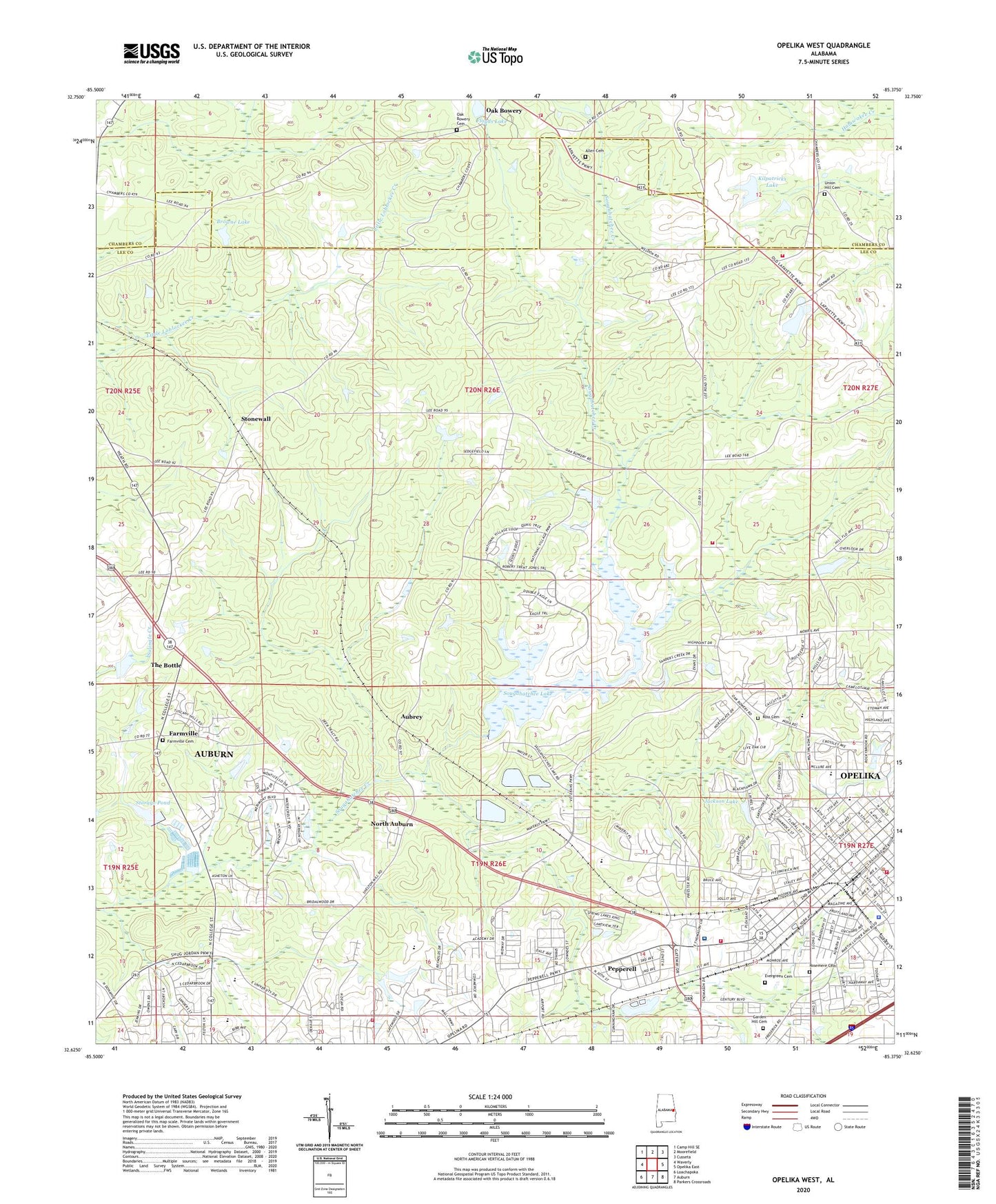
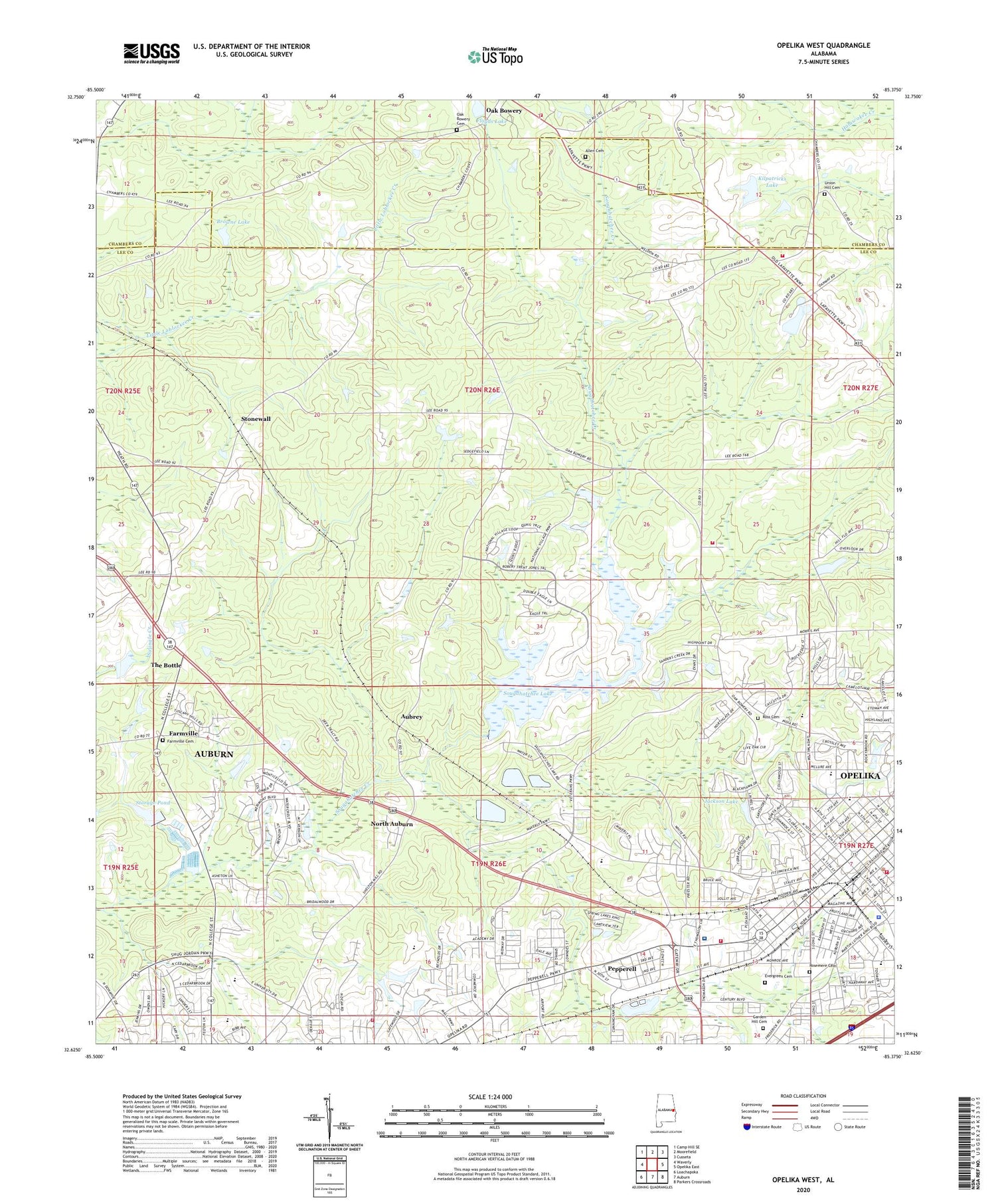
2024 topographic map quadrangle Opelika West in the state of Alabama. Scale: 1:24000. Based on the newly updated USGS 7.5' US Topo map series, this map is in the following counties: Lee, Chambers. The map contains contour data, water features, and other items you are used to seeing on USGS maps, but also has updated roads and other features. This is the next generation of topographic maps. Printed on high-quality waterproof paper with UV fade-resistant inks.
Quads adjacent to this one:
West: Waverly
Northwest: Camp Hill SE
North: Moorefield
Northeast: Cusseta
East: Opelika East
Southeast: Parkers Crossroads
South: Auburn
Southwest: Loachapoka
This map covers the same area as the classic USGS quad with code o32085f4.
Contains the following named places: Allen Cemetery, Alta Vista, Antioch Baptist Church, Aubrey, Auburn Farm Pond Storage Dam, Auburn Fire Department Station 4, Auburn-Opelika Division, Browne Dam, Browne Lake, Carver Elementary School, Cedar Brook, Central Baptist Church, Church of Christ, Church of God, City of Opelika, Clay Floyd Dam, Cliff Junior High School, Collingwood, Covenant Presbyterian Church, Doctor Ranier Lake, East Alabama Hospital, East Alabama Medical Center, Eastview Baptist Church, Emanuel Episcopal Church, Emanuel Holiness Church, Evergreen Cemetery, Farmville, Farmville Baptist Church, Farmville Cemetery, Farmville Volunteer Fire Department, First Assembly of God Church, First Baptist Church, First Freewill Baptist Church, First Presbyterian Church, First United Methodist Church, Fittens Chapel, Five Points, Flat Rock Church, Flat Rock School, Floyds Lake, Garden Hill Cemetery, Geneva Street Historic District, Gold Hill Post Office, Granite Hills, Gwen Mill, Hardaway Street Church of God, Harwell Hills, Head Estates, Hincle Lake, Hinkle Dam, India Lakes, Jackson Lake, Kilpatrick Dam, Kilpatricks Lake, Lake Forest Estates, Lakewood, Midway Plaza Shopping Center, Moore Stadium, Morris Snower Elementary School, North Auburn, North Gate, North Hills, North Side School, Oak Bowery Cemetery, Oak Bowery Heights, Oak Bowery Volunteer Fire Department, Opelika, Opelika Fire Department Station 1, Opelika Fire Department Station 2, Opelika Fire Department Station 3, Opelika Junior High School, Opelika Police Department, Opelika Public School, Parkway Shopping Center, Pepperell, Pepperell Baptist Church, Pepperell Elementary School, Pepperell United Methodist Church, Philadelphia Baptist Church, Pickwood, Plainview Volunteer Fire Department, Railroad Avenue Historic District, Renfro School, Rex Ranier Dam, Ridgecrest Baptist Church, Rocky Brook, Rosemere Cemetery, Ross Cemetery, Roxana School, Saint James Baptist Church, Saint Luke Church, Saint Lukes African Methodist Episcopal Church, Saint Marys Catholic Church, Saint Paul Methodist Church, Saugahatchee Country Club, Scott Academy, Second Avenue Baptist Church, Sougahatchee Dam, Sougahatchee Lake, Southside Church of Christ, Spring Hill Heights, Stonewall, Stonewall School, Storage Pond, The Bottle, Trinity Methodist Church, Union Hill Cemetery, Union Hill Church, Village Hills, Village Mall Shopping Center, WAOA-AM (Opelika), WAUD-AM (Auburn), Westside, WFRI-FM (Auburn), WJHO-AM (Opelika), ZIP Code: 36801