MyTopo
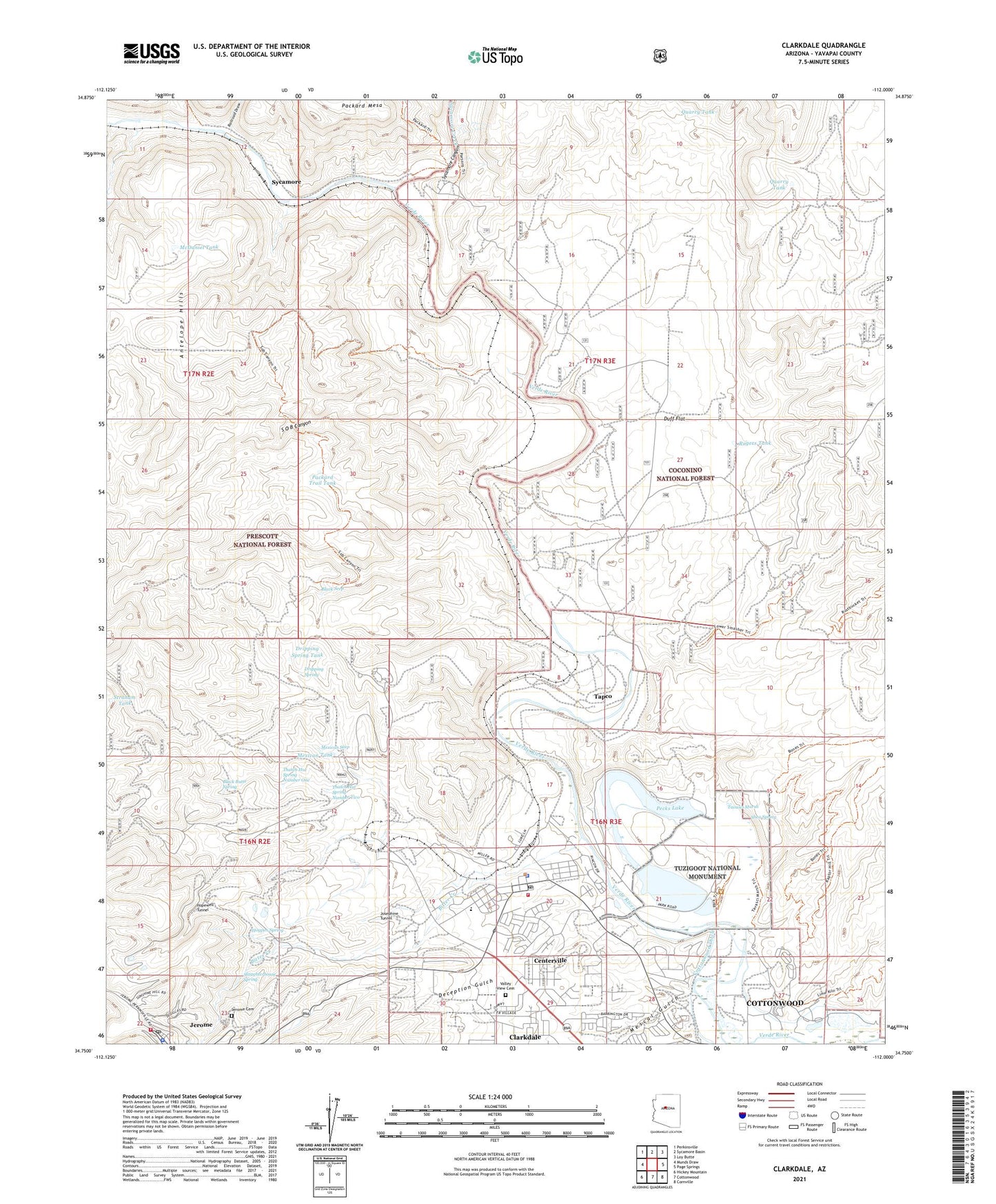
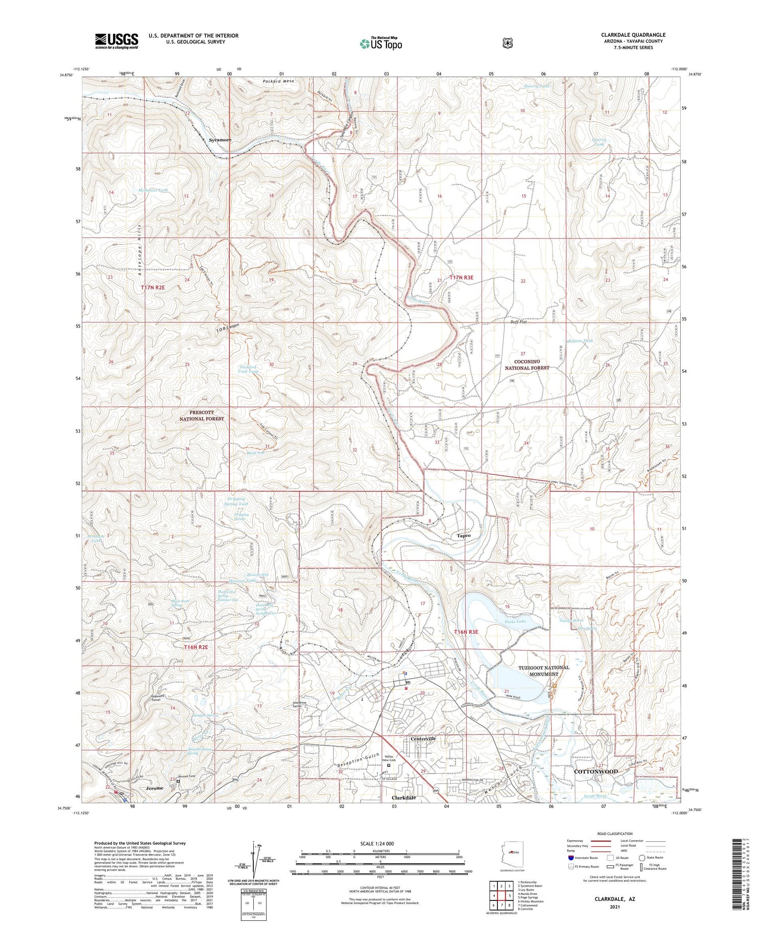
Clarkdale Arizona US Topo Map
Couldn't load pickup availability
Also explore the Clarkdale Forest Service Topo of this same quad for updated USFS data
2021 topographic map quadrangle Clarkdale in the state of Arizona. Scale: 1:24000. Based on the newly updated USGS 7.5' US Topo map series, this map is in the following counties: Yavapai. The map contains contour data, water features, and other items you are used to seeing on USGS maps, but also has updated roads and other features. This is the next generation of topographic maps. Printed on high-quality waterproof paper with UV fade-resistant inks.
Quads adjacent to this one:
West: Munds Draw
Northwest: Perkinsville
North: Sycamore Basin
Northeast: Loy Butte
East: Page Springs
Southeast: Cornville
South: Cottonwood
Southwest: Hickey Mountain
This map covers the same area as the classic USGS quad with code o34112g1.
Contains the following named places: A and A Shaft, American Cement Corporation Substation, Antelope Hills, Bitter Creek, Black Butte Spring, Black Seep, Centerville, Clark Memorial Library, Clarkdale, Clarkdale - Jerome School, Clarkdale Baptist Church, Clarkdale Elementary School, Clarkdale Fire District Station 21, Clarkdale Junior High School, Clarkdale Park, Clarkdale Police Department, Clarkdale Post Office, Clarkdale Railroad Station, Coon Tank, D K Well, Daisy, Dead Horse Ranch State Park, Deception Gulch, Dripping Spring, Dripping Spring Tank, Duff Flat, Dundee Shaft, Hogpen Spring, Hopewell Tunnel, Jerome Fire Department, Jerome Police Department, Jerome Post Office, Jerome State Historic Park, Jerome State Historical Mine Park Museum, Jerome Wastewater Treatment Plant, Josephine Tunnel, KCRJ-FM (Cottonwood), KSMK-FM (Cottonwood), Lampliter Village Mobile Home Park, McDaniel Tank, Mescal Gulch, Mexican Seep, Mexican Tank, Packard Ranch, Packard Trail Tank, Pecks Lake, Phoenix Cement Plant, Pine Shadows Golf Course, Quarry Tank, Railroad Draw, Rogers Tank, S O B Canyon, Saint Thomas of the Valley Episcopal Church, Shea Spring, Slaughterhouse Spring, Straham Tank, Sycamore, Sycamore Canyon, Sycamore Creek, Sycamore Siding, Tapco, Tapco Power Plant and Substation, Tapco Railroad Station, Tavasci Marsh, Texas Shaft, Thatch Hut Spring Number One, Thatch Hut Spring Number Two, Town of Clarkdale, Tuzigoot National Monument, Tuzigoot Trail, United Verde Mine, Valley View Cemetery, Verde Valley Country Club, Verde Valley Lookout, ZIP Code: 86324