
MyTopo
Yuma East Arizona US Topo Map
Couldn't load pickup availability
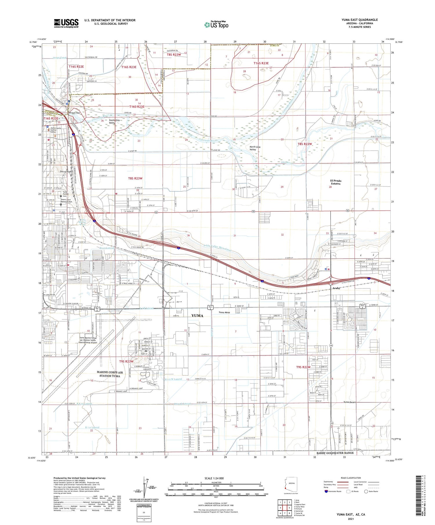
2021 topographic map quadrangle Yuma East in the states of Arizona, California. Scale: 1:24000. Based on the newly updated USGS 7.5' US Topo map series, this map is in the following counties: Yuma, Imperial. The map contains contour data, water features, and other items you are used to seeing on USGS maps, but also has updated roads and other features. This is the next generation of topographic maps. Printed on high-quality waterproof paper with UV fade-resistant inks.
Quads adjacent to this one:
West: Yuma West
Northwest: Araz
North: Bard
Northeast: Laguna Dam
East: Fortuna
Southeast: Fortuna SW
South: Yuma SE
Southwest: Somerton
Contains the following named places: Amerischools Academy, Araby, Araby Acres Mobile Home Park, Araby Road Overpass, Arizona Game and Fish Region IV Office, Arizona Inspection Station, Arizona State Highway Patrol District 4 - Yuma, Arizona West Recreational Vehicle Park, B 3.7 Lateral, B 3.8 Lateral, B 5.5 W Lateral, B 6.2 E Lateral, B 7.0 Lateral, B 8.0 N Lateral, B 8.55 Lateral, B Canal, Bible Baptist Church, Big Curve Shopping Center, C W McGraw Elementary School, Calvary Baptist Church, Calvary Baptist School, Calvary Chapel of Yuma, Calvary Temple of Christ, Carnegie Library, Champion Christian Church, Christ Lutheran Church, City of Yuma Jones and Main Water Treatment Plant, Community Christian Church, Desert Lawn Memorial Park, Desert Mesa Elementary School, Desert Royal Mobile Park, Desert View Academy, East Yard, El Prado Estates Census Designated Place, First Church of Christ Scientist, First United Methodist Church, Fort Yuma Indian Hospital, Generations Church, Gila Center, Gila Ridge High School, Gila River, Gila Vista Junior High School, Grace Bible Fellowship Church, Gwyneth Ham Elementary School, Harvest Preparatory Academy, Iglesia Ade Nazareno, Immanuel Southern Baptist Church, J C Silver Spur Rodeo Grounds, James B Rolle Elementary School, Kennedy Memorial Park, KYXI-FM (Yuma), KZPL-FM (Yuma), Laguna Mobile Home Park, Marine Corps Air Station Yuma, Melody Mobile Court, Mount Zion Church, North End Community Center, North Gila Valley, Osage Canal, Patio, Prison Hill, Public Health Services Health Center Fort Yuma Service Unit, Quechan Tribal Police Department, Reservation Levee, Riverside Park, Rural / Metro Fire Department Station 9, Rural Metro Fire Department Station 1, Saint Thomas Yuma Indian Mission, San Pasqual Middle School, San Pasqual School, San Pasqual Valley Elementary School, Sierra Pacific Mobile Home Park, Sierra Prieta, Sierra Vista Presbyterian Church, South Gila Valley, South Gila Valley Main Canal, Southwestern Christian School, Stone Ridge Church, Sun Vista Resort Mobile Home Park, Sunrise Mobile Home Estates, Sunset Mobile Home Park, World Harvest Church of Yuma, Yuma, Yuma Army Air Field, Yuma City Hall, Yuma County Adult Detention Center, Yuma County Fairgrounds, Yuma County Sheriff's Office, Yuma Courthouse, Yuma Division, Yuma Fire Department Station 1, Yuma Fire Department Station 3, Yuma Fire Department Station 5, Yuma Golf and Country Club, Yuma Helicopters, Yuma Lutheran School, Yuma Main Canal, Yuma Marine Corps Air Station Post Office, Yuma Marine Corps Air Station/Yuma International Airport, Yuma Mesa, Yuma Mineral Spring, Yuma Missionary Baptist Church, Yuma Pioneer Cemetery, Yuma Police Department, Yuma Railroad Station, Yuma Territorial Prison, Yuma Territorial Prison State Historic Park


