MyTopo
Yuma West Arizona US Topo Map
Couldn't load pickup availability
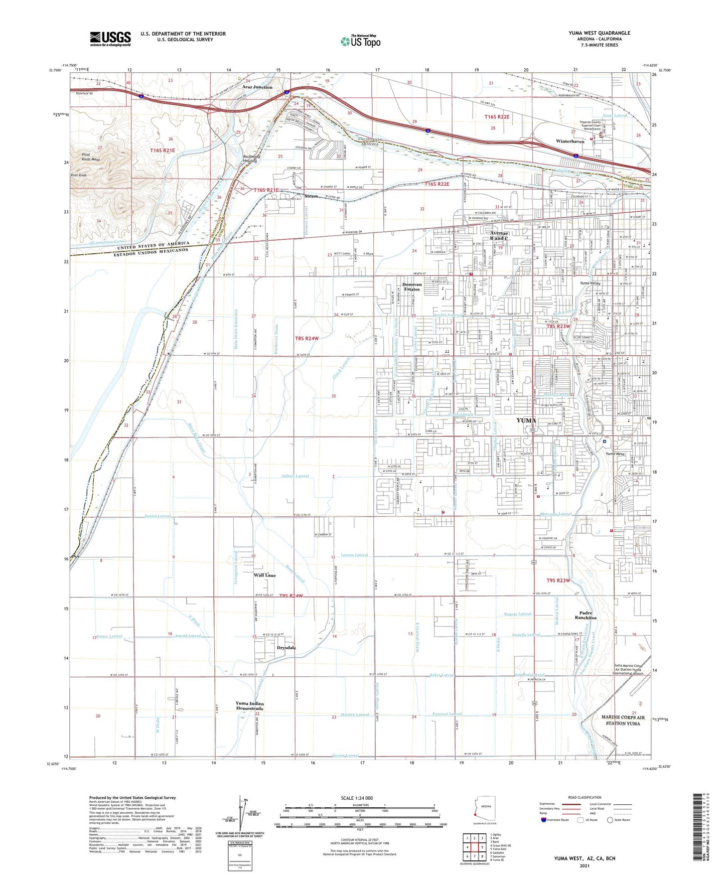
2021 topographic map quadrangle Yuma West in the states of Arizona, California. Scale: 1:24000. Based on the newly updated USGS 7.5' US Topo map series, this map is in the following counties: Yuma, Imperial. The map contains contour data, water features, and other items you are used to seeing on USGS maps, but also has updated roads and other features. This is the next generation of topographic maps. Printed on high-quality waterproof paper with UV fade-resistant inks.
Quads adjacent to this one:
West: Grays Well NE
Northwest: Ogilby
North: Araz
Northeast: Bard
East: Yuma East
Southeast: Yuma SE
South: Somerton
Southwest: Gadsden
Contains the following named places: Alamo Canal, Alice Byrne Elementary School, Andrade, Apostolic Assembly, Araz Junction, Araz Wash, Arnold Lateral, Arroyo Dunes Golf Course, Auxiliary Supply Canal, Avenue B and C Census Designated Place, Aztec High School, Baker Lateral, Bridge Park, Calvary Lutheran Church, Camp Pilot Knob, Capri Mobile Park, Carver Park, Centennial Middle School, Central Canal, Central Church of Christ, Central Drain, Central Stub Number One, Central Stub Number Two Drain, Chaparral Mobile Home Park, Christ the Redeemer Anglican Church, Church of Christ, Cibola High School, City of North Figueroa Water Pollution Control Facility, City Park, Cloyd Lateral, Cocopah Golf Course, Cocopah Recreational Vehicle Resort, Cooper Lateral, Crane Middle School, Daniel Lateral, Desert Palms Mobile Estates, Donovan Estates Census Designated Place, Donovan Lateral, Drysdale Census Designated Place, Dunes West Mobile Home Park, East Central Drain, East Drain, East Drain Extension, East Main Canal, Educational Opportunity Center, Elevenmile Spillway, Elohim Baptist Church, Emerald Springs Retirement and Assisted Living Community, Faith Baptist Church, Faith Lutheran Church, First Christian Church, First Church of the Nazarene, First Presbyterian Church, Flint Lateral, Fourth Avenue Junior High School, Friendly Acres Mobile Home Park, Gardenhire Drain, Gary A Knox Elementary School, George Lateral, George Washington Carver Elementary School, Gibson Lateral, Gilbert Lateral, Greer Lateral, H L Suverkrup Elementary School, Hanlon Heading, Hanna Lateral, Harmon Lateral, Haupt Lateral, Hayden Lateral, Howe Lateral, Iglesia Bautista Conservadora, Iglesia El Rio, Immaculate Conception Church, Immaculate Conception Elementary School, Imperial County Sheriff's Office Winterhaven Station, Ironwood Golf Course, Joe Henry Memorial Park, Jordan Lateral, KBLU-AM (Yuma), Kent Lateral, KEZC-AM (Yuma), Kingdom Hall of Jehovahs Witnesses, KJOK-FM (Yuma), Kofa High School, KTTI-FM (Yuma), KVOY-AM (Yuma), Latino Americano Park, Lawler Lateral, Life Care Center of Yuma, Livingston Lateral, Lorona Lateral, Luding Siding, Main Drain Extension, Main Outlet Drain, Maranatha Baptist Church, Marble Lateral, Martin Lateral, Mary E Post Elementary School, Maxey Lateral, Mesa Terrace Mobile Estates, Mesquite Elementary School, Miller Lateral, Modest Lateral, Morelos Dam, Morningside Southern Baptist Church, North Drain, Northwest Drain, Nugent Lateral, O C Johnson Elementary School, Oasis Church, Old Araz Stage Depot, Padre Ranchitos Census Designated Place, Palm Garden Estates Mobile Home Park, Palm View Rehabilitation and Care Center, Palmcroft Elementary School, Pancrazi Lateral, Patterson Lateral, Pecan Grove Elementary School, Pilot Knob Check and Wasteway, Pilot Knob Hydro-electric Plant, Pilot Knob Mesa, Potter Lateral, Potter's House Christian Church, Power House Church of God, Prince of Peace Lutheran Church, Pueblo Elementary School, R Pete Woodard Junior High School, Rancho Viejo Elementary School, Ray Smucker Park, Rock Church, Rockwood Heading, Ronald Reagan Fundamental School, Roosevelt Elementary School, Rose Lateral, Rose of Sharon Church of God, Rural / Metro Fire Department Station 3, Rural / Metro Fire Department Station 5, Saint Francis of Assisi School, Saint Francis of Assissi Parish, Saint Paul's Episcopal Church, Salida del Sol School, Sanguinetti Athletic Field, Sanguinetti Memorial Park, Second Missionary Baptist Church, Sioux Lateral, Southgate Mall, Steam, Stofella Lateral, Sunny Acres Mobile Park, Thacker Lateral, Trinity United Methodist Church, Union Baptist Church, University of Arizona Agricultural Experiment Station, Valley Baptist Church, Valley Horizon Elementary School, Vista Alternative High School, Wall Lane Census Designated Place, West Main Canal, Westward Village Mobile Park, Willets Siding, Winsor Lateral, Winterhaven, Winterhaven Census Designated Place, Winterhaven Fire Protection District, Winterhaven Post Office, Yakima Lateral, Yarwood Lateral, Yocum Lateral, Yucca Powerplant, Yuma Adventist Christian School, Yuma Catholic High School, Yuma Civic and Convention Center, Yuma County Juvenile Home, Yuma County Sheriff's Office District 2, Yuma Fire Department Station 2, Yuma Fire Department Station 4, Yuma Fire Department Station 6, Yuma First Assembly of God, Yuma Foursquare Church, Yuma High School, Yuma Indian Homesteads, Yuma Municipal Golf Course, Yuma Nursing Center, Yuma Post Office, Yuma Regional Medical Center, Yuma Regional Medical Center Heliport, Yuma Valley Church of Christ, ZIP Code: 85364