MyTopo
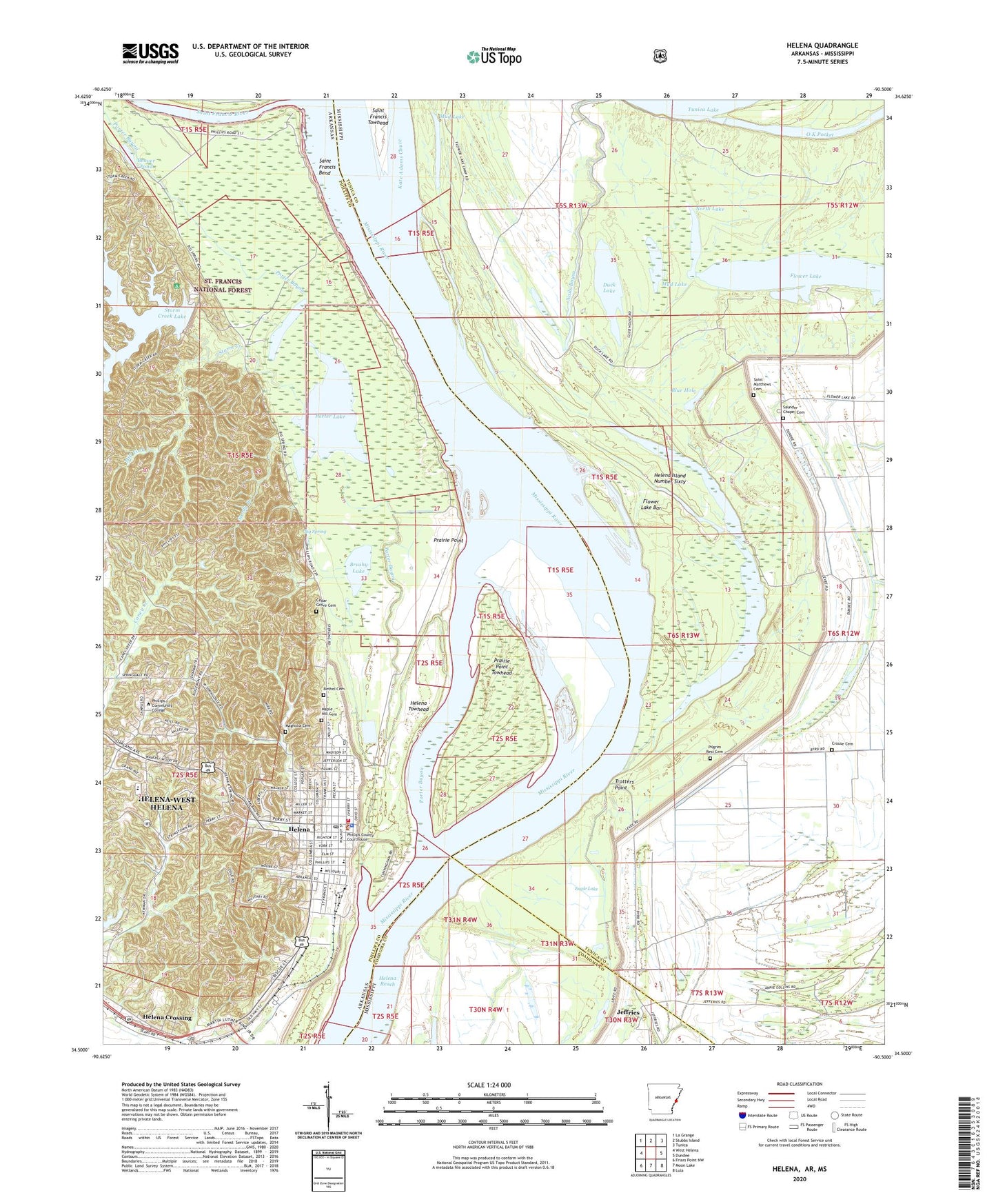
Helena Arkansas US Topo Map
Couldn't load pickup availability
Also explore the Helena Forest Service Topo of this same quad for updated USFS data
2024 topographic map quadrangle Helena in the states of Mississippi, Arkansas. Scale: 1:24000. Based on the newly updated USGS 7.5' US Topo map series, this map is in the following counties: Phillips, Tunica, Coahoma. The map contains contour data, water features, and other items you are used to seeing on USGS maps, but also has updated roads and other features. This is the next generation of topographic maps. Printed on high-quality waterproof paper with UV fade-resistant inks.
Quads adjacent to this one:
West: West Helena
Northwest: La Grange
North: Stubbs Island
Northeast: Tunica
East: Dundee
Southeast: Lula
South: Moon Lake
Southwest: Friars Point NW
Contains the following named places: Arkansas Street Fire Station, Battery A, Battery B, Battery C, Battery D, Beaver Pond, Beech Street Historic District, Bethel Cemetery, Big Spring, Blue Hole, Brushy Lake, Calvary Baptist Church, Calvary Church, Calvary School, Cedar Grove Cemetery, Centennial Baptist Church, Cherry Street Historic District, City of Helena-West Helena, Corder Chapel, Crouse Cemetery, Crowley Ridge Overlook, Delta Cultural Center, Duck Lake, Eagle Lake, Eagle Landing, East Arkansas Mental Health Center, Eliza Miller Park, Estevan Hall, Fern Hill Fire Station, First Baptist Church, First United Methodist Church, Flower Lake, Flower Lake Bar, Fort Curtis, Glendale, Helena, Helena City Hall, Helena Crossing, Helena Fire Department, Helena Hospital, Helena Island Number Sixty, Helena Police Department, Helena Post Office, Helena Public Library, Helena Reach, Helena Revet, Helena Towhead, Helena-West Helena, Heritage Hill Pond, Heritage Hill Pond Dam, Holiday Hills, Hornor Neck, Hubbard School, J F Wahl Elementary School, Jefferson Elementary School, Jeffries, Magnolia Cemetery, Maple Hill Cemetery, Midland Heights, Mill Fork, Morning Star Church, Mouth of Saint Francis Landing, Mud Lake, Nails Bayou, Nash Landing, North Lake, Northend School, O K Pocket, Oak Forest, Old Peach Trees, Old River Chute, Perry Street Historic District, Phillips County Community Center, Phillips County Community College, Phillips County Courthouse, Phillips County Museum, Phillips County Sheriff's Office, Pilgrim Rest Cemetery, Pilgrim Rest Church, Porter Bayou, Porter Lake, Prairie Point, Prairie Point Dikes, Prairie Point Towhead, Prospect Church, Prospect School, Saint Francis Bend, Saint Francis Revet, Saint Francis River, Saint Francis Towhead, Saint Johns Episcopal Church, Saint Matthews Cemetery, Sandy Branch, Saunder Chapel Cemetery, Silver Cloud Church, Springdale Church, State Levee, Stephens School, Storm Creek, Storm Creek Lake, Storm Creek Lake Campground, Storm Creek Lake Dam, Township of L'Anguille, Township of Saint Francis, Trotter Landing, Trotter Landing Revetment, Trotters Point, Wahl Elementary School