MyTopo
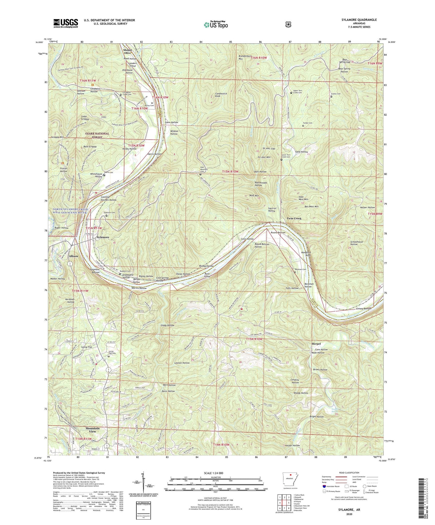
Sylamore Arkansas US Topo Map
Couldn't load pickup availability
Also explore the Sylamore Forest Service Topo of this same quad for updated USFS data
2024 topographic map quadrangle Sylamore in the state of Arkansas. Scale: 1:24000. Based on the newly updated USGS 7.5' US Topo map series, this map is in the following counties: Stone, Izard. The map contains contour data, water features, and other items you are used to seeing on USGS maps, but also has updated roads and other features. This is the next generation of topographic maps. Printed on high-quality waterproof paper with UV fade-resistant inks.
Quads adjacent to this one:
West: Fiftysix
Northwest: Calico Rock
North: Boswell
Northeast: Melbourne
East: Guion
Southeast: Marcella
South: Mountain View
Southwest: Mountain View SW
This map covers the same area as the classic USGS quad with code o35092h1.
Contains the following named places: Allison, Allison - Sylamore Volunteer Fire Station 1, Allison - Sylamore Volunteer Fire Station 2, Allison - Sylamore Volunteer Fire Station 3, Allison - Sylamore Volunteer Fire Station 4, Arkins, Assembly of God Church, Bailey Hollow, Bald Scrappy, Barn Hollow, Bear Spring Gap, Beckham Cemetery, Beckman Hollow, Ben West Mountain, Bishop Hollow, Brandenburg, Brandenburg Mountain, Bright Hollow, Brown Hollow, Buck Island, Candlestick Knob, Canning Kitchen Hollow, Cave Hollow, Cedar Scrappy, Chisholm Hollow, Church of Christ, Cold Springs Hollow, Condrey Hollow, Cove Hollow, Dark Hollow, Davis Hollow, Dry Creek, East Livingston Creek, East Twin Creek, Falls Hollow, Farber Cemetery, Gann Hollow, Glady Hollow, Graveyard Hollow, Greasy Bottom, Gulley Cemetery, Handford Bluff, Haney Hollow, Harper Hollow, Harris Bottom, Harris Cemetery, Hell Creek, Herpel, Isaac West Mountain, Jeffrey Cemetery, Johnson Hollow, Landers Island, Lawson Hollow, Levisy Flat, Levisy Flat Cemetery, Livingston Creek, Livingston Creek Cemetery, Lower Twin Creek Cemetery, Nesbitt Spring, North Sylamore Creek, Old House Hollow, Ozark Folk Center, Pelham Creek, Perrins Ferry, Polk Mountain Cemetery, Rattlesnake Hollow, Reed Hollow, Ripley Hollow, Roper Hollow, Round Bottom, Round Bottom Hollow, Ruddells, Ruddells Cemetery, Sand Hollow, Scrappy Mountain, Sheep Hollow, Sir Alec Gap, Sir Alec Mountain, South Sylamore Creek, Squirrel Hollow, Sylamore, Sylamore Baptist Church, Sylamore Bottom, Sylamore Cemetery, Sylamore Ranger District Office, Township of Washington, Township of White River, Twin Creek, Upper Twin Creek Cemetery, Wade Hollow, Walker Hollow, Warren Branch, Warren Hollow, West Livingston Creek, West Twin Creek, White River Airport, Whitehouse Hollow, Wildcat Hollow, Wolf Mountain, Woody Hollow