MyTopo
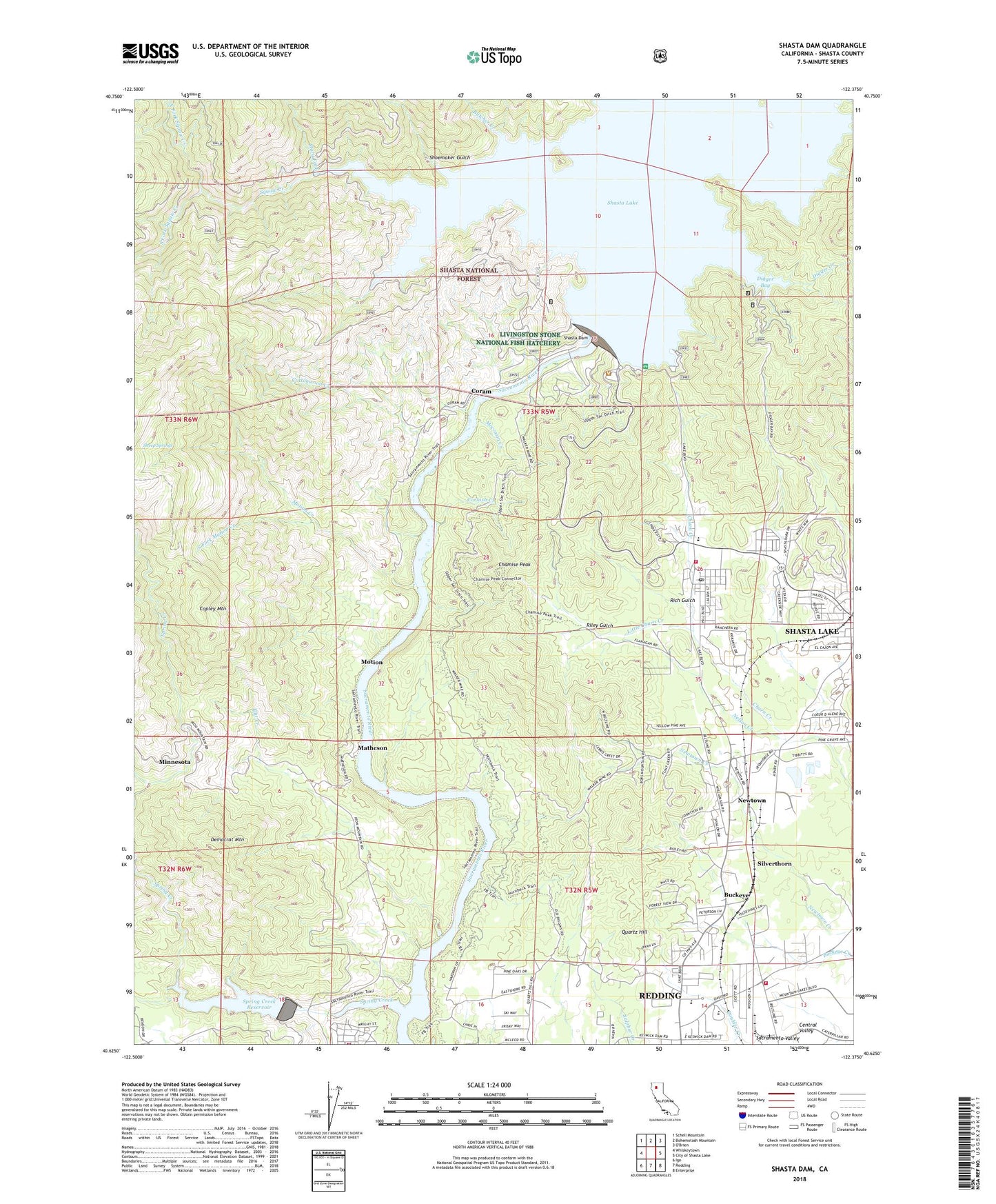
Shasta Dam California US Topo Map
Couldn't load pickup availability
Also explore the Shasta Dam Forest Service Topo of this same quad for updated USFS data
2023 topographic map quadrangle Shasta Dam in the state of California. Scale: 1:24000. Based on the newly updated USGS 7.5' US Topo map series, this map is in the following counties: Shasta. The map contains contour data, water features, and other items you are used to seeing on USGS maps, but also has updated roads and other features. This is the next generation of topographic maps. Printed on high-quality waterproof paper with UV fade-resistant inks.
Quads adjacent to this one:
West: Whiskeytown
Northwest: Schell Mountain
North: Bohemotash Mountain
Northeast: O'Brien
East: City of Shasta Lake
Southeast: Enterprise
South: Redding
Southwest: Igo
This map covers the same area as the classic USGS quad with code o40122f4.
Contains the following named places: Akers Prospect, American Medical Response Station 4, Balaklaia Mine, Benson Mine, Boulder Creek, Buckeye, Buckeye Park, Buckeye School of the Arts, Butcher Creek, Centimundi Boat Launching Ramp, Central Valley Cemetery, Chamise Peak, Churntown, City of Shasta Lake, Copley Mountain, Coram, Cornish Creek, Cottonwood Creek, Democrat Mountain, Digger Bay Marina, Dry Creek Trail, Dry Fork, Fishermans Point Picnic Site, Flat Creek, Frost Gulch, Government Camp, Hart, Kennett, King Copper Prospect, Little Churn Creek, Livingston Stone National Fish Hatchery, Mary Fork, Matheson, Minnesota, Moccasin Creek, Motion, Motion Creek, National Mine, Nelson Creek, Newtown, North Fork Squaw Creek, Park Villa Mobile Home Estates, Quartz Hill, Quartz Point Mobile Home Park, Redding Fire Department Station 6, Rich Gulch, Riley Gulch, Shasta Dam, Shasta King Mine, Shasta Lake Fire Protection District Station 3, Shasta Lake Mobile Home Park, Sheep Springs, Shoemaker Gulch, Silverthorn, South Fork Motion Creek, South Fork Spring Creek, South Fork Squaw Creek, Spreadeagle Mine, Spring Creek, Spring Creek Dam, Spring Creek Reservoir, Spring Creek School, Squaw Creek, Summit City, Summit City Post Office, Toyon Elementary School, Twin Lakes Mobile Estates, Uncle Sam Mine, Vista House, Walker Mine, Whitehouse, Wintu Bay, Wintu Creek, ZIP Code: 96019