MyTopo
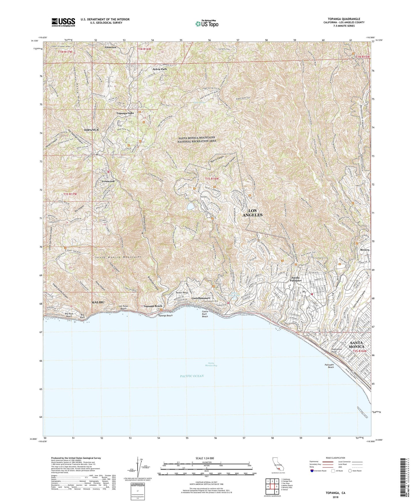
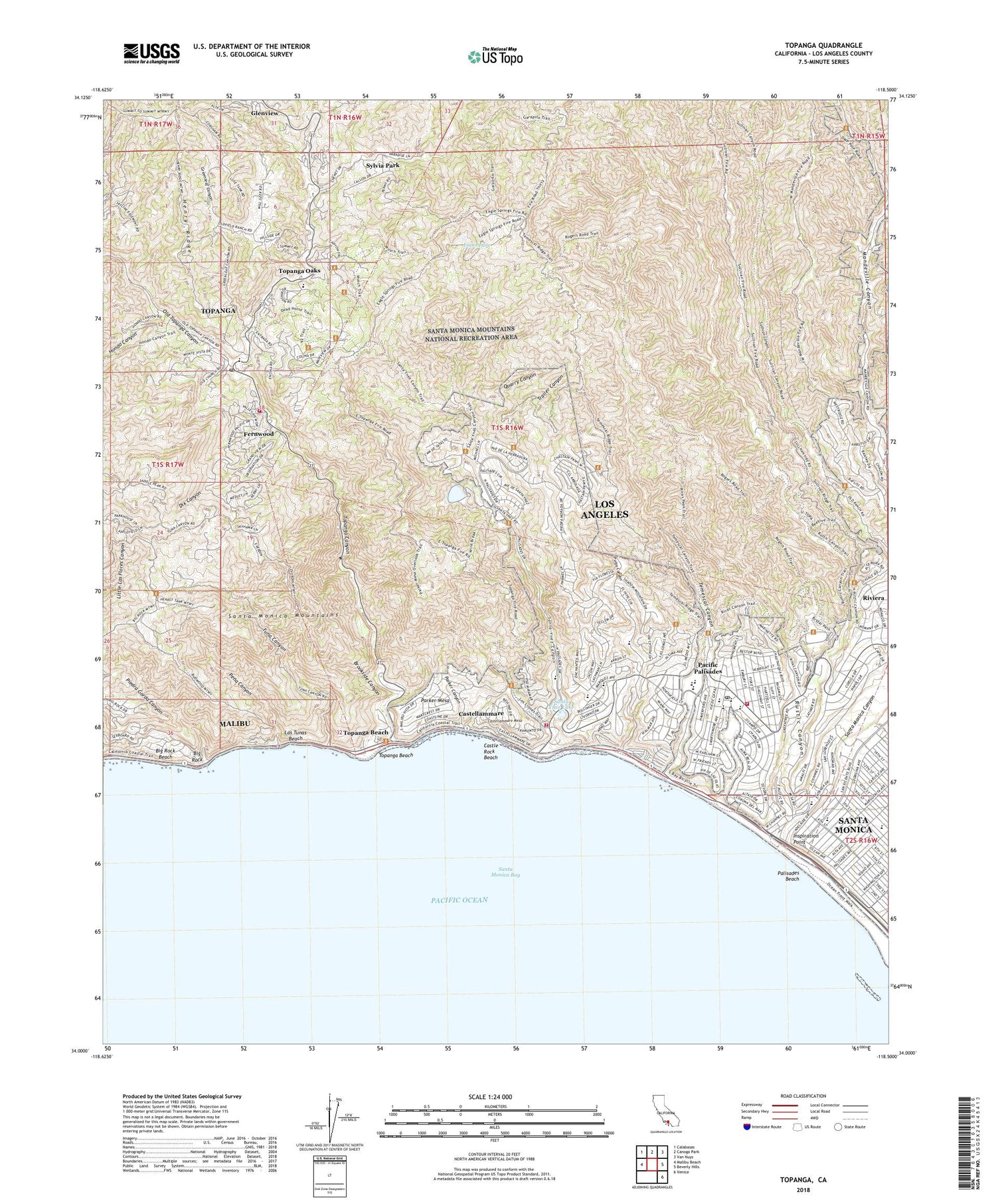
Topanga California US Topo Map
Couldn't load pickup availability
2022 topographic map quadrangle Topanga in the state of California. Scale: 1:24000. Based on the newly updated USGS 7.5' US Topo map series, this map is in the following counties: Los Angeles. The map contains contour data, water features, and other items you are used to seeing on USGS maps, but also has updated roads and other features. This is the next generation of topographic maps. Printed on high-quality waterproof paper with UV fade-resistant inks.
Quads adjacent to this one:
West: Malibu Beach
Northwest: Calabasas
North: Canoga Park
Northeast: Van Nuys
East: Beverly Hills
Southeast: Venice
This map covers the same area as the classic USGS quad with code o34118a5.
Contains the following named places: Almar Plaza, Asilomar Park, Barton School, Big Rock, Big Rock Beach, Boca De Santa Monica, Brookside Canyon, Camp Josepho, Camp Wildwood, Canyon Elementary School, Castellammare, Castellammare Mesa, Castle Rock Beach, Circle E Ranch, City of Santa Monica, Claude Parker Ranch, Community United Methodist Church, Conference Grounds, Corpus Christian School, Dix Canyon, Eagle Spring, Eames House, Elkhorn Camp, Fernwood, Garapito Creek, Glenview, Greenleaf Canyon, Henry Ridge, Hill and Dale Nursery and Kindergarten, Hondo Canyon, Inceville, Inspiration Point, J Paul Getty Museum, J W Wisda 1-067 Dam, Jonathan Club, Las Tunas Beach, Los Angeles County Fire Department Station 69, Los Angeles Fire Department Fire Station 69, Los Angeles Fire Department Station 23, Natural Arch, Old Topanga Canyon, Pacific Palisades, Pacific Palisades Auto Camp, Pacific Palisades Elementary School, Pacific Palisades Post Office, Palisades Beach, Palisades Branch Los Angeles Public Library, Palisades Charter High School, Palisades Elementary School, Palisades Park, Parker Canyon, Parker Mesa, Pena Canyon, Piedra Gorda Canyon, Polo Field, Presbyterian Conference Grounds, Pulga Canyon, Quarry Canyon, Racquet Country Club, Rivas Canyon Park, Riviera, Riviera Country Club, Riviera Reservoir 1043 Dam, Roosevelt Elementary School, Rustic Canyon, Rustic Canyon Park, Rustic Canyon Recreation Center, Salt Air Club, San Vicente Y Santa Monica, Sand and Sea Club, Santa Maria Creek, Santa Monica Canyon, Santa Monica Division, Santa Monica Medical Center, Santa Monica State Beach, Santa Ynez Canyon, Santa Ynez Canyon 6-047 Dam, Santa Ynez Canyon Park, Santa Ynez Lake, Sulivan Canyon Park, Sylvia Park, Temescal Canyon, Temescal Canyon Park, Temescal Lookout, The Beach Club, The Promenade, Topanga, Topanga Beach, Topanga Canyon, Topanga Census Designated Place, Topanga Elementary School, Topanga Mineral Springs, Topanga Oaks, Topanga Post Office, Topanga School, Topanga State Park, Trailer Canyon, Trippet Ranch, Tuna Canyon, Uplifters Ranch, Wildwood, Will Rogers Ranch, Will Rogers State Beach, Will Rogers State Historic Park, ZIP Codes: 90272, 90290, 90402