
MyTopo
Golden Colorado US Topo Map
Couldn't load pickup availability
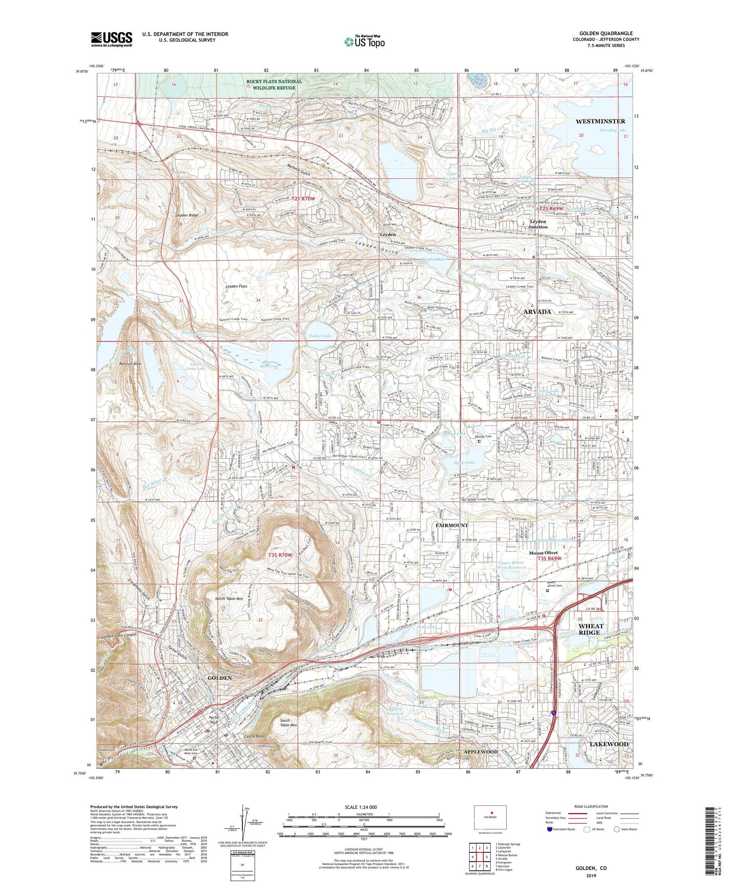
2022 topographic map quadrangle Golden in the state of Colorado. Scale: 1:24000. Based on the newly updated USGS 7.5' US Topo map series, this map is in the following counties: Jefferson. The map contains contour data, water features, and other items you are used to seeing on USGS maps, but also has updated roads and other features. This is the next generation of topographic maps. Printed on high-quality waterproof paper with UV fade-resistant inks.
Quads adjacent to this one:
West: Ralston Buttes
Northwest: Eldorado Springs
North: Louisville
Northeast: Lafayette
East: Arvada
Southeast: Fort Logan
South: Morrison
Southwest: Evergreen
This map covers the same area as the classic USGS quad with code o39105g2.
Contains the following named places: Alderson Hall, Alice Sweet Thomas Park, Alkire Estates, Apple Meadows, Applemeadows Park, Applewood, Applewood Census Designated Place, Applewood Golf Course, Applewood Village, Applewood Village Shopping Center, Arapahoe Park, Arthur Lakes Library, Arvada Church of Christ, Arvada Filtration Plant, Arvada Fire Protection District Station 6, Arvada Fire Protection District Station 7, Arvada Fire Protection District Station 8, Arvada Fire Protection District Training Center, Arvada West High School, Arvada West Town Center Shopping Center, Barbara Gulch, Berthoud Hall, Blunn Dam, Blunn Reservoir, Bradford Residence Hall, Brannan Pit Number Twenty-six, Brayfield Open Space, Bridgeside Park, Broad Dam, Broad Lake, Brooks Field, Cameo Estates, Candlelight, Castle Rock, Cedar Creek, Cedar Gulch, Centennial Cone Mine, Chauvenet Hall, Chester - Portsmouth Park, Chimney Gulch, Christ Community Covenant Church, Church Lake, Churches Dam, Churchs Pit, City of Arvada, City of Arvada Service Center, Clear Creek Canyon, Colorado Actors Company and Theater School, Colorado Railroad Museum, Colorado School of Mines, Community In Christ Lutheran Church, Compass Montessori Secondary School, Coolbaugh Hall, Coors Technology Center, Country View Estates, Cressman Gulch Park, Cressmans Gulch, Crestmont Heights, Croke Canal, Cross Creek, Danny Kendricks Park, Davis Lane Park, Dog Pound Pit, Downtown Golden Post Office, Drake Middle School, Duke Lake, Duke Lake Dam, Eldorado Estates, Engineering Hall, Enterprise Grange, Excel Academy, Fairmount Census Designated Place, Fairmount Elementary School, Fairmount Fire - Rescue Station 2, Fairmount Fire Rescue District Office Station 31, Fairmount Fire Rescue Station 33, Fairmount Reservoir, Faith Christian Academy Elementary School, Faith Christian Academy Middle School, Farmers Highline Canal, Foothills Art Center, Fremont Elementary School, Golden, Golden Branch Jefferson County Public Library, Golden City Hall, Golden Fire Department Station 21, Golden Fire Inspector Office, Golden Gate Canyon, Golden Pit, Golden Police Department, Green Center, Guggenheim Hall, Harry S Truman Park, Hidden Lake Dam, Hidden Lake Reservoir, Hill Hall, Hillcrest Baptist Church, Hopewell School, Hyatt Lake, Indian Gulch, Indiana Street Open Space, Kelly Dam, Kelly Lake, Kullerstrand Elementary School, Ladwig Properties Mine, Lakewood Christian School, Last Chance Number 1 Dam, Lee Stewart and Eskin Ditch, Lewis Meadows Park, Leyden, Leyden Creek Park, Leyden Dam, Leyden Flats, Leyden Gulch, Leyden Junction, Leyden Lake, Leyden Lignite Number Three Mine, Leyden Number One Mine, Leyden Number Three Mine, Leyden Number Two Mine, Leyden Ridge, Lions Park, Long Lake Ditch, Loveland Mine, Lower Long Lake, Lower Long Lake Dam, Lower Twin Lake, Maple Grove Dam, Maple Grove Elementary School, Maple Grove Park, Maple Grove Reservoir, Maple Valley Park, Meadow Lake, Meadow Wood Farms, Meadowbrook Village Trail Park, Meadowlake Park, Meiklejohn Elementary School, Mesa Heights, Mesa Meadows Park, Meyer Hall, Michael Northey Park, Mitchell Elementary School, Montessori School of Golden, Moon Gulch, Moon Gulch Park, Morgan Residence Hall, Mount Olivet, Mount Olivet Cemetery, New Loveland Mine, North Table Mountain, North Table Mountain Infiltration Plant, North Table Mountain Mine, Northeast Jefferson Division, Northwood Acres, Old Leyden Coal Mine, Parfel Park, Plastic, Prospect Lake, Prospect Park, Quaker Acres, Quaker Acres Park, Rainbow Ridge, Rainbow Ridge Park, Ralston Cemetery, Ralston Church, Ralston Dam, Ralston Dike, Ralston Estates, Ralston Pit, Ralston Reservoir, Ralston Valley, Ralston Valley High School, Ralston Valley Park, Ramstetter Creek, Ramstetter Reservoir, Reno Ditch, Reno Juchem Ditch, Rocky, Rocky Flats Dam, Rocky Flats Lake, Rocky Mountain Aggregates Mine, Rocky Mountain Ditch, Rocky Mountain Research Incorporated Mine, Rolling Dam, Rolling Hills Country Club, Rolling Reservoir, Shadow Mountain Park, Sherwood Farms, Smart Ditch, South Table Mountain, South Table Mountain Park, Spicer Clay Mine, Spring Mesa, Standley Lake Park, State Clay Mine, Steinhauer Field House, Stober Elementary School, Stott Elementary School, Stratton Hall, Supreme Estates, Swadley Ditch, Table Mountain Park, Tabor Lake, The Manning School of Academics and Arts, Thomas Residence Hall, Tindal Mine, Tony Grampas Memorial Sports Complex, Tucker Gulch, Tucker Lake, Tucker Lake Dam, Tucker Lake Open Space Park, Upper Long Lake, Upper Long Lake Dam, Upper Mount Olivet Dam, Upper Mount Olivet Reservoir, Upper Twin Lake, Van Arsdale Elementary School, Van Bibber Park, Vanderhoof Elementary School, Vanover Park, Village of Five Parks, Volk Gymnasium, Wannamaker Ditch, Welch Ditch, West Lake, West Lake Pit, West Woods Elementary School, White Ash Mine, White Ash Mine Cemetery, Woman Creek, Yankee Doodle Park, Youngfield Plaza Shopping Center, Youth Memorial Sports Complex, ZIP Codes: 80005, 80007


