MyTopo
Morrison Colorado US Topo Map
Couldn't load pickup availability
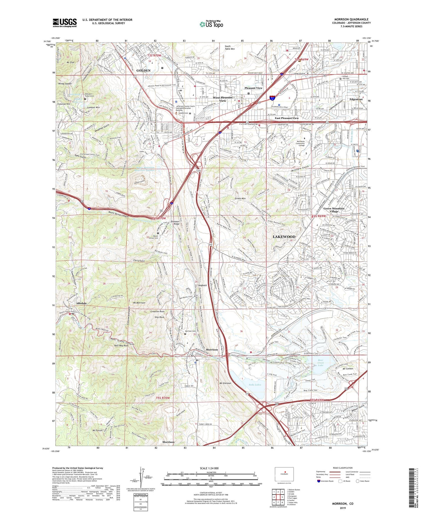
2022 topographic map quadrangle Morrison in the state of Colorado. Scale: 1:24000. Based on the newly updated USGS 7.5' US Topo map series, this map is in the following counties: Jefferson. The map contains contour data, water features, and other items you are used to seeing on USGS maps, but also has updated roads and other features. This is the next generation of topographic maps. Printed on high-quality waterproof paper with UV fade-resistant inks.
Quads adjacent to this one:
West: Evergreen
Northwest: Ralston Buttes
North: Golden
Northeast: Arvada
East: Fort Logan
Southeast: Littleton
South: Indian Hills
Southwest: Conifer
This map covers the same area as the classic USGS quad with code o39105f2.
Contains the following named places: Agricultural Ditch, Allied Dirt Division Green Mountain Pit, Apex Gulch, Apex Park, Applewood Glen, Applewood Grove, Applewood Grove Shopping Center, Applewood Park, Bandimere Pit, Bandimere Speedway, Bear Creek Canyon, Bear Creek Dam, Bear Creek Golf Club, Bear Creek Lake, Bear Creek Lake Park, Beaver Brook Number 3 Dam, Beech Park, Bell Middle School, Benerly Heights Park, Blue Star Memorial Park, Brannon Pit Number Seventeen, Brown Building, Buffalo Bill Memorial Museum, Carbon Mountain Pit, Cherry Gulch, Chieftain Mine, City of Golden, College West Estates, Colorado Law Enforcement Training Academy, Colorado Mills, Colorado Mills Mall Shopping Center, Colorado School of Mines Tunnel, Colorow Hill, Colorow Mountain Park, Connections Learning Center Earle Johnson School, Continental Rhenium Corporation Mine, Coors Sand and Gravel Pit, Cottage School Number 1, Cottonwood Gulch, Coyote Gulch Park, Creation Rock, Crestview Villa, Daniels Garden, Daniels School, Deadman Gulch, Denver Mountain Parks Emergency Headquarters, Denver University Research Institute, Denver West Surgery Center, Devils Gulch, Devinney Elementary School, Devinny Cottage School, Dinosaur Ridge, Doughty Pit, Dry Creek Pit, Dunston Middle School, East Pleasant View Census Designated Place, Edgemont, Estates Park, Fairgrounds Gulch, Foothill Mine, Foothills Elementary School, Foothills Mine, Foothills Park, Foothills Shopping Center, Forsberg Park, Fossil Trace Golf Club, Fox Hollow at Lakewood Golf Course, Gary McDonnell Park, Glennon Heights Cottage School Number 2, Golden Cemetery, Golden Heights, Golden Heights Park, Golden Hill Cemetery, Golden Municipal Recreation Park, Golden Post Office, Golden Quarry, Golden Reservoir, Grapevine Mine, Green Mountain, Green Mountain Clay Pit, Green Mountain Elementary School, Green Mountain High School, Green Mountain Park, Green Mountain Plaza Shopping Center, Green Mountain Recreation Center, Green Mountain Village, Green Mountain Village Park, Half Way Rock, Hayden Green Mountain Park, Heberison Pit, Heritage Dells, Heritage Dells Park, Heritage Square, Hogback, Hogback Park, Hutchinson Elementary School, Hutchinson Park, Idledale, Idledale Census Designated Place, Idledale Post Office, Iron Spring Park, Jackson Gulch, Jefferson County Fairgrounds, KAZY-FM (Denver), KBDI-TV (Broomfield), KBPI-FM (Denver), KCNC-TV (Denver), KDVR-TV (Denver), Kendallvue Elementary School, Kenneys Creek, KHOW-FM (Denver), KMGH-TV (Denver), KOAQ-FM (Denver), KOSI-FM (Denver), KRXY-FM (Lakewood), KSHP-TV (Denver), KTVD-TV (Denver), KTVJ-TV (Boulder), KUSA-TV (Denver), KVOD-FM (Denver), KWGN-TV (Denver), KXLT-FM (Denver), Kyffin Elementary School, Landsay Pit, Lariat Spring, Leyden Pit, Linda Number One Mine, Linda Number Two Mine, Little Park, Lochwood Park, Lookout Center Parking Lot Heliport, Lookout Center Rooftop Heliport, Lookout Mountain, Lookout Mountain Nature Center, Lookout Mountain Park, Lookout Mountain Youth Services Center, Loveland Trail Park, Magic Mountain Number 1 Dam, Magic Mountain Reservoir Number 1, Mann Ranch Mine, Mannon Pit, Market Square Shopping Center, Matthews/Winters Park, McIntyre Pit, Morrison, Morrison Cemetery, Morrison City Hall, Morrison Post Office, Morrison Quarry, Morton Heliport, Mother Cabrini Orphanage, Mother Cabrini Shrine, Mount Carbon, Mount Falcon, Mount Falcon Park, Mount Glennon, Mount Glennon Park, Mount Morrison, Mount Morrison Heliport, Mount Vernon Canyon, Mount Vernon Cemetery, Mount Vernon Creek, Mount Zion, Mountain View Estates, Mountainside Park, North Chieftain Pit, North Golden Pit, North Rock Quarry, OrthoColorado Hospital, Pallaro Lease Mine, Panorama Heights, Peterson Park, Pit Number Twenty-two, Pleasant View, Pleasant View Elementary School, Ravines Open Space, Red Rocks Amphitheater, Red Rocks Community College, Red Rocks Elementary School, Red Rocks Park, Rockwell Pit, Rocky Mountain Deaf School, Rooney Gulch, Rooney Ranch Elementary School, Saint Anthony Hospital and Medical Center, Sawmill Gulch, Shepherd Mine, Shingle Creek, Ship Rock, Sixth Avenue West Park, Soda East Reservoir Number 2, Soda Lake Number 1 Dam, Soda Lake Number 2 Dam, Soda Lakes, Soda Lakes Clubhouse, Soda Lakes Marina, Soda West Reservoir Number 1, Solar Energy Research Institute, South Chieftain Pit, South Ridge Park, South Simms Park, Spring Hill, Strain Gulch, Strainland Pit, Tanglewood Sports Park, Teagarden Pit, Tincup Mine, Town of Morrison, Trappers Glen Park, Turkey Creek, Union Ridge Park, Union Square Park, Union Square Shopping Area, Ute Trail Park, Vernon Gardens, Ward Canal, Warren Occupational Technical Center, Warrior Canal, Weaver Creek Park, Weaver Gulch, Weaver Hollow Park, Welchester Elementary School, Welchester Tree Grant Park, West Pleasant View Census Designated Place, Wilbur Rogers Center, William F Cody Grave, Windy Saddle, Windy Saddle Park, Wright Lease Mine, Wright Park, ZIP Codes: 80228, 80401, 80419, 80453, 80454