MyTopo
Grand Junction Colorado US Topo Map
Couldn't load pickup availability
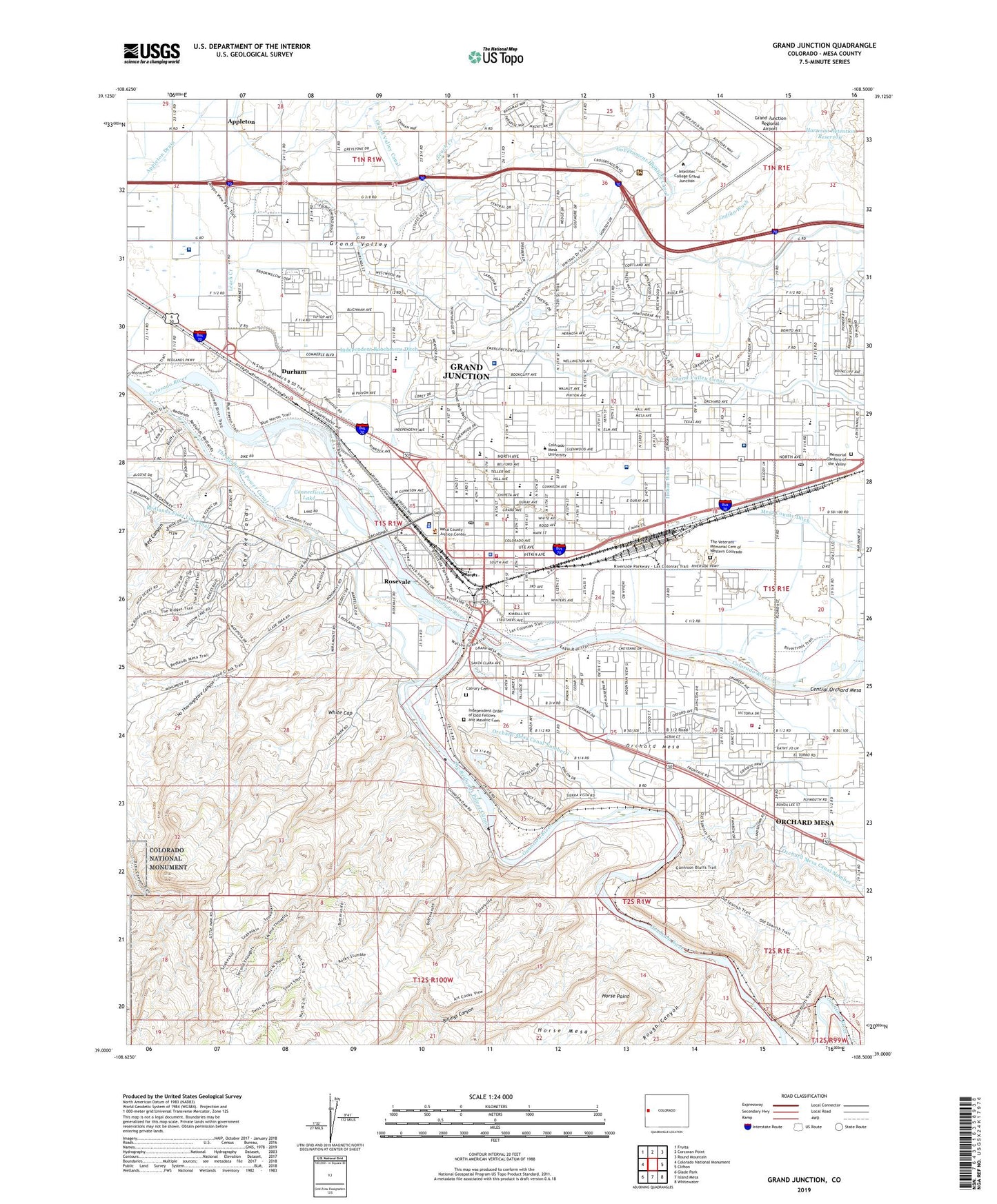
2022 topographic map quadrangle Grand Junction in the state of Colorado. Scale: 1:24000. Based on the newly updated USGS 7.5' US Topo map series, this map is in the following counties: Mesa. The map contains contour data, water features, and other items you are used to seeing on USGS maps, but also has updated roads and other features. This is the next generation of topographic maps. Printed on high-quality waterproof paper with UV fade-resistant inks.
Quads adjacent to this one:
West: Colorado National Monument
Northwest: Fruita
North: Corcoran Point
Northeast: Round Mountain
East: Clifton
Southeast: Whitewater
South: Island Mesa
Southwest: Glade Park
This map covers the same area as the classic USGS quad with code o39108a5.
Contains the following named places: Abbot Pit, Amax Uranium Mine, Appleton, Appleton Drain, Billings Canyon, BLM Fire Center Heliport, Bookcliff Country Club, Burk Pit, Calvary Cemetery, C-G-26 Mine, Church of the Brethren, City of Grand Junction, Colorado Copper Properties Mine, Community Hospital, Connecticut Lake, Durham, Eastgate Center, Egger Pit 501, Emerson School, Fireside Enterprises Quarry, Fruitvale Post Office, Gardner Lake Dam, Gardner Lake Reservoir, Grand Junction, Grand Junction Division, Grand Junction Fire Department Station 1, Grand Junction Fire Department Station 2, Grand Junction Fire Department Station 3, Grand Junction Fire Department Station 4, Grand Junction Police Department, Grand Junction Post Office, Grand Junction Regional Airport, Grand Speedway, Grand Valley Canal, Gunnison River, Hartman Retention Dam, Hartman Retention Reservoir, Hawthorne School, Herron and Strong Pit, Himes Drilling Mine, Horse Point, Independent Order of Odd Fellows and Masonic Cemetery, Indian Wash, KCIC-FM (Grand Junction), KEXO-AM (Grand Junction), KJOL-FM (Grand Junction), KJYE-FM (Grand Junction), KMSA-FM (Grand Junction), KQIL-AM (Grand Junction), KQIX-FM (Grand Junction), KREX-TV (Grand Junction), Ladder Creek, Leach Creek, Lincoln Orchard Mesa Elementary School, Lincoln Park, Lowell School, Mantey Heights Rehabilitation and Care Center, Melrose Park, Memorial Gardens of the Valley, Mesa College, Mesa County Detention Center, Mesa County Ditch, Mesa County Sheriff's Office, Mesa Mall, Mesa View Church, Mesa Village Shopping Center, Mountain Bell Heliport, New Emerson School at Columbus, Nisley Elementary School, No Thoroughfare Canyon, Orchard Avenue Elementary School, Orchard Mesa, Orchard Mesa Census Designated Place, Pioneer Village Shopping Center, Pomona Elementary School, Red Canyon, Redlands Dam, Rosevale, Rough Canyon, Saint Josephs School, Saint Mary's CareFlight Medical Transport, Saint Mary's Hospital and Medical Center, Saint Marys Hospital and Medical Center Heliport, Saint Nicholas Church, Sherwood Park, Solarus Square Shopping Center, Teller Arms Center, The Redlands, The Redlands Power Canal, The Veterans Memorial Cemetery of Western Colorado, Tope Elementary School, United Sand and Gravel Pit, Unity Church, Uranium Downs, VA Western Colorado Health Care System Hospital, Washington Park, West Springs Hospital, White Cap, Whitman School, ZIP Codes: 81501, 81506