MyTopo
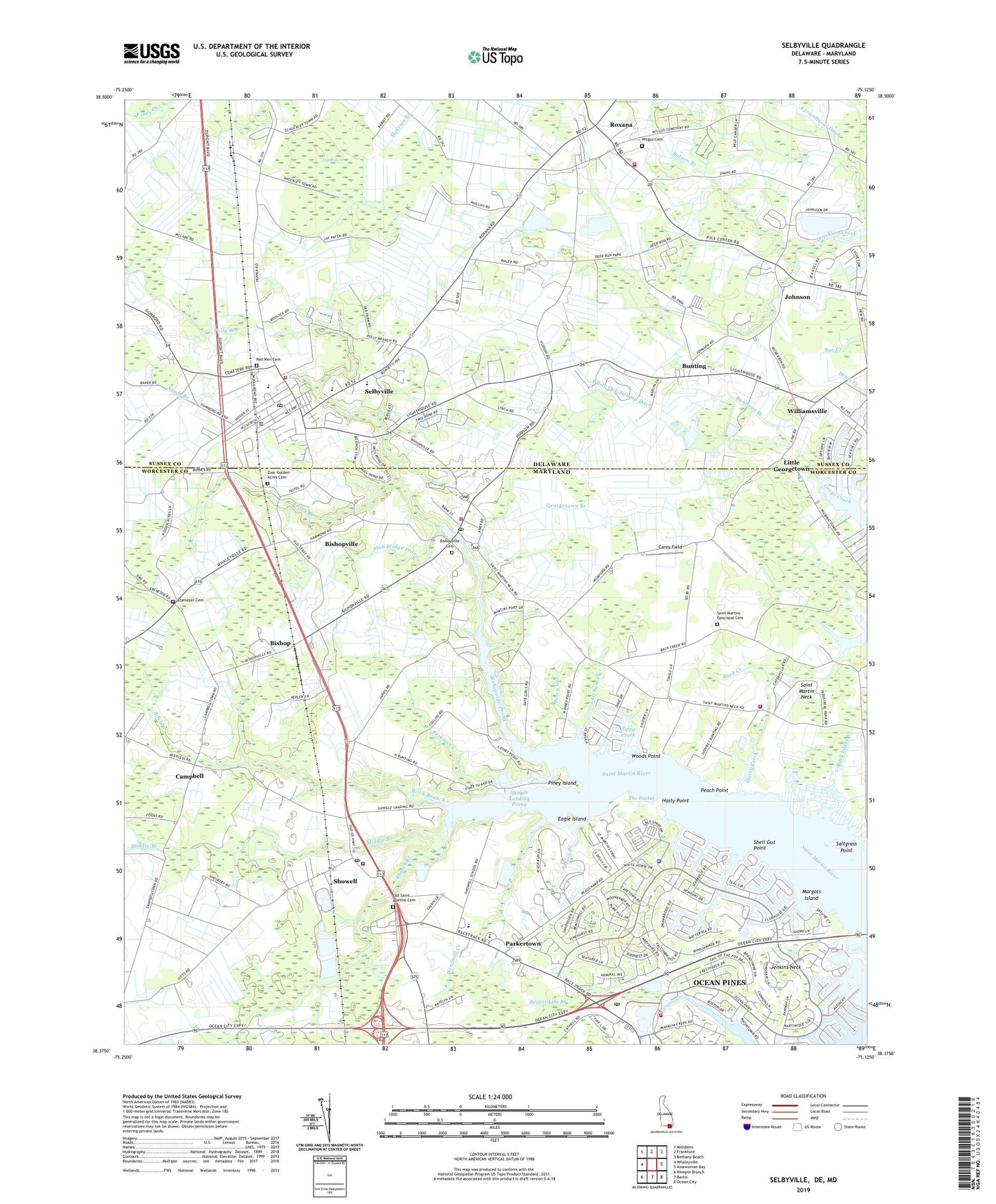
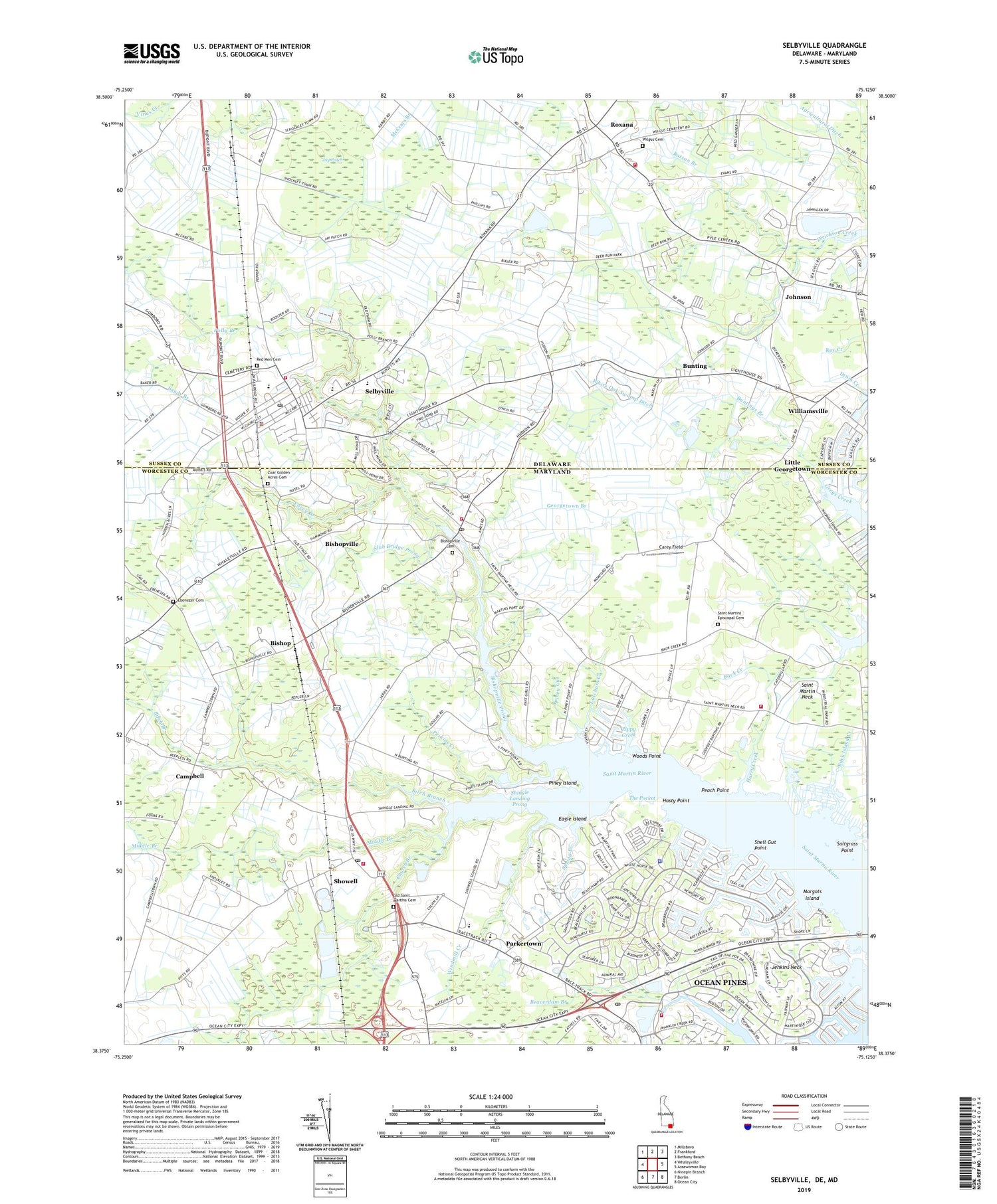
Selbyville Delaware US Topo Map
Couldn't load pickup availability
2023 topographic map quadrangle Selbyville in the states of Maryland, Delaware. Scale: 1:24000. Based on the newly updated USGS 7.5' US Topo map series, this map is in the following counties: Sussex, Worcester. The map contains contour data, water features, and other items you are used to seeing on USGS maps, but also has updated roads and other features. This is the next generation of topographic maps. Printed on high-quality waterproof paper with UV fade-resistant inks.
Quads adjacent to this one:
West: Whaleyville
Northwest: Millsboro
North: Frankford
Northeast: Bethany Beach
East: Assawoman Bay
Southeast: Ocean City
South: Berlin
Southwest: Ninepin Branch
Contains the following named places: Agricultural Ditch, Assembly of God Church, Bainbridge, Batson Branch, Bay Colony, Bay View Estates, Beachwood, Bearhole Ditch, Beaverdam Branch, Birch Branch, Bishop, Bishop Commercial Center, Bishopville, Bishopville Cemetery, Bishopville Census Designated Place, Bishopville Park, Bishopville Post Office, Bishopville Prong, Bishopville Volunteer Fire Department - Station 900, Bishopville Volunteer Fire Department Station 2, Bramblewood, Buck Island Creek, Buck Island Pond, Bunting, Buntings Branch, Calvary Pentecostal Church, Campbell, Cape Pleasant, Carey Branch, Carey Field, Church Branch, Community United Methodist Church, Curtis Church, District 5 Ocean Pines, District 6 Northern, Douglynn Farms, Eagle Island, Ebenezer Cemetery, Ebenezer Church, Fenwick Estates, Georgetown Branch, Harry Creek, Hasty Point, Haystack Pond, Hen and Chickens Island, Holiday Harbor, Holiday Manor, Hudson Crossroads, Huntington, Indian River School District, Jay Patch, Jenkins Neck, Johnson, Lantern Lane Mobile Villa, Latchum Creek, Little Georgetown, Louis Heights, Manklin Meadows, Manklin Moorings, Margots Island, Middle Branch, Mumfords Landing, Nantucket, Newport, North Ocean Pines, Ocean Pines, Ocean Pines Census Designated Place, Ocean Pines Country Club, Ocean Pines Police Department, Ocean Pines Post Office, Ocean Pines Volunteer Fire Department - Station 1100, Ocean Pines Volunteer Fire Department North Station, Ocean Pines Yacht Club, Old Saint Martins Cemetery, Old Saint Martins Church, Parkertown, Peach Point, Pepper Ridge Mobile Home Park, Perkins Creek, Phillip C Showell Elementary School, Pine Shore Golf Course, Pinehurst, Piney Gut, Piney Island, Piney Point, Pintail Isle, Polly Branch, Red Men Cemetery, Roxana, Roxana Methodist Church, Roxana Volunteer Fire Company Station 1 Headquarters, Roxana Wesleyan Church, Saint John African Methodist Episcopal Church, Saint Martins by the Bay, Saint Martins Episcopal Cemetery, Saint Matthews Church, Saltgrass Point, Sandy Branch, School Number 1, School Number 3, Seabright, Selbyville, Selbyville Industrial Park, Selbyville Middle School, Selbyville Police Department, Selbyville Post Office, Selbyville Public Library, Selbyville Town Hall, Selbyville Volunteer Fire Company, Selbyville Wastewater Treatment Facility, Shell Gut Point, Shingle Landing, Shingle Landing Prong, Showell, Showell Elementary School, Showell Park, Showell Post Office, Showell Station, Showell United Methodist Church, Showell Volunteer Fire Department - Station 800, Slab Bridge Prong, Smithfield Acres, Somerset, South Ocean Pines, Southern Delaware School of the Arts, Spring Branch, Spring Brook Forest, Tanglewood, Teal Bay, The Pocket, Thessalonia Baptist Church, Tidewater School By the Sea, Todd Industrial Park, Town of Selbyville, Warrington Field Airport, WETT-AM (Ocean City), White Horse Camp Ground, White Oak Swamp Ditch, Wilgus Cemetery, Williamsville, Wilson Church, Windmill Creek, Woods Point, Zion Church, Zippy Creek, Zoar Golden Acres Cemetery, Zoar Methodist Church, ZIP Codes: 19975, 21813, 21862