MyTopo
Cooper City Florida US Topo Map
Couldn't load pickup availability
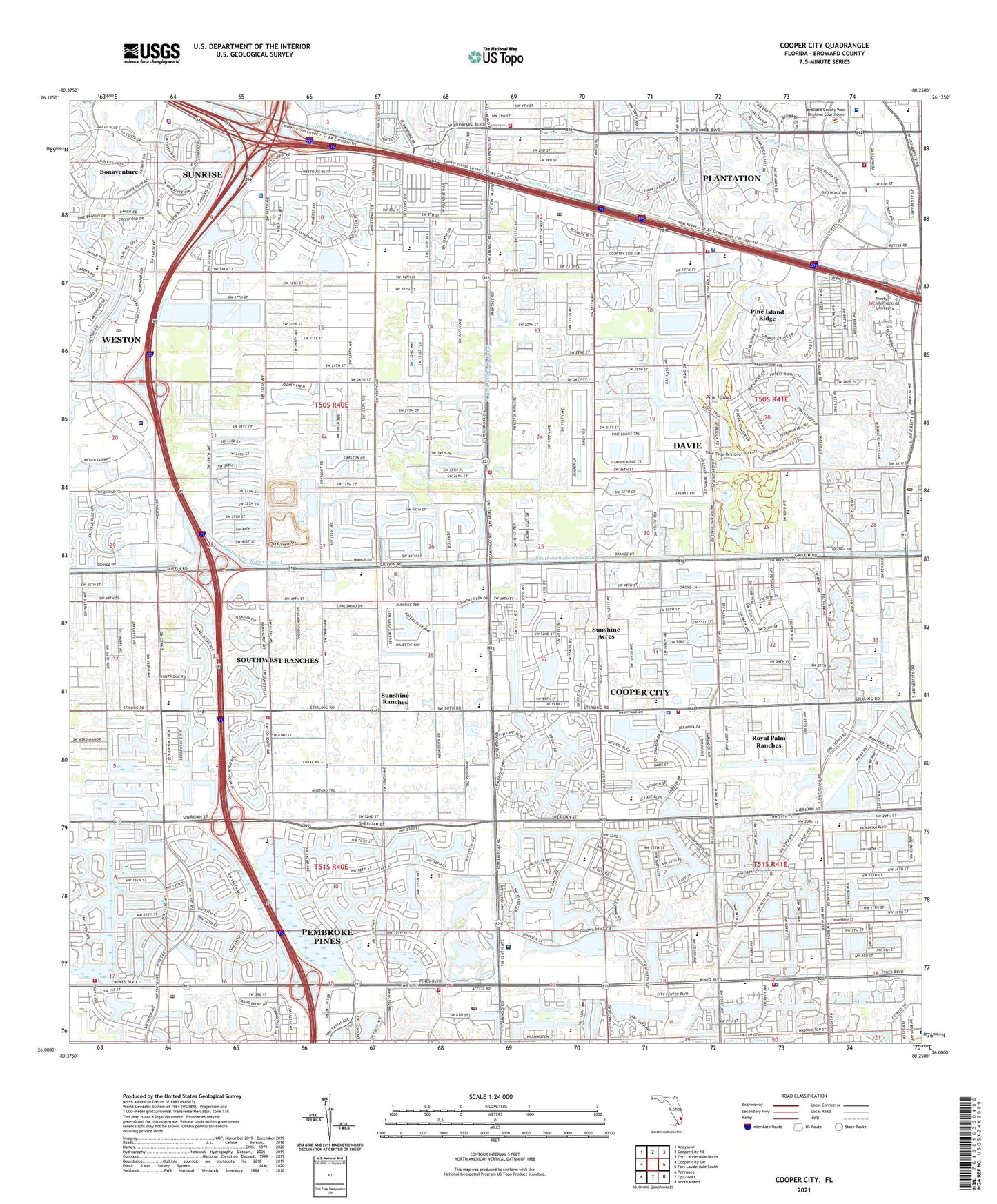
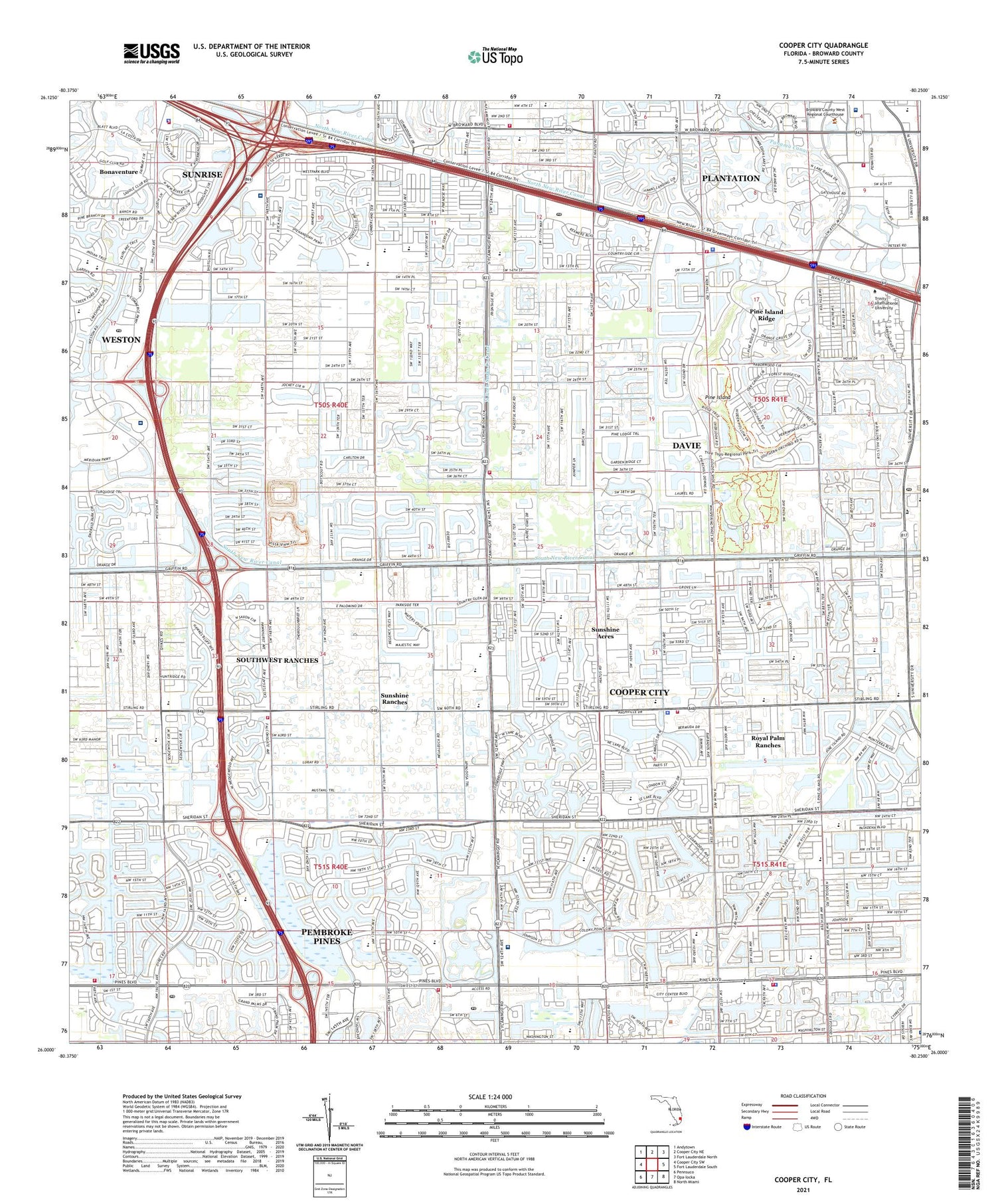
2024 topographic map quadrangle Cooper City in the state of Florida. Scale: 1:24000. Based on the newly updated USGS 7.5' US Topo map series, this map is in the following counties: Broward. The map contains contour data, water features, and other items you are used to seeing on USGS maps, but also has updated roads and other features. This is the next generation of topographic maps. Printed on high-quality waterproof paper with UV fade-resistant inks.
Quads adjacent to this one:
West: Cooper City SW
Northwest: Andytown
North: Cooper City NE
Northeast: Fort Lauderdale North
East: Fort Lauderdale South
Southeast: North Miami
South: Opa-locka
Southwest: Pennsuco
This map covers the same area as the classic USGS quad with code o26080a3.
Contains the following named places: Academy Senior High School, Alexander Nininger State Veterans Nursing Home, All American Memorial Church School, Alpha Day School, American Heritage School, American Intercontinental University Information Resources Center, Broward Christian School, Broward County Sheriffs Office Department of Fire Rescue and Emergency Services Station 28, Broward County Sheriff's Office District 16 Cooper City, Broward Mall, Camp Seminole, Charles W Flanagan High School, Cheron Village Mobile Home Park, City of Cooper City, City of Pembroke Pines, Cleveland Clinic Florida, Cleveland Clinic Florida Hospital Heliport, Cocoa Beach Country Club, Collier's Reserve Country Club, Colonial Country Club, Colony West Country Club, Continuum Care Services, Cooper City, Cooper City Elementary School, Cooper City Fire Station, Cooper City High School, Cooper City Plaza, Cooper City Plaza Shopping Center, Cooper City Utility Department, Country Isles Elementary School, Countryside Shopping Center, Covenant Village Care Center, Davie Country Stores Shopping Center, Davie Division, Davie Fire Rescue Station 65, Davie Fire Rescue Station 68, Davie Fire Rescue Station 91, Davie Fire Station, Davie Police Department, Davie Post Office, Davie-Cooper City Branch Library, East Pine Ridge Mobile Home Park, Elaine Gordon Treatment Center, Embassy Creek Elementary School, Faith Child Development Center, Fashion Mall at Plantation, Fire Station Number 69, Fire Station Number 89, Fire Station Number 99, Flamingo Elementary School, Flamingo Pines Square Shopping Center, Flamingo Post Office, Flamingo Road County Park, Flanagan High School, Florida Highway Patrol Troop L Davie Station, Fox Trail Elementary School, Green Meadow Census Designated Place, Hawkes Bluff Elementary School, Hilltop Montessori School, Hollywood Free Will Baptist Day School, Hollywood Memorial Walk In Medical Center, Home Center, Humana Hospital Bennett, Indian Ridge Middle School, Indian Trace Square Shopping Center, Ivanhoe Estates Census Designated Place, Jacaranda School, Kings Manor Estates Mobile Home Park, Lakeside Elementary School, Market Place Fashion Mall, Meadowbrook Golf Club, Melalevca Isles, Melbourne Municipal Golf Course, Memorial Hospital West, Memorial Manor, Miami Speedway Park, North Fork Snake Creek Canal, Palm Cove Elementary School, Palm Haven Mobile Home Park, Palm Johnson Plaza Shopping Center, Panama Canal, Panther Run Elementary School, Paradise Village Mobile Home Park, Park City West Mobile Home Park, Pasadena Elementary School, Pasadena Lakes Elementary School, Pembroke Commons Shopping Center, Pembroke Lakes Academy, Pembroke Lakes Elementary School, Pembroke Lakes Golf Course, Pembroke Lakes Mall Shopping Center, Pembroke Pines Branch-Walter C Young Resource Center, Pembroke Pines Fire and Rescue Station 69, Pembroke Pines Fire and Rescue Station 89, Pembroke Pines Fire and Rescue Station 99, Pembroke Pines Plaza West, Pembroke Pines Police Department, Pine Island, Pine Island Ridge, Pine Island Ridge County Park, Pine Lakes City Hall, Pine Lakes Elementary School, Pines Lakes Elementary School, Pines Middle School, Pioneer Middle School, Plantation Community Plaza, Plantation Fire Department Station 62, Plantation Fire Department Station 76, Plaza Limited, Randal Square Shopping Center, Rexmere Village Mobile Home Park, Ridge Plaza, Royal Palm Ranches, Royal Palm Ranches Census Designated Place, Saint David Catholic School, Saint Gregory School, Saint Johns County Golf Course, Saint Stephen Lutheran Church, Sarabande Golf Course, Seventh-Day Adventist Christian School, Shoppes of Cooper City, Shops at Broward, Silver Palms Elementary School, Silver Ridge Elementary School, Snake Creek Park, Southwest Ranches, Southwest Ranches Volunteer Fire Rescue, Southwest Regional Library, Sunrise Fire Rescue Station 83, Sunrise Police Department Westside Substation, Sunshine Acres, Sunshine Acres Census Designated Place, Sunshine City Mobile Home Park, Sunshine Ranches, Sunshine Ranches Census Designated Place, Sunshine Village Mobile Home Park, Temple Koi Ami Preschool, Town and Country Center, Town of Davie, Towngate Elementary School, Tree Tops Park, University Mall Shopping Center, University Market Place Shopping Center, W C Young Elementary School, Walter C Young Middle School, Walter C Young Resource Center, West Broward Care Center, West Pines Post Office, West Regional Library, Western High School, Western High School 10th Grade Annex, Western Hills Estates Mobile Home Park, Weston City Hall, Weston Post Office, Westside New Post Office, Westside Regional Medical Center, Wilderness Country Club, WLQY-AM (Hollywood), ZIP Codes: 33026, 33028, 33324, 33325, 33326, 33328, 33330, 33331