
MyTopo
Estero Florida US Topo Map
Couldn't load pickup availability
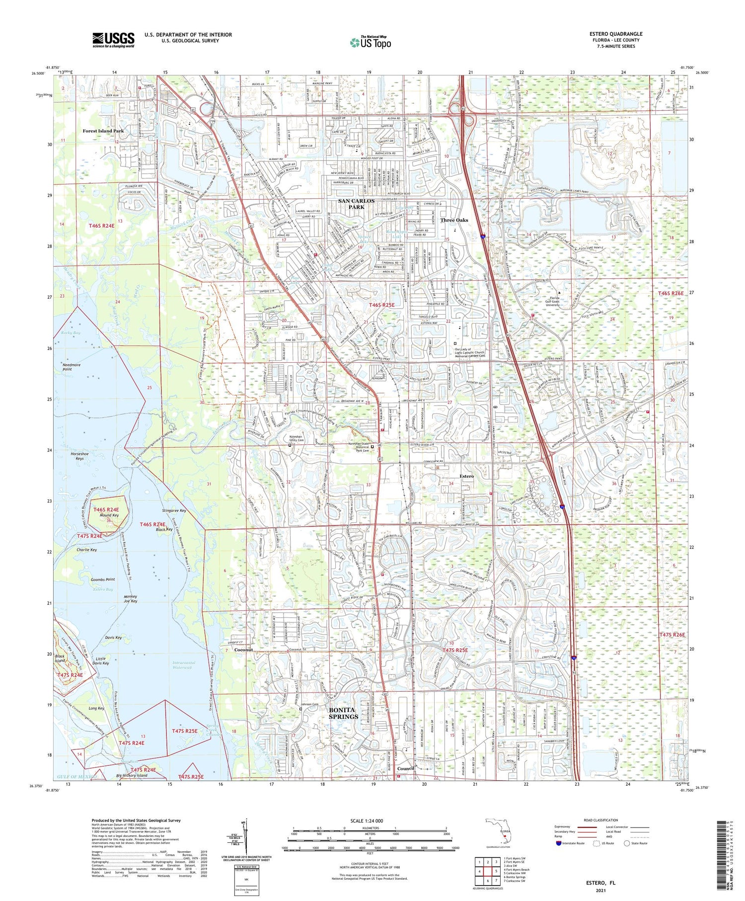
2025 topographic map quadrangle Estero in the state of Florida. Scale: 1:24000. Based on the newly updated USGS 7.5' US Topo map series, this map is in the following counties: Lee. The map contains contour data, water features, and other items you are used to seeing on USGS maps, but also has updated roads and other features. This is the next generation of topographic maps. Printed on high-quality waterproof paper with UV fade-resistant inks.
Quads adjacent to this one:
West: Fort Myers Beach
Northwest: Fort Myers SW
North: Fort Myers SE
Northeast: Alva SW
East: Corkscrew NW
Southeast: Corkscrew SW
South: Bonita Springs
This map covers the same area as the classic USGS quad with code o26081d7.
Contains the following named places: Balsam Lake, Black Island, Black Key, Boca Delray Golf and Country Club, Boca Dunes Golf and Country Club, Boca Grove Plantation Golf Course, Bonita Springs Division, Bonita Springs Fire Control and Rescue District Station 3, Carl E Johnson County Park, Cedar Lake, Charlie Key, Coconut, Council, Cross Way Baptist Church, Davis Key, Deep Creek Golf Club, Deer Island Golf and Lake Club, Deer Run Country Club, Deercreek Country Club, Deerfield Country Club, El Dorado Acres, Emerald Dunes Golf Course, Errol Country Club, Estero, Estero Bay, Estero Bay Aquatic Preserve, Estero Census Designated Place, Estero Country Day School, Estero Fire Rescue Station 41 - The George Horne Station, Estero Fire Rescue Station 42 - The Coconut Point Station, Estero Fire Rescue Station 43 - The Three Oaks Station, Estero Fire Rescue Station 44 - The Stoneybrook Station, Estero Lookout Tower, Estero Post Office, Estero River, Estero United Methodist Church, Fairways East Golf Course, First Baptist Church of Estero, Florida Gulf Coast University Census Designated Place, Florida Gulf Coast University Police Department, Forest Island Park, Goombs Point, Halfway Creek, Hendry Creek, Horseshoe Keys, Johnson Cemetery, Koreshan State Historic Site, Koreshan Unity Cemetery, Lamb of God Church, Lee County Emergency Medical Services, Lee County Emergency Medical Services Station 13, Lee County Public Library System South County Regional Library, Lily Lake, Little Davis Key, Long Key, Miromar Lakes, Monkey Joe Key, Mound Key, Mound Key Archaeological State Park, Mud Creek, Mullock Creek, Needmore Point, New Pass, Park Alliance Church, Pine Lake, Rocky Bay, Rose Apple Lake, San Carlos Christian Church, San Carlos Park, San Carlos Park Census Designated Place, San Carlos Park Elementary School, San Carlos Park Fire Protection and Rescue Service District Station 51, San Carlos Park Fire Protection and Rescue Service District Station 52, San Carlos Park Fire Protection and Rescue Service District Station 53, Spring Creek, Spring Creek Channel, Spruce Lake, Stingaree Key, Stoneybrook Community Center, Sunny Grove Park Mobile Home Park, Tahiti Mobile Village, Three Oaks, Three Oaks Census Designated Place, Victory Christian Church, Village of Estero, Williams Road Helistop, WRXK-FM (Bonita Springs), ZIP Codes: 33965, 33967


