MyTopo
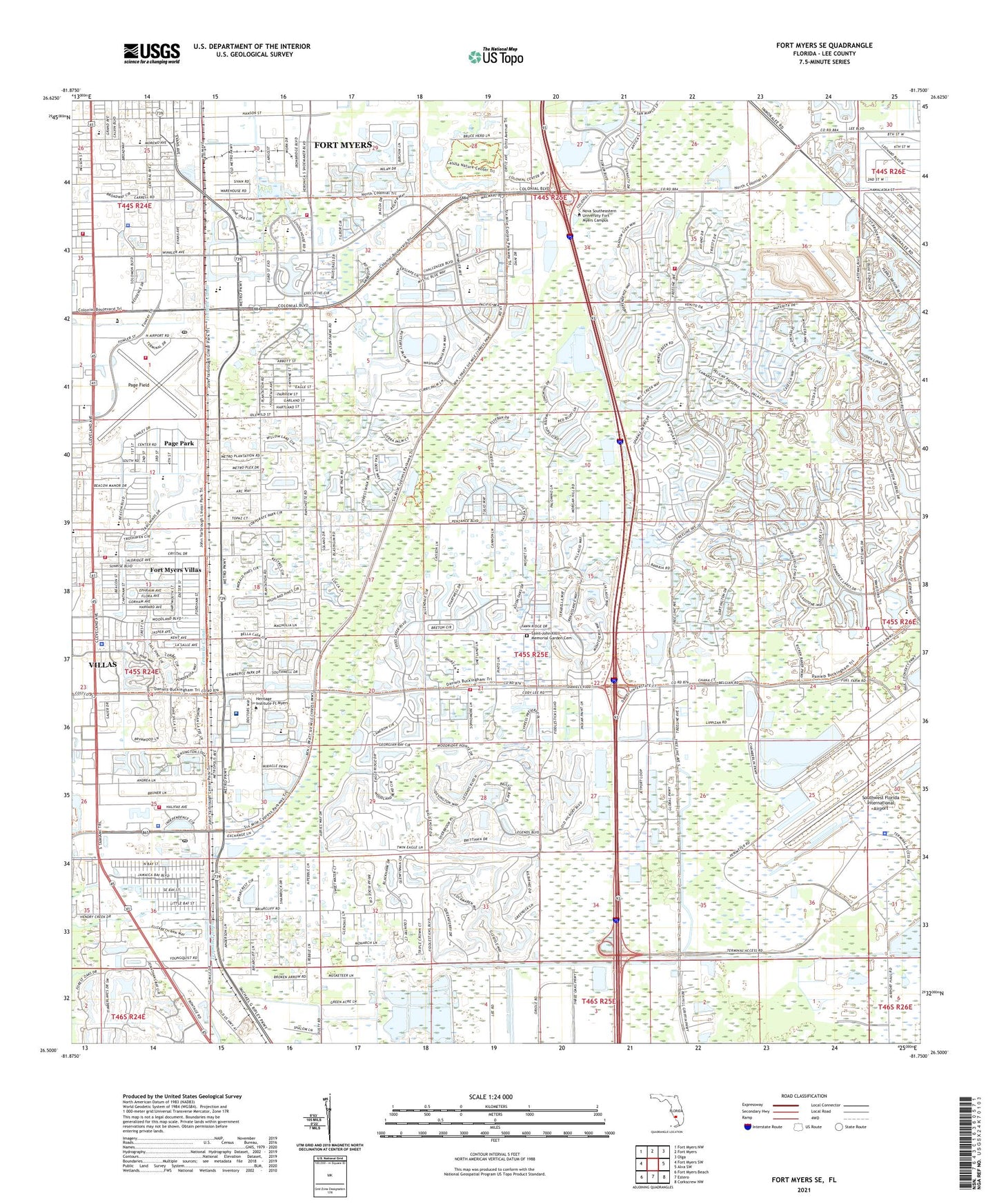
Fort Myers SE Florida US Topo Map
Couldn't load pickup availability
2024 topographic map quadrangle Fort Myers SE in the state of Florida. Scale: 1:24000. Based on the newly updated USGS 7.5' US Topo map series, this map is in the following counties: Lee. The map contains contour data, water features, and other items you are used to seeing on USGS maps, but also has updated roads and other features. This is the next generation of topographic maps. Printed on high-quality waterproof paper with UV fade-resistant inks.
Quads adjacent to this one:
West: Fort Myers SW
Northwest: Fort Myers NW
North: Fort Myers
Northeast: Olga
East: Alva SW
Southeast: Corkscrew NW
South: Estero
Southwest: Fort Myers Beach
This map covers the same area as the classic USGS quad with code o26081e7.
Contains the following named places: Blessed Pope John XXIII Catholic Church, Calusa Nature Center, Calusa Planetarium, Calvary Temple Assembly of God Church, Celebration Family Church, Christ Community Church of Fort Myers, Church of Living God, Church of the Nazarene, City of Fort Myers, Crown of Life Lutheran Church, Davis Trailer Park, Doral Golf Resort and Spa, Doral Park Silver Course, Dunes at Sandridge Golf Club, Eagle Creek Country Club, Eagle Lakes Golf Course, Eagle Point Golf Club, Edison Mall, Edison Mall Shopping Center, Evergreen Golf Club, Fairways Country Club, Federal Bureau of Investigation - Fort Myers Resident Agency, Florida Department of Law Enforcement Fort Myers Regional Operations Center, Florida Highway Patrol Troop F Fort Myers Station, Fort Myers Army Air Field, Fort Myers Christian School, Fort Myers Fire Department Station 3, Fort Myers Fire Department Station 5, Fort Myers Fire Department Station 6, Fort Myers Middle Academy, Fort Myers Police Department Winkler Safe Neighborhood Community Policing Center, Fort Myers Villas, Gateway, Gulf Coast Hospital, Gulf Coast Hospital Heliport, Hammond Stadium, Iglesia Emmanuel Baptist Church, Islamic Center of Southwest Florida, Jamaica Bay West Mobile Home Park, JetBlue Park, Korean - American Baptist Church of Fort Myers, Lee County Emergency Medical Services, Lee County Emergency Medical Services Station 1, Lee County Port Authority, Lee County Port Authority Page Field Fire Department, Lee County Port Authority Police Department, Lee County Port Authority Southwest Florida International Airport Police Department, Lee County Sheriff's Office Central District, Lee County Sheriff's Office Echo Central District, Lee County Sports Complex, Lee Wildlife Management Area, Miracle Mile Post Office, Montessori School of Fort Myers, Newlin Station, Page Field, Page Field Post Office, Page Mobile Home Village, Page Park, Page Park Census Designated Place, Park Meadow School and Child Care, Paul Laurence Dunbar Middle School, Rasmussen College - Fort Myers Campus, Redeemer Lutheran Church, Renaissance, Safe Harbor Community Church, Saint Michael Lutheran School, Saint Peters Community Church, Saint Phillip Christian Methodist Church, South Trail Fire and Rescue Station 61, South Trail Fire and Rescue Station 62, South Trail Fire and Rescue Station 63, South Trail Fire and Rescue Station 64, Southwest Florida International Airport, Southwest Florida Regional Medical Center, Southwest Florida Regional Medical Center Heliport, Tenmile Canal, The Church of Jesus Christ of Latter Day Saints, The Forest Country Club, Unitarian Universalist Church of Fort Myers, Villas, Villas Census Designated Place, Villas Elementary School, Wesley Memorial United Methodist Church, WINK-AM (Fort Myers), WMYR-AM (Fort Myers), Word of Life Church, WSRX-FM (Fort Myers), WSUV-FM (Fort Myers Villas), WZCR-FM (Fort Myers Beach), ZIP Codes: 33907, 33912, 33966