MyTopo
Fleming Island Florida US Topo Map
Couldn't load pickup availability
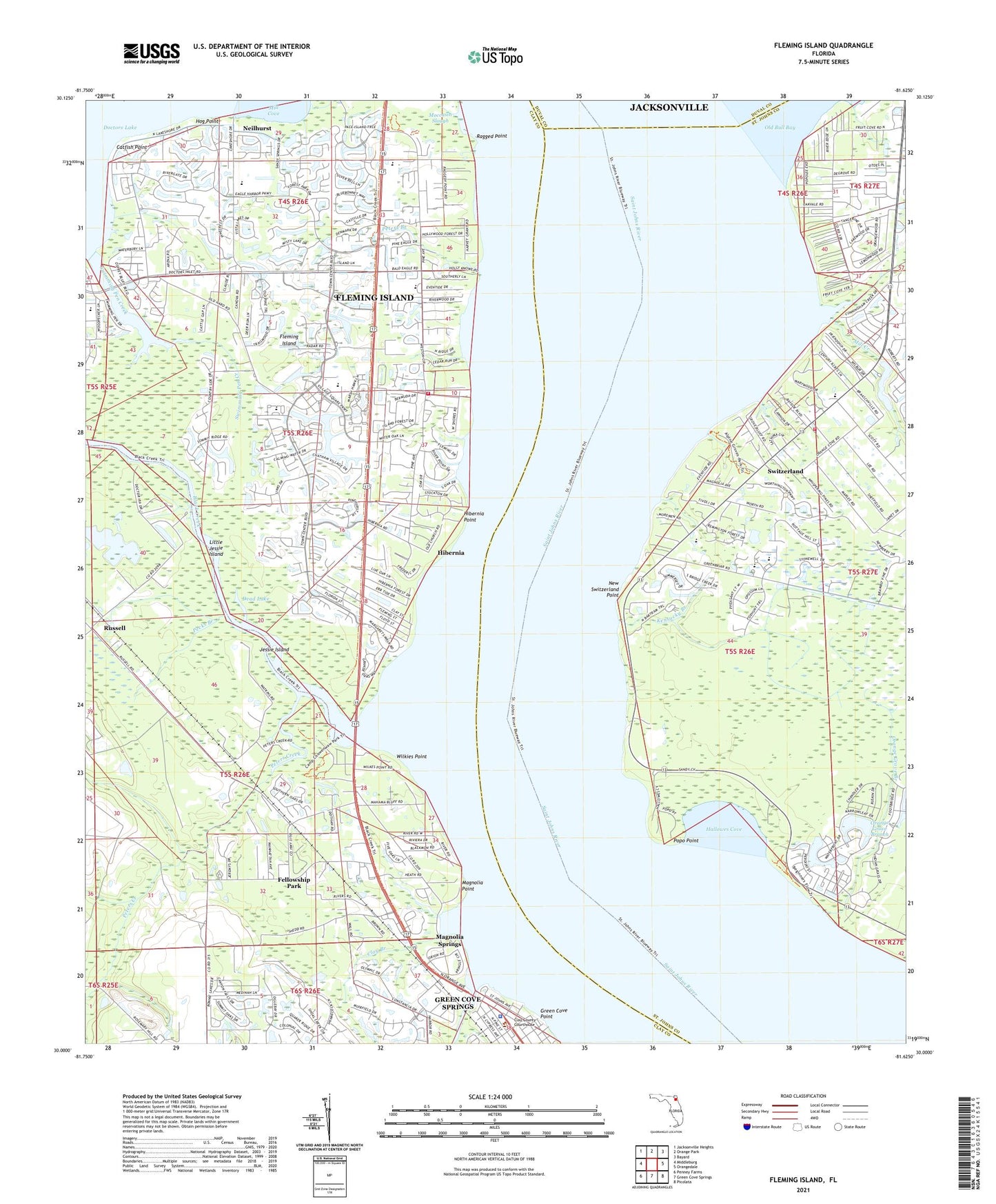
2024 topographic map quadrangle Fleming Island in the state of Florida. Scale: 1:24000. Based on the newly updated USGS 7.5' US Topo map series, this map is in the following counties: Clay, St. Johns, Duval. The map contains contour data, water features, and other items you are used to seeing on USGS maps, but also has updated roads and other features. This is the next generation of topographic maps. Printed on high-quality waterproof paper with UV fade-resistant inks.
Quads adjacent to this one:
West: Middleburg
Northwest: Jacksonville Heights
North: Orange Park
Northeast: Bayard
East: Orangedale
Southeast: Picolata
South: Green Cove Springs
Southwest: Penney Farms
This map covers the same area as the classic USGS quad with code o30081a6.
Contains the following named places: Amity Anchorage Marina, Amity Anchorage Mobile Home Park, Berean Church, Black Creek, Black Creek Tower, Camp Saint Johns, Catfish Point, Clay Branch, Clay County Fire Rescue Station 22 - Fleming Island, Clay County Fleming Island Regional Wastewater Treatment Facility, Clay County Fleming Oaks Wastewater Treatment Plant, Clay County Sheriff's Office, Crossroad Lutheran Church, Cunningham Creek, Dead Lake, Faith Wesleyan Church, Fellowship Park, Fleming Island, Fleming Island Baptist Church, Fleming Island Census Designated Place, Fleming Island Post Office, Fleming Island Presbyterian Church, Fleming Island Shopping Center, Foxfire Country Club, Fruit Cove, Fruit Cove Baptist Church, Governors Creek, Green Cove Point, Green Cove Springs Wastewater Treatment Plant, Hallowes Cove, Heritage Church, Hibernia, Hibernia Point, Hickory Slough, Hog Point, Jessie Island, Kentucky Branch, Knights Boat Ramp, Little Jessie Island, Magnolia Layne Shopping Center, Magnolia Point, Magnolia Springs, Magnolia Springs Post Office, Mainard Branch, Mill Creek, Mount Pleasant Church, Neilhurst, New Switzerland Point, Orange Avenue Church, Orange Grove Branch, Pecks Branch, Peters Branch, Peters Creek, Pine Lakes Golf Course, Pine Meadows Golf and Country Club, Popo Point, Ragged Point, Remington Park, Russell, Russell Landing, Saint Johns Chapel, Saint Johns County Fire Rescue Station 2 - Switzerland, Saint Johns County Public Library System Bartram Trail Branch Library, Saint Lukes Church, Saint Margaret Church, Saint Michael and all Angels Traditional Episcopal Church, San Diego Salamototo, San Juan Del Rio Catholic School, San Juan del rio Church, Servants of Christ Church, Seventh Day Adventist Church, Swimming Pen Creek, Swiss Cove Church, Switzerland, Switzerland Community Church, Switzerland Naval Outer Landing Field, The Julington Creek Church of Christ, Wilkies Point, WZAZ-FM (Green Cove Springs), ZIP Code: 32003